
Winter Storm Warnings Winter Weather Advisories Early December Storm Northeast
This is a huge travel day as everyone is heading back from the Thanskgiving holiday and a four day weekend. Our storm finally gets underway to day after days of watching it evolve and make its way across the US from when it first entered the west coast earlier this week.
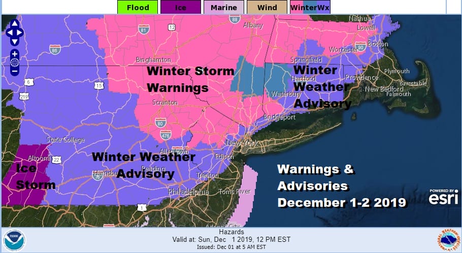
Winter Storm Warnings extend from Northeastern Pennsylvania & Northwest New Jersey to the Hudson Valley & Western Connecticut as well as much of upstate NY & Central New England. We have Winter Weather Advisories covering much of the rest of Pennsylvania, most of the northern half of New Jersey mainly north and west of the NJ Turnpike. Advisories cover Southern Westchester County in the Lower Hudson Valley and then east across Connecticut along and north of I-95.
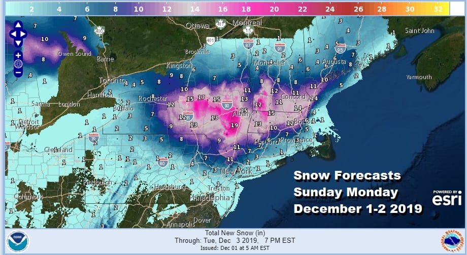
Here is the latest snow forecast map from the National Weather Service. Some numbers have been nudged a little bit with some of the highest amounts in the Hudson Valley and upstate NY coming down just a bit while other remain about the same or a touch lower. We remain unchanged on our snow forecast final call we put out yesterday.

Remember folks this is a two part storm and areas from NYC south and east will likely see their snow later Monday and Monday night on the backside of low pressure. That storm stalls out tomorrow east of New Jersey and south of Long Island.
SATELLITE

REGIONAL RADAR

This morning the first arm of precipitation is revving up with some scattered precipitation on the radar moving ahead of the main band that will overtake Pennsylvania this morning and head northeast. It reaches NYC around noon time and into the Connecticut, Hudson Valley and Long Island shortly afterward. Local radars will start to get busy this morning into this afternoon.
LOCAL RADAR NEW YORK CITY

LOCAL RADAR PHILADELPHIA


Warmer areas from NYC south and west will see a burst of snow and sleet that goes quickly to rain and doesn’t amount to much. Inland areas deal with a snow to sleet/freezing rain scenario this afternoon and evening.

The snow sleet line makes it rather far north into the Hudson Valley almost to I-90 before collapsing southward again. Areas to the south will see a lot of sleet and freezing rain into this evening down to near Route 287 in NY and into NW New Jersey. A brief break ensues tonight as the first round moves north. The we wait for the big pivot of the low off the New Jersey coast that will bring colder air back southward on Monday. Snow continues upstate and in New England overnight and Monday and then spreads southward through New Jersey to NYC as colder air returns.

How much occurs on the backside remains to be seen. We do have a vigorous upper air system that moves overhead Monday night into Tuesday morning and in the past, situations like this have produced surprises so we are on guard for one. This should all be done by Tuesday morning with weather conditions improving afterwards.
BE SURE TO DOWNLOAD THE FREE METEOROLOGIST JOE CIOFFI WEATHER APP &
ANGRY BEN’S FREE WEATHER APP “THE ANGRY WEATHERMAN!
MANY THANKS TO TROPICAL TIDBITS FOR THE USE OF MAPS
Please note that with regards to any severe weather, tropical storms, or hurricanes, should a storm be threatening, please consult your local National Weather Service office or your local government officials about what action you should be taking to protect life and property.


