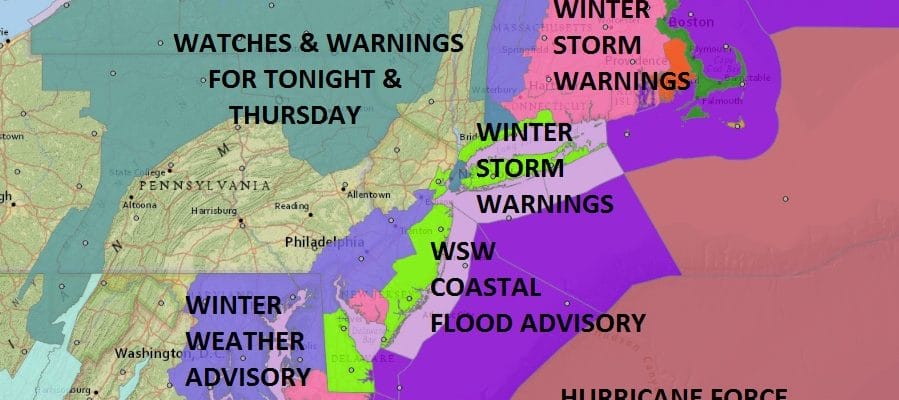
Winter Storm Warnings Weather Models Remain On Course
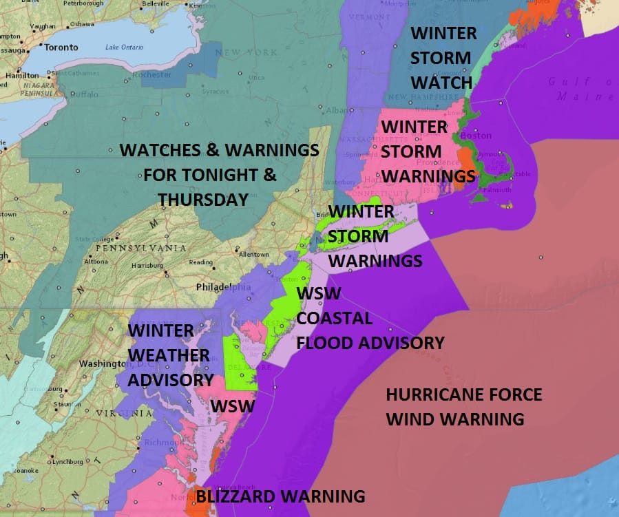
Winter Storm Warnings Weather Models Remain On Course
Everything we have looked at with weather models remains on course as this major Atlantic Ocean storm begins revving up off the Southeast US Coast. A NOAA plane is scheduled to arrive this evening which will give weather models extra data when we see them tonight. As far as what we have seen this afternoon there has been very little change in the overall picture. The European model which was the one model that was still not in line with the others has now joined the party by doubling its precipitation amounts to come in line with the others. At this stage we are now just waiting for all this to get underway tonight. Whiteout conditions have been occurring in parts of the Southeast US Coast. Take a look at these observations with all of Southeast South Carolina reporting moderate to heavy snow!
CITY           SKY/WX    TMP DP  RH WIND       PRES   REMARKS
N Charleston   HVY SNOW  29  23  78 N14       30.04F VSB 1/4 WCI  18
Waterfront Prk   N/A     27  26  96 N7        29.88F WCI  19
Mount Pleasant SNOW      28  27  93 CALM      30.05S VSB 1/2
Johns Island   SNOW      27  25  93 CALM      30.03S VSB 1/4
Pinopolis        N/A     27  25  93 N15       30.01F WCI  15
Moncks Corner  SNOW      25  23  93 N9        30.06F VSB 1/2 WCI  15
Summerville    LGT SNOW  27  23  86 N7        30.08F VSB 1   WCI  19
Beaufort MCAS  SNOW      26  25  96 N13       30.04F VSB 1/2 WCI  15
Beaufort Arpt  SNOW      27  25  93 N7        30.03F VSB 1/2 WCI  19
Hilton Head Is SNOW      28  27  93 N7        30.05F VSB 1/2 WCI  21
Walterboro     SNOW      27  23  86 N6        30.07F VSB 1/4 WCI  20
Allendale      LGT SNOW  25  23  93 N7        30.06F WCI  17
On the satellite loop this afternoon you can see the cloud signature of a very intense storm that is developing with the comma shape look. The northern energy continues to swing around across the Great Lakes and the north northeast motion is underway. High clouds from the the system are already overhead and they will thicken up this evening. Radars will begin to load up shortly to the southeast.
SATELLITE LOOP

REGIONAL RADAR

Snow will overspread the area from the south and southeast overnight and it will only get so far west into Eastern Pennsylvania. The western edge of the snow should make to west of Scranton & Harrisburg in Pennsylvania. The heavy snow will being to arc westward into the coastal areas of Virginia to Southern New England during the early morning hours.
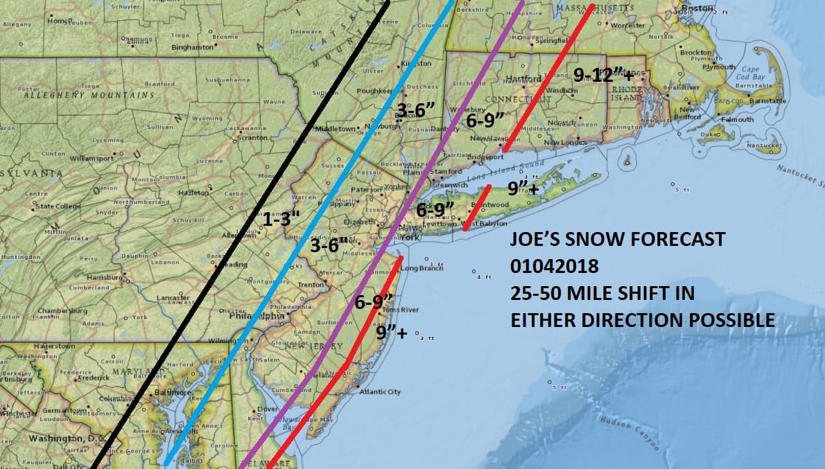
NATIONAL WEATHER SERVICE SNOW FORECAST

The map above shows the National Weather Service digital snow forecast amounts from this storm. Below is my forecast map from earlier today which remains unchanged. Bear in mind that the tight nature of the gradient between 1 inch and 6 inches. The convective nature of the snow plus banding that will develop will create wide variations in snow amounts. Thundersnow is possible over Long Island and Southeast New England.
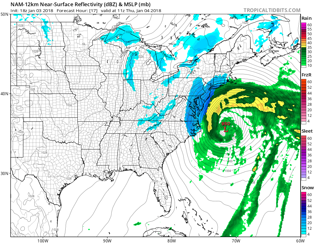
The very latest NAM model is out and it shows the intense extratropical cyclone off the coast of the Carolinas and the track that it is forecast will bring near blizzard conditions with heavy snow and near zero visibility over coastal areas from New Jersey to Long Island & Southeast New England as winds will gust to 50-60 mph at times.
NAM MODEL 6AM THURSDAY
Fortunately the fast movement will probably prevent snow amounts from getting out of hand. The snow will end from southwest to northeast during the afternoon and evening on Thursday. The coldest of the Arctic air masses we have seen will be in for Friday into Sunday and below zero readings are likely Saturday and Sunday morning. Many areas on Friday will see highs only in the single digits and low teens.
 GET JOE A CIGAR IF YOU LIKE

FiOS1 News Weather Forecast For Long Island
FiOS1 News Weather Forecast For New Jersey
FiOS1 News Weather Forecast For Hudson Valley


