
Winter Storm Threat Increases For Late Week
One of the things I leaned a long time ago was when all three models show the same thing, its a pretty good bet that it is likely going to happen. This is one of those rare times when all three models picked up on the idea of a major winter storm and as each model run has gone by, they have not waivered at all. The European, GFS, and Canadian all have remarkable consistency from tun to run. All pretty much have the same idea of snow on the order of a foot or more from Washington to Boston. What could possibly go wrong with the forecast? Well actually quite a bit could go wrong. I don’t think the issue is a storm track to the west or inland at this point. I think if there is any risk it would be a track a little further south and east. But I have to say the last 3 or 4 runs have seen the track clustered around a very close area without much variation.
WINTER STORM THREAT EUROPEAN MODEL


The key to all of this will be the delicate balance between the northern jet stream which holds in the cold air and the strong southern stream. Too strong in the south and it lifts up west..too weak and it doesn’t left up at all. This is that combination right now that yields a big Mid Atlantic/Northeast US snowstorm. Cold air holds..southern system strengthens as it moves underneath and offshore the coast. Models favor rapid deepening. This would be a powerful noreaster with gales, coastal flooding, and beach erosion among other things.
Winter Storm Threat GFS
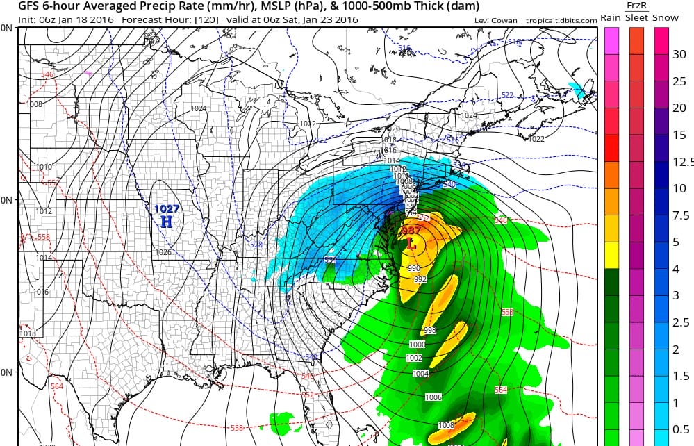
So where do we go from here? Well first things first is the local forecast for the first part of the work week for New York City/Long Island which is very cold and dry. Snow squalls have already passed through this morning and now its very cold with temperatures in the 20s. Meteorologist Geoff Bansen has more with the FiOS1 News weather broadcast for Long Island.
Now with regards to the longer term here is the latest GFS weather video analysis from the overnight model run.
NATIONAL WEATHER SERVICE SNOW FORECASTS
LATEST JOESTRADAMUS ON THE LONG RANGE
Weather App

Winter is here! Don’t be without Meteorologist Joe Cioffi’s weather app. It is a complete weather app to suit your forecast needs. All the weather information you need is right on your phone. Android or I-phone, use it to keep track of all the latest weather information and forecasts. This weather app is also free of advertising so you don’t have to worry about security issues with your device. An accurate forecast and no worries that your device is being compromised.
Use it in conjunction with my website and my facebook and twitterand you have complete weather coverage of all the latest weather and the long range outlook. The website has been redone and upgraded. Its easy to use and everything is archived so you can see how well Joe does or doesn’t do when it comes to forecasts and outlooks.
Just click on the google play button or the apple store button on the sidebar for my app which is onMy Weather Concierge. Download the app for free. Subscribe to my forecasts on an ad free environment for just 99 cents a month.
Get my forecasts in the palm of your hand for less than the cost of a cup of Joe!
![]()
![]()