Winter Storm Exits, Major Storm Heads to Great Lakes Tuesday into Wednesday
Heavy Rains, Strong Winds, Coastal Flooding

Winter Storm Exits, Major Storm Heads to Great Lakes Tuesday into Wednesday
Heavy Rains, Strong Winds, Coastal Flooding
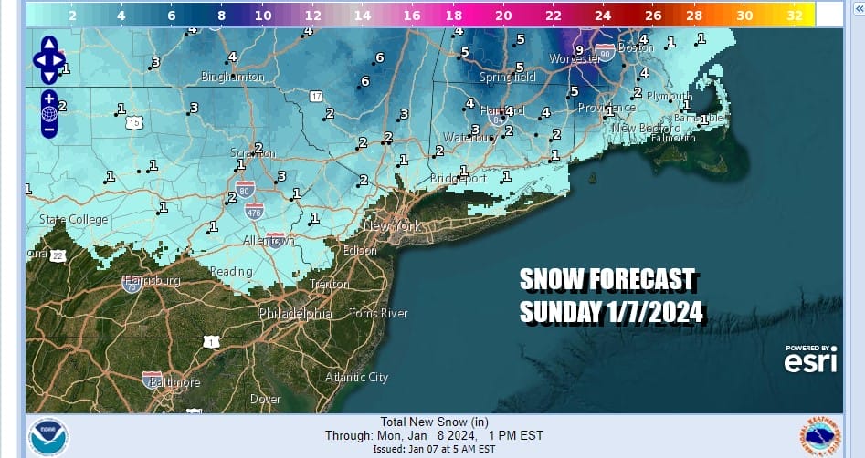
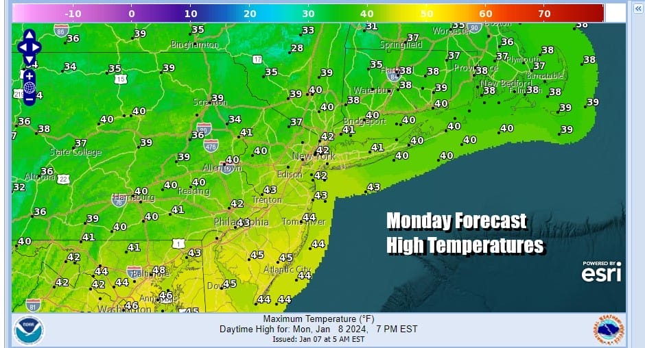
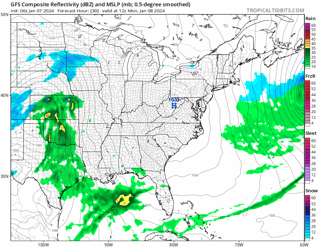
Yesterday’s and last night’s winter storm with snow inland and rain along coastal areas is going to be winding down today. Low pressure is moving along the south shore of Long Island. We will see intermittent snow away from the coast today and there could be another coating to an inch or two possible, though inland temperatures are mostly at or slightly above the freezing mark. I think any additional snow will be limited today and probably confined to colder surfaces. Along the coast we will see some patchy rain perhaps mixed with some snow that doesn’t amount to anything at all. Most temperatures today will be in the 30s except for areas in Southern New Jersey and Southern Pennsylvania which likely see highs in the lower 40s.
SATELLITE WITH LIGHTNING STRIKES

WEATHER RADAR

Southeastern New England is likely to see an additional few inches as that area deals with a strengtheing low pressure system that passes to the southeast of Cape Cod. Snow will end here late in the afternoon. Then area wide tonight skies should start to clear as the storm moves away. Most lows will be in the 20s to around 30 degrees so some refreeze will occur especially inland. Monday will be anice day of sunshine and highs in the low to mid 40s with upper 30s in snow covered areas.
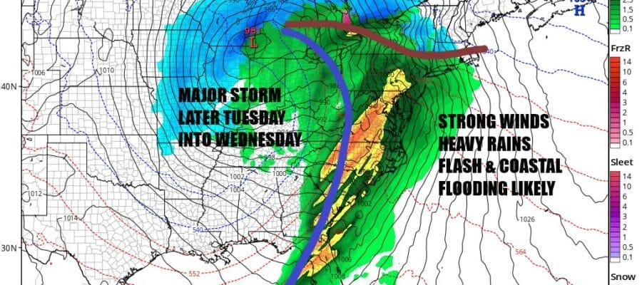
This is going to be a very busy stretch of weather. One storm winds down and now we have a major storm that will be developing in the Southern Plains and heading northeastward to the Great Lakes by early Wednesday. We already have Winter Storm and Blizzard Warnings posted for areas from Southeast Colorado and New Mexico northeast to Kansas and Nebraska with more watches and warnings to come. Across the South and Southeast heavy rain and severe weather will start later Monday and continue into Tuesday.
In the Northeast and Mid Atlantic we will see increasing clouds Monday night into Tuesday with deteriorating weather conditions during the day. Rain will develop from south to north in the morning to early afternoon. As the storm center heads to the Great Lakes, the pressure gradient gets exceptionally tight espcially along the coast. Winds will gust to 50 to 60 mph or more Tuesday night into Wednesday. Strongest winds will be along the coast but even inland areas will see gusts between 40 and 50 mph.
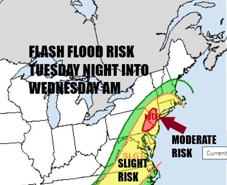
This storm is going to be coming right after a rather sizeable snowfall in areas inland so we have the combination of melting snow and the potential for two to 3 inches of rain. This is going to create flash flooding risks Tuesday night into Wednesday morning. It isn;t going to take much with a mostly saturated ground. There will also be thunderstorms possible Tuesday night into Wednesday morning.
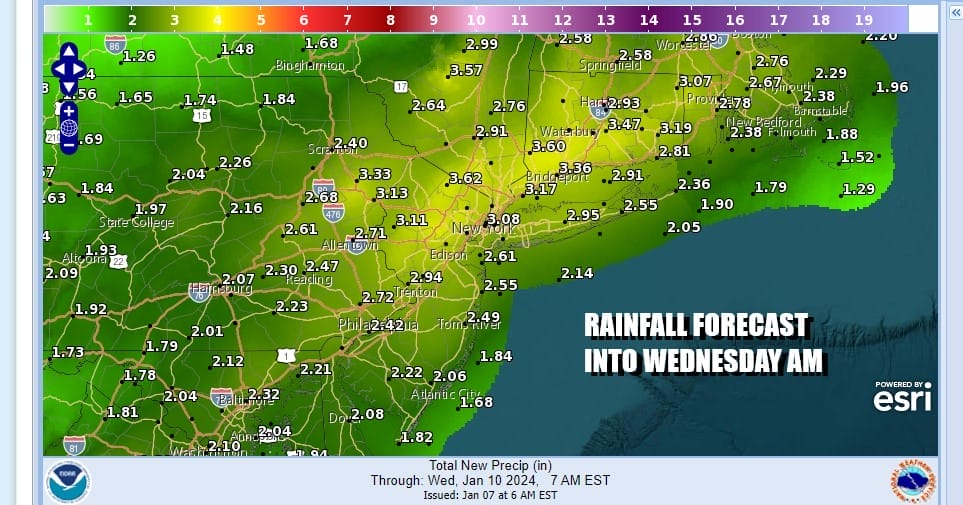
There is alos the issue of coastal flooding at high tide and we are approaching a new moon Thursday. Tides will be rising as we move through the week. Add to that a screaming south southeast wind and you have the potential for some areas of moderate coastal flooding, depending on the timing of the front and high tide. We will look at this closer in the coming days. Once the front passes heavy rain and thunderstorms will end from west to east and weather conditions will improve Wednesday afternoon. Temperatures Tuesday will be in the 40s and then rising into the 50s Tuesday night into early Wednesday, and then falling back into the 40s and 30s later Wednesday into Wednesady. Long range will be calm Thursday and Friday but models suggest another major storm to the Great Lakes will develop for next weekend and that could mean another wind and and rain storm for the Eastern US.
BE SURE TO DOWNLOAD THE FREE METEOROLOGIST JOE CIOFFI WEATHER APP &
ANGRY BEN’S FREE WEATHER APP “THE ANGRY WEATHERMAN!
MANY THANKS TO TROPICAL TIDBITS FOR THE USE OF MAPS
Please note that with regards to any severe weather, tropical storms, or hurricanes, should a storm be threatening, please consult your local National Weather Service office or your local government officials about what action you should be taking to protect life and property.
(Amazon is an affilate of Meteorologist Joe Cioffi & earns commissions on sales.)


