
Winter Predictions: Siberia Snow Cover Final Index Finishes 3rd Highest In 15 Years
We have the final index reading from the Siberian Snow Cover indicator which measures the rate of growth of snow cover in Siberia south of 60 degrees north. The theory is that the faster the rate of growth the greater the probability of a colder snowier winter than normal in the Eastern United States.
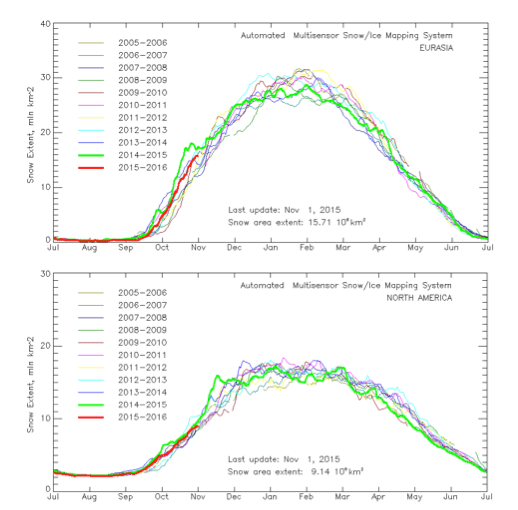
The charts above show the snow cover growth across Siberia south of 60 degrees north while the second chart shows the rate of snow cover growth across North America. With regards to the Siberian growth rate the index has finshed tied for number 3. It finishes behind the last 2 winters 2013-2014 and 2014-2015. It finished tied with 2009-2010. With regards to the North America snow cover growth for which we do not seem to have a strong correlation with snowy cold winters in the east, the snow cover looks to be running at number 2 right behind last winter.
One of the issues is the desired atmospheric response from all this. The theorists hold that this should create conditions that would favor the development of blocking in the atmosphere which did not occur in the last 2 winters so again this goes back to the idea that there are other factors at work when it comes to creating cold and snowy conditions that do not require blocking. We saw that the last 2 winters in the east. The question over the long term is whether there will be an atmospheric response that favors blocking. If there is not that particular response, then will the other factors take hold again. Or is the El Nino going to be the driver overall and overcome those other factors. That is the main difference this time around in that there was no El Nino present in the last 3 winters.

The map above is the sea surface temperature anomalies for the Pacific Ocean and you can see the El Nino extending into the Central Pacific. As we pointed out in earlier posts on this the eastern most part of this El Nino needs to continue to weaken and the El Nino needs to shift to the Central Pacific which would favor colder conditions in the east. As this stands now the El Nino continues to dominate the weather pattern so we will continue to watch the short term changes there as they develop through the month of November.
If you missed it here are my winter predictions for 2015-2016.