
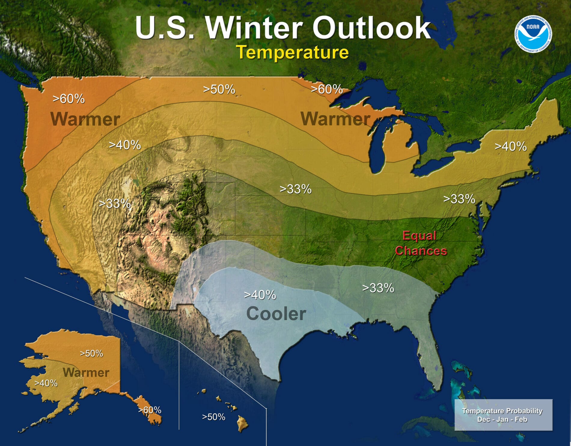
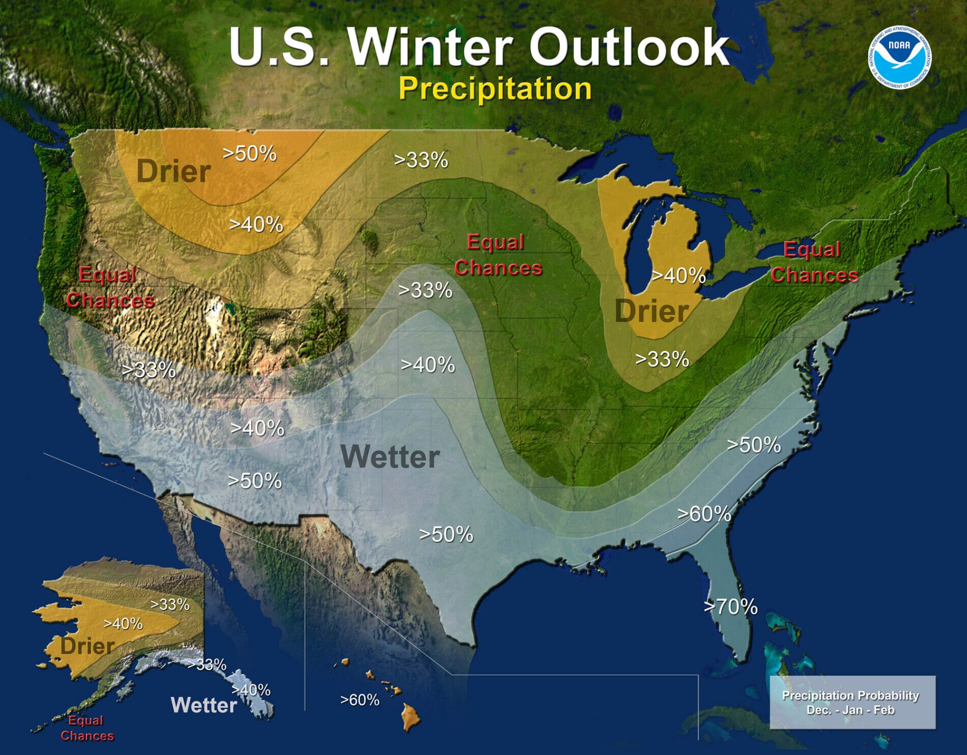
The Winter Outlook from the climate folks is out and it is heavily el nino based. JOESTRADAMUS however points out they did acknowledge that there are other factors at play
“A strong El Niño is in place and should exert a strong influence over our weather this winter,” said Mike Halpert, deputy director, NOAA’s Climate Prediction Center. “While temperature and precipitation impacts associated with El Niño are favored, El Niño is not the only player. Cold-air outbreaks and snow storms will likely occur at times this winter. However, the frequency, number and intensity of these events cannot be predicted on a seasonal timescale”
One of the things that struck me yesterday was this tweet from Ryan Maue who posted this graphic of the current El Nino and then the 1997 El Nino subtracted out so that we see the differences and the differences are substantial! This is what I think is being missed by those who are reflexively going for the 97-98 comparison.
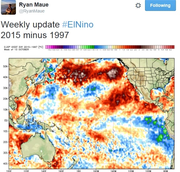
What the graphic shows is that the water temperatures all across the northern Pacific are completely different from 1997-98 and the same holds true from what we can see in the Atlantic! This really strengthens the argument against picking one particular comparison against 1997-98 or 1982-83 or 1957-58 or any others you can come up with. The warm water in the Northeast Pacific would argue for a colder than normal flow of air into the northeast while the el nino would be the reverse. What we might wind up seeing (just thinking out loud here) is perhaps a wider than normal battle ground zone where ice becomes an issue though it would play out further south than it did in 1997-1998. Thank you Ryan for this. Now could you do one for 1982-1983?
Back to the National Climactic Center forecast, they acknowledge that there are many other factors at play that need to be considered and I have been arguing the Atlantic will be playing a bigger role at the end of the day than in past winters. Siberian snow growth is on pace but slightly behind the last two winters which is sort of no brainer that it would be. Pattern signals continue to call for blocking to develop in the Atlantic over the next few weeks. In the end with all this battling over data, the irony might be the winter doing something that it hardly ever does and that is finish exactly normal on all counts!
Be sure to download my app and subscribe to my weather forecasts for New York New Jersey Eastern Pennsylvania and Southern New England. The app is free and a subscription is just 99 cents a month.