Wind Advisories Severe Weather Risks Weekend Outlook Dry Colder
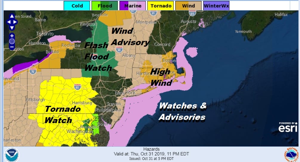
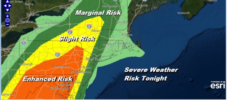
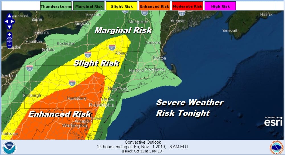
Wind advisories will go into effect tonight for upstate NY,all of Southern New England and Long Island which includes Brooklyn and Queens. Wind Advisories have now been issued for the New Jersey coastal counties. These advisories are what has been up as of 3pm Eastern time and we could see some additions this evening by local weather service offices. We have also seen the Storm Prediction Center Expand the risk area for severe weather tonight pushing all the risk areas further north and east.
Since we are in the warm sector here other than patches of showers or some light rain or drizzle not much really happens until long after the evening commute is done. We have lots of clouds but there are actually some breaks that have shown up well south into New Jersey and down into Virginia and North Carolina where the day time heating is getting maximized. Despite the clouds here we managed to reach the upper 60s and low 70s here today and we will likely hold near those levels until the cold front comes through.
SATELLITE

REGIONAL RADAR

Regional radar is busy across Pennsylvania with downpours moving northeast and most of those pass north and west of Philadelphia and NYC though the eastern flank could catch a few spots this evening. Local radars are also picking up on some clusters of showers. We will watch the regional radar load up this evening as thunderstorms move into Pennsylvania and strengthen.
LOCAL RADAR NEW YORK CITY

LOCAL RADAR PHILADELPHIA


The main frontal action with thunderstorms will be from 10-11pm in Eastern Pennsylvania and Western NJ. Those showers and thunderstorms should reach the Hudson Valley east of the Hudson River, NYC and the Jersey shore around midnight and over Long Island and Connecticut shortly afterward. As the front passes given the sharp nature of it, winds will pick up considerably this evening and become strong and gusty. Some gusts to 50 mph are possible especially along the coast as the front passes.
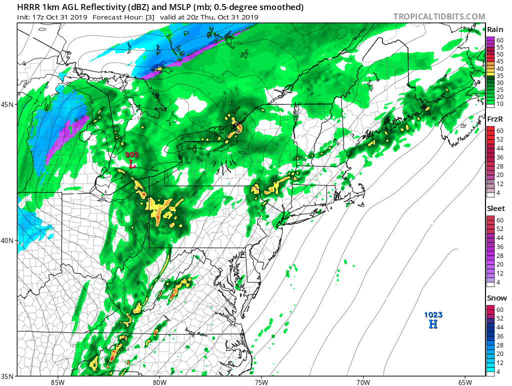
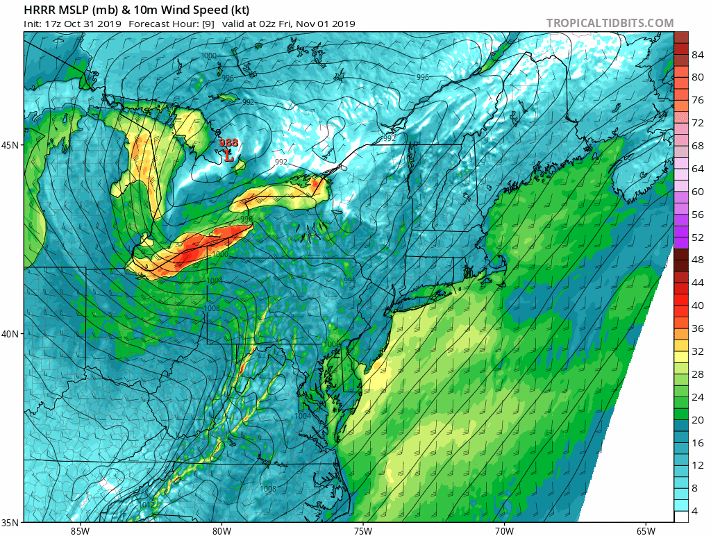
We have the HRRR model above which starts at 5pm and ends at 6am Friday. We have problems with all the models in terms of how they represent the front and the radar presentation. They seem underdone compared to what we are actually seeing on the radars at the moment. I don’t have problem with the timing issue. The front moves through fast and note the sharp V shaped front that move though indicating a rather turbulent atmosphere with a sharp windshift from southwest to northwest as the front goes by. Bursts of wind are likely here when the front passes regardless of whether the storms hold together or not.
We also have the HRRR wind forecast. These show sustained winds and we can see the fast development of gales this evening. The first frame is at 10pm Thursday and the last is 4am Friday. This would certainly support gusts of 40 to 50 mph with that sharp V structured front moves on through. Weather conditions improve on Friday with sunshine returning with a gusty wind and temperatures in the 50s. The weekend looks dry and chilly with some sun and clouds both Saturday and Sunday with daytime highs in the low to mid 50s. Nighttime lows will be in the 30s with 20s in cold spots and near 40 in some warmer urban areas.
WEATHER IN 5 VIDEO 2PM THURSDAY
BE SURE TO DOWNLOAD THE FREE METEOROLOGIST JOE CIOFFI WEATHER APP &
ANGRY BEN’S FREE WEATHER APP “THE ANGRY WEATHERMAN!
MANY THANKS TO TROPICAL TIDBITS FOR THE USE OF MAPS
Please note that with regards to any severe weather, tropical storms, or hurricanes, should a storm be threatening, please consult your local National Weather Service office or your local government officials about what action you should be taking to protect life and property.


