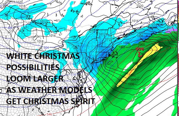
White Christmas Odds Increasing Christmas Eve Night Into Christmas Day
White Christmas Odds Increasing Christmas Eve Night Into Christmas Day
Judging by the latest model runs it appears that the odds of a White Christmas for our area are increasing and there is still time for models to maneuver westward a bit since that has been the trend for the last 6 to 8 weeks and was the trend with the three systems last week. This in a way is like the system from last Friday which developed basically in our back yard. The difference here is that there is a bit more energy to play with as the upper trough swings around and the developing is starting out a bit further to west as the trough swings and lifts northeastward.
GFS FORECAST SUNDAY CHRISTMAS EVE INTO CHRISTMAS DAY CLICK TO ANIMATE
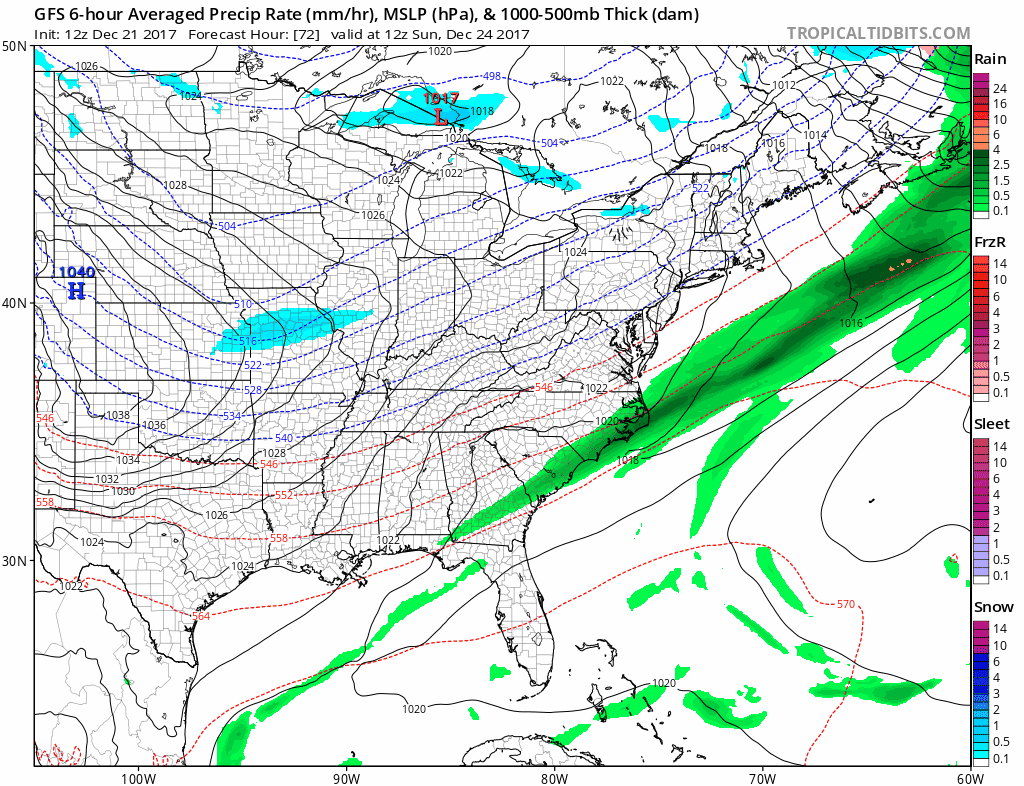
The GFS model is coming into line with the other models from overnight and yesterday with this idea and that is no surprise since it loves to flatten things out to the east and overwhelm cold air. The Canadian has a similar idea today as well. I think based on what I am seeing at the moment areas from Route 78 in New Jersey to NYC & Long Island have a shot at seeing a coating to a couple of inches from this while areas along and north of Route 80 to along and north of 287 in Westchester County and in Connecticut north of Route 15 stand a good chance of seeing perhaps several inches of snow or even a bit more depending on development. We will wait for the European and a few other models to verify this. Last night’s European model produce 1 to 3 inches of snow for areas just inland of the coast in the Hudson Valley, NW New Jersey and much of Connecticut. Along and north of Route 84 it showed 3 to 6 inches from New Jersey to Southeast NY to Connecticut. We will also put out a first call snow map later today.
MANY THANKS TO TROPICAL TIDBITS FOR THE WONDERFUL USE OF THE MAPS

GET JOE A CIGAR IF YOU LIKE!
FiOS1 News Weather Forecast For Long Island
FiOS1 News Weather Forecast For New Jersey
FiOS1 News Weather Forecast For Hudson Valley
NATIONAL WEATHER SERVICE SNOW FORECASTS
LATEST JOESTRADAMUS ON THE LONG RANGE
Weather App

Don’t be without Meteorologist Joe Cioffi’s weather app. It is really a meteorologist app because you get my forecasts and my analysis and not some automated computer generated forecast based on the GFS model. This is why your app forecast changes every 6 hours. It is model driven with no human input at all. It gives you an icon, a temperature and no insight whatsoever.
It is a complete weather app to suit your forecast needs. All the weather information you need is right on your phone. Android or I-phone, use it to keep track of all the latest weather information and forecasts. This weather app is also free of advertising so you don’t have to worry about security issues with your device. An accurate forecast and no worries that your device is being compromised.
Use it in conjunction with my website and my facebook and twitter and you have complete weather coverage of all the latest weather and the long range outlook. The website has been redone and upgraded. Its easy to use and everything is archived so you can see how well Joe does or doesn’t do when it comes to forecasts and outlooks.
Just click on the google play button or the apple store button on the sidebar for my app which is on My Weather Concierge. Download the app for free. Subscribe to my forecasts on an ad free environment for just 99 cents a month.
Get my forecasts in the palm of your hand for less than the cost of a cup of Joe!