What A Difference From Yesterday’s 90s Today 50s Big Chill Coming Friday Night
At this time yesterday we were in the low to mid 90s and setting either new or all time record highs. 24 hours later and we are 35 to 40 degrees colder in what is a cloudy raw and in some cases a rainy day. Temperatures are in the 50s in most places and some areas from Northeast Pennsylvania to Southern New England are in the 40s. If you average the two days together you have something that looks like normal for this time of year. The frontal boundary to the south is sharp with a solid overcast down into Virginia. Low pressure and a cold front will be pushing east as the frontal boundary from the south pushes north tonight. Some more rain or showers are possible through tonight.
SATELLITE

REGIONAL RADAR

Regional radar for now shows most of the rain north and northeast of New York City. There are some showers developing to the west in Pennsylvania and we will probably see more of them tonight as the cold front moves through. Temperatures could start to push higher tonight as the warm front to the south gets close and the cold front moves east and passes offshore early Friday morning. Showers then will move out to the east.
LOCAL RADAR NEW YORK CITY

LOCAL RADAR PHILADELPHIA


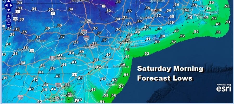
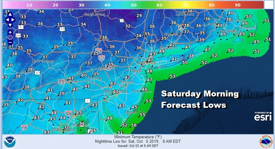
Friday clouds will give way to sunshine and a gusty wind as colder air drains southward from high pressure over the Great Lakes and Eastern Canada. Temperatures will be in the 60s. Friday night into Saturday morning will be quite chilly with most lows away from warmer urban centers in the 30s. Warmest spots will be in the low to mid 40s. There is the chance for some frost in areas north of the coast if winds drop off to calm overnight.
Saturday will be the better of the 2 weekend days with lots of sunshine but it will be a rather cool apple/pumpkin picking type of day with highs just in the upper 50s and lower 60s. Clouds will return Saturday night as winds go around to the south on Sunday. Sunday we will see early sun giving way to arriving clouds. The next cold front will be approaching. Temperatures will be in the 60s to near 70. Showers should hold off until Monday.

Once this front moves offshore, weather conditions improve on Tuesday with some sunshine and seasonal temperatures returning. Much of next week looks dry with the next cold front approaching late Friday or Saturday. No major storms are on the horizon.
MANY THANKS TO TROPICAL TIDBITS FOR THE USE OF MAPS
Please note that with regards to any tropical storms or hurricanes, should a storm be threatening, please consult your local National Weather Service office or your local government officials about what action you should be taking to protect life and property.


