Wet Tuesday Morning Commute

Wet Tuesday Morning Commute
Rain 1/2 Inch
Weather Improves PM
Dry & Cool Wednesday Through Friday

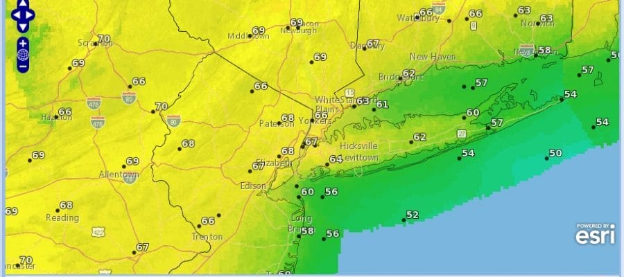
Rain is coming in for the morning commute across the area from New York City Connecticut Long Island and the Hudson Valley, southwestward toward Philadelphia, Southern New Jersey & Southeastern Pennsylvania. The weather front moving through shows no signs of buckling so it will be a fairly ordinary area of rain that moves through and then gradually ends through the morning to early afternoon from west to east. Amounts could total about a 1/2 inch across the entire area as rainfall amounts look pretty uniform throughout. Radar shows a sharp cut off on the back edge and clouds thin out quickly. We should see some sunshine develop during the afternoon. Temperatures will be in the mid to upper 50s ahead of the front, and then gradually settle into the upper 40s and lower 50s late in the afternoon.
Wet Tuesday Morning Commute Radar Loop

Wet Tuesday Morning Commute Local Radar Loops


Skies will clear out Tuesday night with lows in the 30s to around 40. Wednesday looks nice with sunshine but we will have a northeast wind. In fact that wind will be dominating right through Friday. This brings down cool but dry air from New England. Other than occasional patchy clouds from time to time, most of the days will feature sunshine and highs each day will be mostly in the 50s. It might be a little cooler along the coast with this onshore flow.
Saturday & Sunday High Temperatures
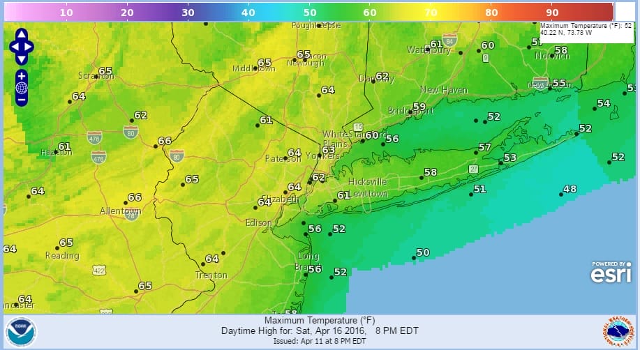
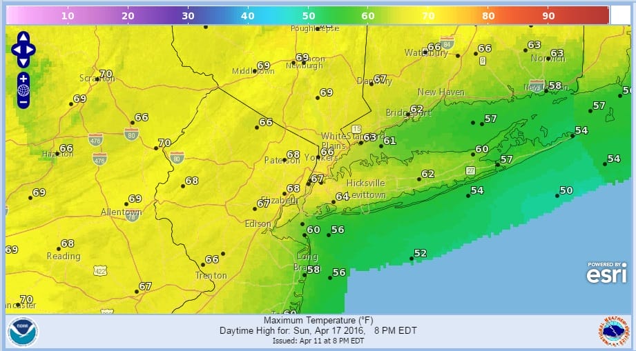
An early look at the weekend shows the onshore flow disappearing and a more westerly flow takes over. It looks dry with some sunshine for both Saturday and Sunday with highs into the 60s on Saturday and into the 70s on Sunday. I think the Sunday temperature map is underdone by about 5 degrees.
FiOS1 News Weather Forecast For Long Island
FiOS1 News Weather Forecast For New Jersey
FiOS1 News Weather Forecast For Hudson Valley
NATIONAL WEATHER SERVICE SNOW FORECASTS
LATEST JOESTRADAMUS ON THE LONG RANGE
Weather App

Don’t be without Meteorologist Joe Cioffi’s weather app. It is really a meteorologist app because you get my forecasts and my analysis and not some automated computer generated forecast based on the GFS model. This is why your app forecast changes every 6 hours. It is model driven with no human input at all. It gives you an icon, a temperature and no insight whatsoever.
It is a complete weather app to suit your forecast needs. All the weather information you need is right on your phone. Android or I-phone, use it to keep track of all the latest weather information and forecasts. This weather app is also free of advertising so you don’t have to worry about security issues with your device. An accurate forecast and no worries that your device is being compromised.
Use it in conjunction with my website and my facebook and twitter and you have complete weather coverage of all the latest weather and the long range outlook. The website has been redone and upgraded. Its easy to use and everything is archived so you can see how well Joe does or doesn’t do when it comes to forecasts and outlooks.
Just click on the google play button or the apple store button on the sidebar for my app which is on My Weather Concierge. Download the app for free. Subscribe to my forecasts on an ad free environment for just 99 cents a month.
Get my forecasts in the palm of your hand for less than the cost of a cup of Joe!
![]()
![]()

MENTION JOE CIOFFI AND GET A 5% DISCOUNT


