DOWNLOAD MY NEW FREE JOESTRADAMUS WEATHER APP FOR ALL DEVICES
THE APP IS ABSOLUTELY FREE TO ALL BUT CONSIDERING SUBSCRIBING TO PATREON FOR A WEATHER EXPERIENCE FREE OF ADS, EXCLUSIVE VIDEOS FOR MEMBERS ONLY AND MUCH MORE…STARTS AT $2 A MONTH..MESSAGE ME AT ANY TIME
Weekend Outlook Saturday Better Day 70s Showers Sunday Night
The Plains snow storm continues to rage across South Dakota and Central Minnesota with 1 foot plus amounts in many areas as of this morning. The large circulation of the storm sent blow off high clouds over us today and we continue to struggle with those clouds though based on latest satellite loops those clouds have tried to shift northward. Temperatures as a result were held down and stayed primarily in the 50s and some coastal areas and spots north of the coast didn’t even get out of the 40s today.
SATELLITE

Regional radar shows showers in Upstate NY moving southeast and weakening as they do so. Some sprinkles have occasionally showed up on the upton radar but they should gradually dry out later this evening and we expect no radar issues overnight and during the day on Friday.
REGIONAL RADAR

LOCAL RADAR NEW YORK CITY

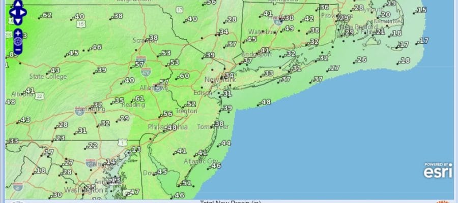
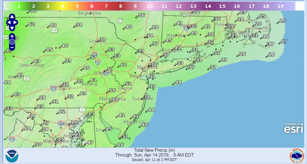
The outlook going forward remains unchanged. Expect clouds to move back in on Friday even if they get out for awhile overnight. Lows tonight will be mostly in the 40s with some 30s in colder spots. Temperatures on Friday should make it into the 60s away from the coast with a south southwest wind developing. Some breaks of sun are possible but not guaranteed. Showers should hold off until Friday night and most places won’t see any until after midnight. Rain will last into Saturday morning and end northwest to southeast after daybreak but some areas will take longer than others. Rainfall amounts should be on the order of a third to a half an inch in most places.
Saturday will be a day where clouds give way to sunshine. Temperatures will respond according to how much sun you get but 70s remain doable in many areas except perhaps right near the immediate coast where local sea breezes will occur. Then it is on to Sunday as a stronger cold front approaches and low pressure heads to our west. There is more moisture with this. Sunday itself will likely be cloudy with a south wind. I don’t expect much in the way of rain during the day on Sunday. Sundays highs will be in the 60s in most places. Sunday night and Monday will be a different story with rain developing and lasting into midday Monday. This could be a 1 to 2 inch rain producer for most of the area. Rain should be done by midday and weather conditions should start to improve Monday afternoon.
We have more on the very wet pattern that is developing in our JOESTRADAMUS long range post.
MANY THANKS TO TROPICAL TIDBITS FOR THE USE OF MAPS
Please note that with regards to any tropical storms or hurricanes, should a storm be threatening, please consult your local National Weather Service office or your local government officials about what action you should be taking to protect life and property.


