DOWNLOAD MY NEW FREE JOESTRADAMUS WEATHER APP FOR ALL DEVICES
THE APP IS ABSOLUTELY FREE TO ALL BUT CONSIDERING SUBSCRIBING TO PATREON FOR A WEATHER EXPERIENCE FREE OF ADS, EXCLUSIVE VIDEOS FOR MEMBERS ONLY AND MUCH MORE…STARTS AT $2 A MONTH..MESSAGE ME AT ANY TIME
Weekend Outlook Palm Sunday Outlook Wet Pattern Ahead
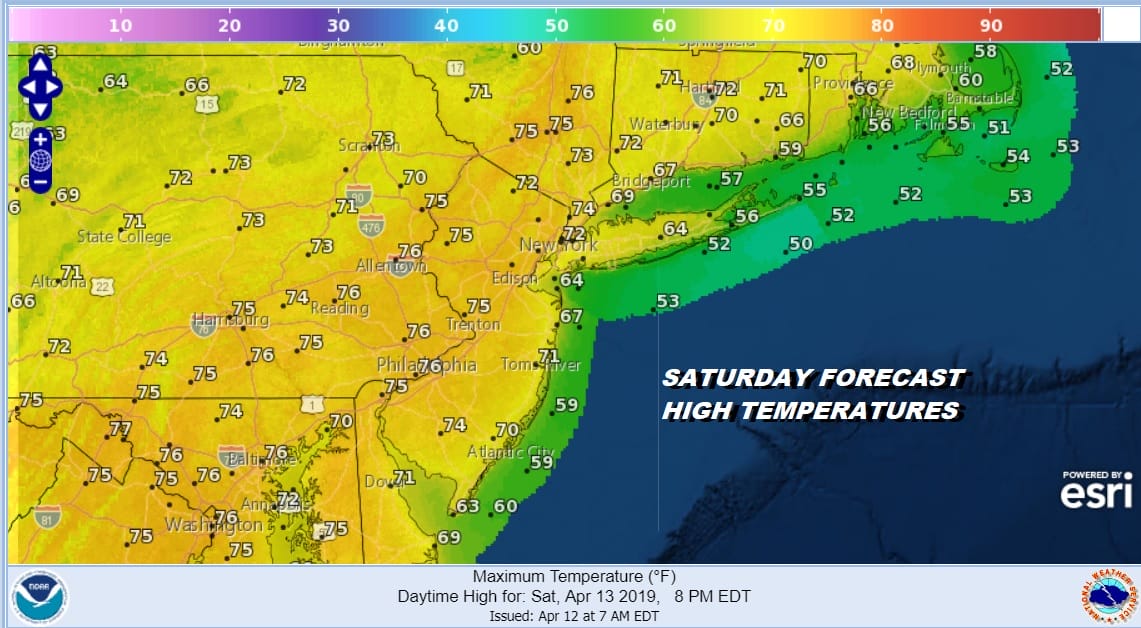
The week comes to a close and the Plains blizzard continues to churn northward to the Western Great Lakes. On the satellite loop this morning we see the trailing cold front that runs from the Central Great Lakes southward to the Gulf of Mexico. A southerly flow is opening up along the East Coast and that is going to keep us in clouds. The storm is weakening so this will be a round of showers overnight into early Saturday morning and that is it. We also could see a few breaks of sun developing in the clouds later today in some areas inland and south of NYC. That could impact high temperatures today which will be in the upper 50s and lower 60s except where the sun magically appears and those areas could see 70 or better. The best chance for this is Central & South Jersey and Southeast Pennsylvania.
SATELLITE

REGIONAL RADAR

There isn’t too much going on at the moment on the radar with some patchy drizzle showing up in the local radars. Showers and thunderstorms from the cold front to the west aren’t in range of the regional radar at the moment but that will change as the day wears on. None of those showers will reach us until later this evening or more than likely overnight.
LOCAL RADAR NEW YORK CITY

LOCAL RADAR PHILADELPHIA


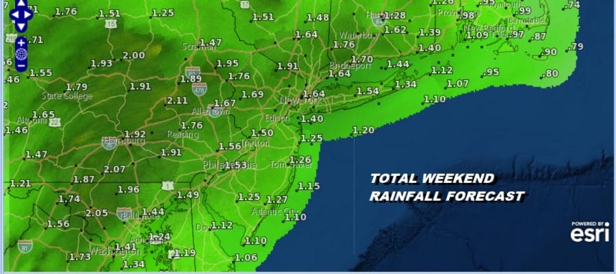
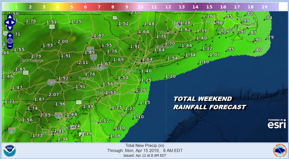
Showers overnight into early Saturday morning will likely produce a third to two thirds of an inch of rain. Then it becomes a question of whether the sun can successfully break through the clouds on Saturday. Areas that do this quickly will see high reach the 70s and even 80 degrees is not out of the question. The coast might stay in the 60s to near 70 as clouds here could take longer to get out of the way.
Palm Sunday brings clouds again as the next storm moves out of Texas and heads to the Ohio Valley and then into Upstate NY Sunday night into Monday. Another cold front and another round of showers and possibly a few scattered thunderstorms will come in. Sunday’s highs will be mostly in the 60s. Much of the activity will hold off until Sunday night into Monday morning. Rainfall from the Friday night system and the Sunday night system will produce 2 or more inches of rain in some areas.
Showers will move out Monday morning and weather conditions will improve later in the day with clouds and some breaks of sun possible Monday afternoon with highs in the 60s. Next week we will see the next system revving up with a strong cold front arriving late in the week. In between we will be dealing with the potential for onshore winds, clouds, and the chance for showers before another strong cold front arrives late Thursday and Friday. The pattern is busy and active thanks to an unrelenting Pacific jet sending weather systems across the US in rapid succession. The pattern may start to alter a bit in the long range as we head toward the end of the month.
MANY THANKS TO TROPICAL TIDBITS FOR THE USE OF MAPS
Please note that with regards to any tropical storms or hurricanes, should a storm be threatening, please consult your local National Weather Service office or your local government officials about what action you should be taking to protect life and property.


