Weather Models Remain Volatile Active Colder Long Range

Weather Models Remain Volatile Active Colder Long Range
Over the last week we have seen weather models all over the place in the long range. The important thing to focus on is that the atmosphere is stretched to extremes at the moment and this is going to mean more volatility in the day ahead. The best way to look at this is to view the upper air and the things that will be driving models to change further going forward. The way I see it is that the overall pattern will remain active. Even though we will moderate for a few days next week, Canadian cold air will be a player in some fashion. The questions are when where and how.
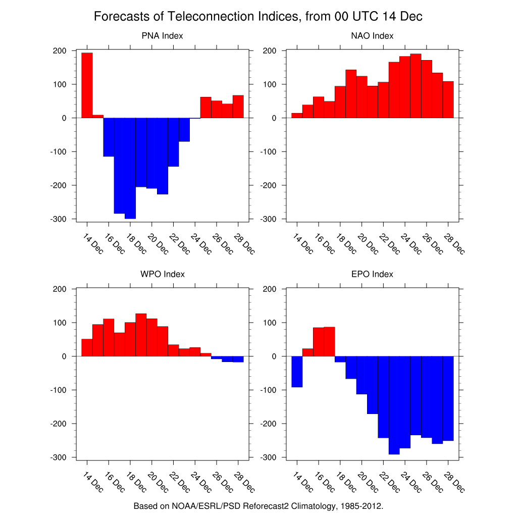
Looking at the teleconnection indices they are not only in extreme positions over the next week but they are also changing rapidly. The least important right now is the NAO which is positive right through Christmas but we have stated many times that of the 3 we look at the most this is the least important at the moment.
The two important ones are the Pacific North America index and the Eastern Pacific Oscillation. These indices basically describe the changes in pressure across their areas. The PNA goes strongly negative next week for a few days and then rises rapidly to neutral and then goes positive around Christmas. The Eastern Pacific Oscillation goes strongly negative toward Christmas and beyond. A negative EPO usually means cold for the East. The PNA going positive is a strong storm indicator for the east because it means there is a ridge in the west. The period where it crosses the neutral zone could be a good place for some sort of storm signal which would mean sometime around December 24-26.
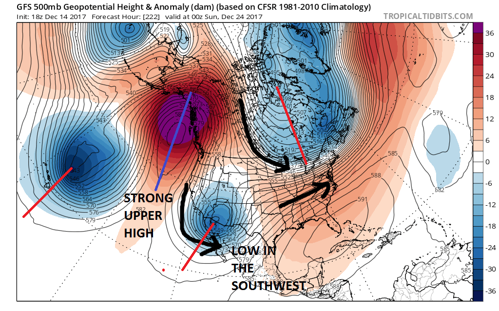
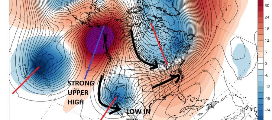
Here is what is important. Today’s model runs seem to want to drive a trough into the Southwest US but today’s runs separate this from the low in Canada which splits the jet in 2. The colder northern stream is present. The Southwest low will be ejecting energy eastward. The zone between warm and cold air will be close and where it lies will be basically the snow ice rain line. This to me suggests a couple of overrunning events in the longer term which would be a change from the clipper systems of late.
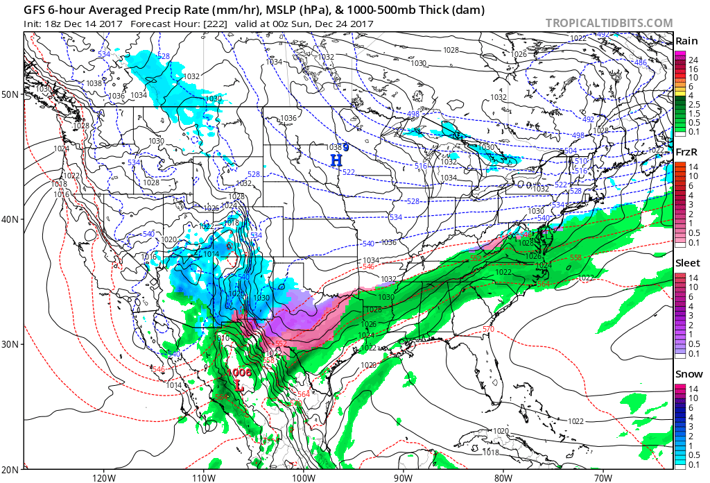
Here is the surface that matches up with the upper air. Cold air spreads out across the Plains to the northeast with a stalled out front to the south from Texas to the Southeast coast. Where this zone lies has been changing depending on the strength of the flow in Canada. If the Southwest system separates and if the Canada influence here is stronger it will create a colder environment here and actually the models do turn significantly colder from here. Watch for these trends in the models going forward as they will determine we go as Christmas and New Years approach.
In the meantime we will moderate for a couple of days next week and then turn colder midweek for a day or two. After that it will depend on how well models handle all these players. Exciting and difficult times lie ahead for forecasters. So far this month we have seen two snow events produce accumulating snows and in the short term we are watching this coastal system for Friday which is doing a last minute westward shift. Models have been handling this very poorly and again the extreme state of the atmosphere is likely to blame for this. Tonight’s models will be out shortly and if it shifts westward again, our area could see the third snow event in 6 days and this is just the first half of December! For more on the system for Friday read my earlier JOESTRADAMUS post.
MANY THANKS TO TROPICAL TIDBITS FOR THE WONDERFUL USE OF THE MAPS

GET JOE A CIGAR IF YOU LIKE!
FiOS1 News Weather Forecast For Long Island
FiOS1 News Weather Forecast For New Jersey
FiOS1 News Weather Forecast For Hudson Valley
NATIONAL WEATHER SERVICE SNOW FORECASTS
LATEST JOESTRADAMUS ON THE LONG RANGE
Weather App

Don’t be without Meteorologist Joe Cioffi’s weather app. It is really a meteorologist app because you get my forecasts and my analysis and not some automated computer generated forecast based on the GFS model. This is why your app forecast changes every 6 hours. It is model driven with no human input at all. It gives you an icon, a temperature and no insight whatsoever.
It is a complete weather app to suit your forecast needs. All the weather information you need is right on your phone. Android or I-phone, use it to keep track of all the latest weather information and forecasts. This weather app is also free of advertising so you don’t have to worry about security issues with your device. An accurate forecast and no worries that your device is being compromised.
Use it in conjunction with my website and my facebook and twitter and you have complete weather coverage of all the latest weather and the long range outlook. The website has been redone and upgraded. Its easy to use and everything is archived so you can see how well Joe does or doesn’t do when it comes to forecasts and outlooks.
Just click on the google play button or the apple store button on the sidebar for my app which is on My Weather Concierge. Download the app for free. Subscribe to my forecasts on an ad free environment for just 99 cents a month.
Get my forecasts in the palm of your hand for less than the cost of a cup of Joe!