DOWNLOAD MY NEW FREE JOESTRADAMUS WEATHER APP FOR ANDROID

THE APP IS ABSOLUTELY FREE TO ALL BUT CONSIDERING SUBSCRIBING TO PATREON FOR A WEATHER EXPERIENCE FREE OF ADS, EXCLUSIVE VIDEOS FOR MEMBERS ONLY AND MUCH MORE…STARTS AT $2 A MONTH..MESSAGE ME AT ANY TIME

Weather Models Pointing To Southern Snowstorm Early Next Week
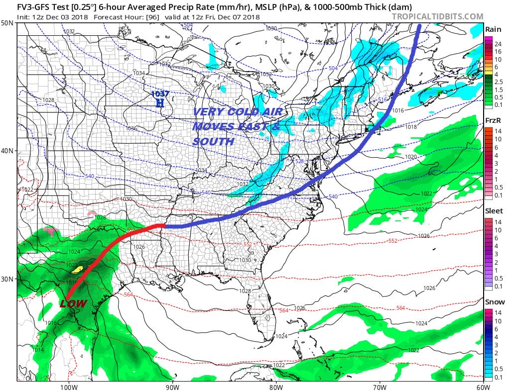
Colder air will be overwhelming the Eastern US for the next week as a colder pattern returns. It is a storm free pattern into the weekend with just cold fronts passing through. One is coming through today which will bring temperatures down to below average the next 3 days. The next front will arrive later Thursday night into Friday morning. This will take temperatures down a bit further Friday and over the weekend. This cold air mass will bleed into the Southeastern US and that sets the table for low pressure coming out of the Gulf States over the weekend.
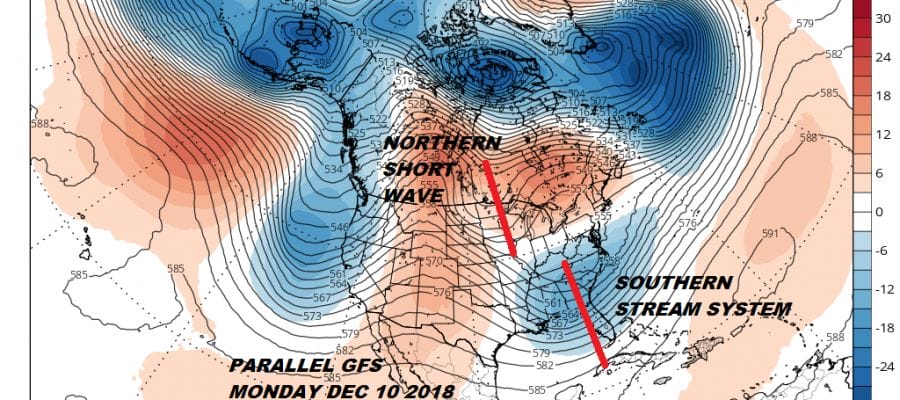
The issues with the upper air continue and whether this system becomes a problem further north than Virginia hinge on the behavior of the northern jet stream. There are many moving parts in this pattern and we have been discussing for days the issues with that northern jet.
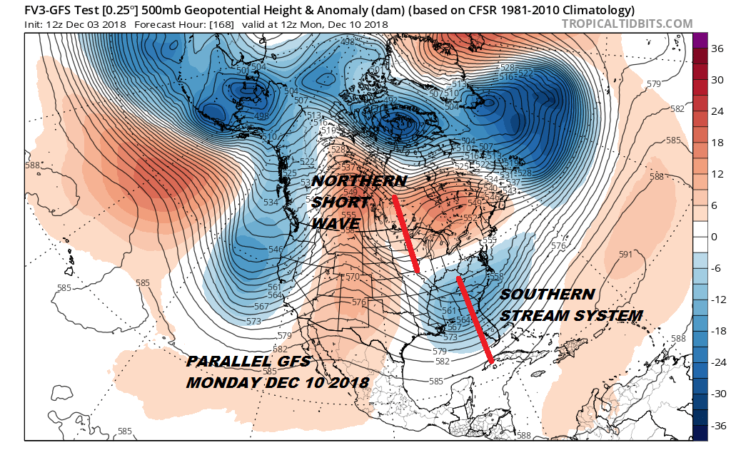
The parallel GFS which is the newly upgraded GFS (but not ready for prime time yet) shows the two separate streams in play here. The two streams remain separate as the model forecasts that northern shortwave trough not getting involved with the south. In other words they don’t phase together. A little phasing would take the surface low further north up the coast and open up a snow threat for the Northern Middle Atlantic states into Southern New England. The European has an even more squashed look to this.
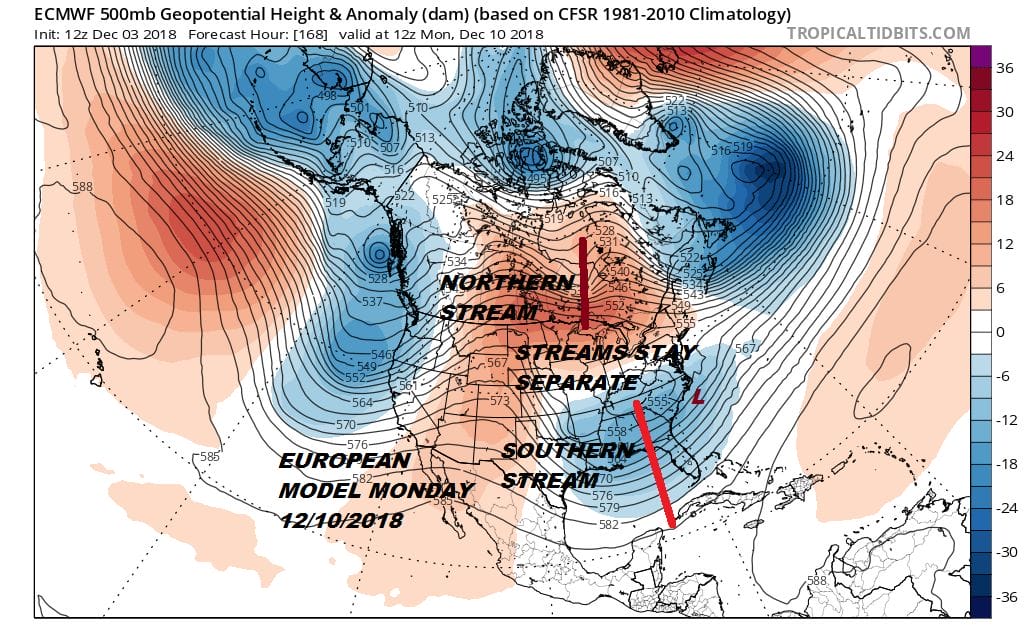
The streams stay so separate that the southern stream is actually forced southeastward once the coastal low is off the North Carolina coast. We have not seen any indication of any phasing on the GFS, the parallel GFS or the European. Only the Canadian makes the case for that northern jet stream to come down enough to bring the storm up the coast. The current view continues to support the idea that this could be a rather sizable snowfall for the southern states from Northern Arkansas to Tennessee and from Southern Virginia to North Georgia away from the coast. Obviously there is still time for models to maneuver a bit but for this storm to impact areas north of 35 degrees north (Southern Virginia) we are going to need to see major changes in the northern polar jet stream from where it stands at the moment.
MANY THANKS TO TROPICAL TIDBITS FOR THE USE OF MAPS
Please note that with regards to any tropical storms or hurricanes, should a storm be threatening, please consult your local National Weather Service office or your local government officials about what action you should be taking to protect life and property.