
Weather Models Key On Powerful East Coast Storm Sunday
Weather Models Key On Powerful East Coast Storm Sunday
Overnight weather models are all on the same page regarding a powerful East Coast Storm for Sunday into Sunday and early Monday. There are some differences in the fine details but there looks to be a widespread area of gales and heavy rain from Delaware to New England. It is a question of who gets the worst of it. But first lets take a look at how we get there starting with today’s weather which still has that weather front just offshore with lots of clouds and rain. The last wave of low pressure is developing just east of Long Island this morning and the upper air disturbance in the Great Lakes is about to give it a swift kick out to sea so we should see weather conditions slowly improve from west to east with clouds and sunshine developing. It already has in areas just inland of the coast. But for areas from NYC eastward this process is going to take awhile. Temperatures today will be just into the 60s.
SATELLITE LOOP

REGIONAL RADAR

Radar still continues to bring heavy rains to much of Connecticut and Southeastern New England where it was very much needed. There is nothing much to worry about on the radar to the south and west.
LOCAL RADAR NEW YORK CITY

LOCAL RADAR PHILADELPHIA


Friday and Saturday look like two very good days with lots of sunshine. Highs Friday will be in the 60s and highs Saturday in the upper 60s to near 70.
WEATHER MODELS SHOW POWERFUL EAST COAST STORM SUNDAY
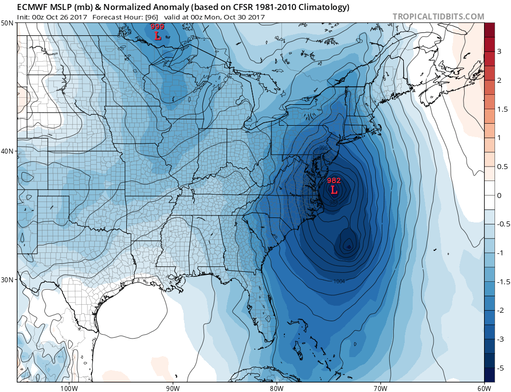
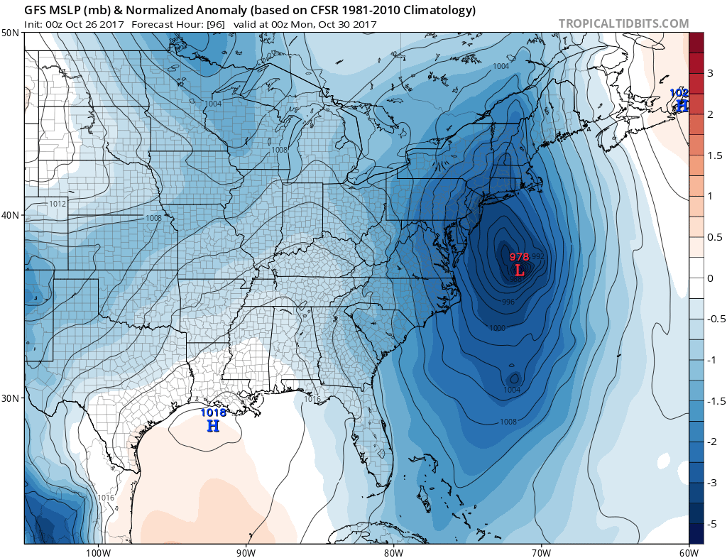
Both the European model and the GFS model show a powerful storm Sunday evening with the European about 60 to 90 miles to the west of the GFS. This system will have some of its roots from a tropical system that will develop in the Northwest Caribbean on Friday and Saturday before it gets absorbed by low pressure that develops off the Southeast US coast. Heavy rain would be a given from this though it will be moving rather quickly.
GFS RAINFALL FORECAST
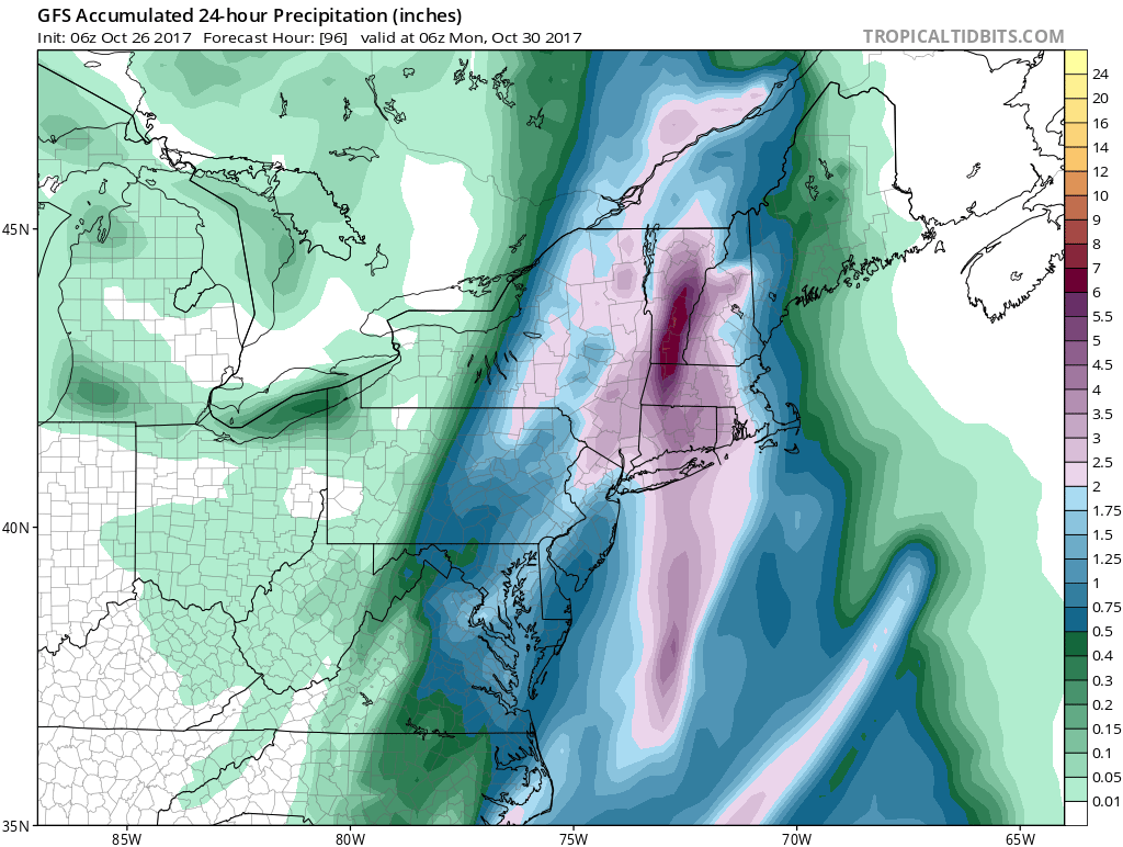
Track is going to be key to outcome for wind and rain obviously. The European has the far more problematic track as it moves it northward right along the immediate coast with a wider area of 2 to 4 inch rains. As far as the wind is concerned, this may be more of an issues after the low goes by and winds shift to the northwest. The winds may actually wind up being stronger after the low goes to our north rather than before though there will be gales developing during Sunday from the Southeast and east before going around to the northwest Sunday night.
We will expand more on this later today as the new model run cycle begins in a few hours.
 GET JOE A CIGAR IF YOU LIKE

FiOS1 News Weather Forecast For Long Island
FiOS1 News Weather Forecast For New Jersey
FiOS1 News Weather Forecast For Hudson Valley


