Weather Models Frigid Indecisive About Snow Chances
Weather Models Frigid Indecisive About Snow Chances
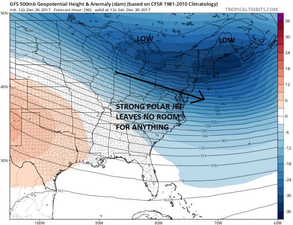
With the mother load of cold air spreading across the Eastern US over the next week or so, the question of snow is a rather confusing one. Weather models are displaying a certain sense of indecisiveness for a number of reasons. The main reason is that you have a hugely strong polar jet stream that is so dominant that there is little room for weather systems to develop in any important way.
EUROPEAN MODEL FRIDAY DECEMBER 29 2017
The European model as well as the GFS & Canadian models and for that matter the NAM model all have this upper air look through Friday morning. The polar jet is dominating everything and while there are disturbances moving along it, there is no room for development. The disturbance in the Northern Plains has a chance to bring some snow here on Saturday but not all models agree with this idea. The European & the Canadian model offer the most bullish view on this.
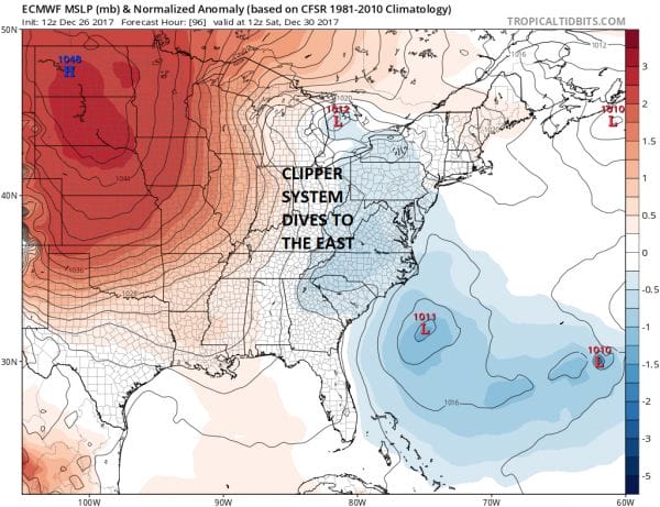
EUROPEAN MODEL SATURDAY MORNING DECEMBER 30
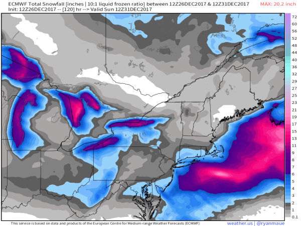
The European model strengthens the trough as it swings east with the bulk of the development well offshore but it still digs far enough west to produce some snow here Saturday. With bitter cold air this is likely to have snow rations of 15-20 or even 20-1. The graphics below are courtesy of WX.GRAPHICS.
REMEMBER FOLKS WEATHER MODELS ARE TOOLS AND NOT FORECASTS
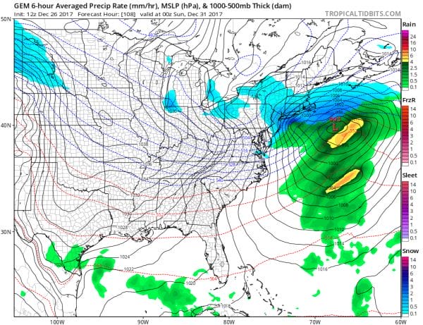
The Canadian model has the most extreme view on the snow side as it has a deeper trough further left with much more development.
CANADIAN MODEL SATURDAY EVENING DECEMBER 30
The GFS on the other hand has the polar jet the strongest and leaves the least amount of room for anything of consequence to happen.
GFS & EUROPEAN WEATHER MODELS SATURDAY DECEMBER 30
The GFS model stretches the vortex east west like a piece of sausage which creates a strong northwest flow and no room. The Canadian & European model are very similar where they develop one vortex to the north and rotate an arm around it and bring it to the coast. That is the main difference regarding a threat for some snow Saturday. Which model is handling the cold air better? If the Canadian & European weather models are correct we could see snow here Saturday into Saturday night with temperatures in the teens and low 20s. If the GFS is right, we would probably see clouds and not much else with temperatures also in the cold upper teens and lower 20s.
Either way which ever model you choose it remains bitter cold into much of next week with temperatures not forecast to go above freezing until at the earliest late next week. The GFS actually holds on to the cold longer before telegraphing a moderating trend developing in the longer term. We will ignore that for now and wait and see how models handle this first system for Saturday. New Years Eve will be very cold with the new year arriving with temperatures in the teens and single digits.
MANY THANKS TO TROPICAL TIDBITS FOR THE WONDERFUL USE OF THE MAPS
GET JOE A CIGAR IF YOU LIKE!
FiOS1 News Weather Forecast For Long Island
FiOS1 News Weather Forecast For New Jersey
FiOS1 News Weather Forecast For Hudson Valley
NATIONAL WEATHER SERVICE SNOW FORECASTS
LATEST JOESTRADAMUS ON THE LONG RANGE
Weather App
Don’t be without Meteorologist Joe Cioffi’s weather app. It is really a meteorologist app because you get my forecasts and my analysis and not some automated computer generated forecast based on the GFS model. This is why your app forecast changes every 6 hours. It is model driven with no human input at all. It gives you an icon, a temperature and no insight whatsoever.
It is a complete weather app to suit your forecast needs. All the weather information you need is right on your phone. Android or I-phone, use it to keep track of all the latest weather information and forecasts. This weather app is also free of advertising so you don’t have to worry about security issues with your device. An accurate forecast and no worries that your device is being compromised.
Use it in conjunction with my website and my facebook and twitter and you have complete weather coverage of all the latest weather and the long range outlook. The website has been redone and upgraded. Its easy to use and everything is archived so you can see how well Joe does or doesn’t do when it comes to forecasts and outlooks.
Just click on the google play button or the apple store button on the sidebar for my app which is on My Weather Concierge. Download the app for free. Subscribe to my forecasts on an ad free environment for just 99 cents a month.
Get my forecasts in the palm of your hand for less than the cost of a cup of Joe!


