
Weather Model Data Show Slow Change Coming
Weather model data today is continuing to confirm what models have been indicating for awhile and that a VERY SLOW pattern change across North America will probably get underway in about a week or two and it will probably take several weeks to play out to see where we wind up come early January. Like hunting or fishing, this is a process that requires patience. This is what I am thinking right now. The process will probably mean that we will transition to a pattern that is a bit more seasonal with a very active fire hose subtropical jet. Storm after storm will begin crashing into the Pacific west. I think initially storms will probably cut to the west of us which means that we will probably see a few events where temperatures warm up to the 50s and 60s before each cold front moves through. Each storm will bring in a little more cold air. Then as we head to New Years and beyond we should wind up wherever it is we are going to wind up. Remember folks, the pattern can change from ridge in the west/trough in the east to trough more in the middle or around 90 degrees west longitude and it will still not be favorable for prolonged cold or snow (if that’s what you are looking for). Like last year the pattern changed from a warm December to one that storms cut to the west for a few weeks with transient cold air. And there is no guarantee that it will morph into a pattern you don’t like.

First off this takes us to December 17th. The NAO (North Atlantic Oscillation) is forecast to move toward a more neutral position. This would signal a slightly less progressive (west to east pattern) but not blocky through mid month. The EPO index also will move toward a more neutral to slightly positive position after peaking again late next week. The PNA or Pacific North America pattern which when positive signals cold trends from negative to closer to neutral. We obviously don’t know what happens beyond the this period other than to guess however weather model data from other long range models do suggest that the downtrends in the NAO and EPO should continue (at least that was the story overnight) and the PNA would trend positive.
Remember folks patterns rarely change on a dime. It is usually a process. My experience over the years is that it usually happens in mid December to Early January. Where we wind up is anyone’s guess so we will watch and wait and observe. While we are in the transition process it is always possible for something out of the ordinary to happen but that is a super short term issue and not a longer term one.
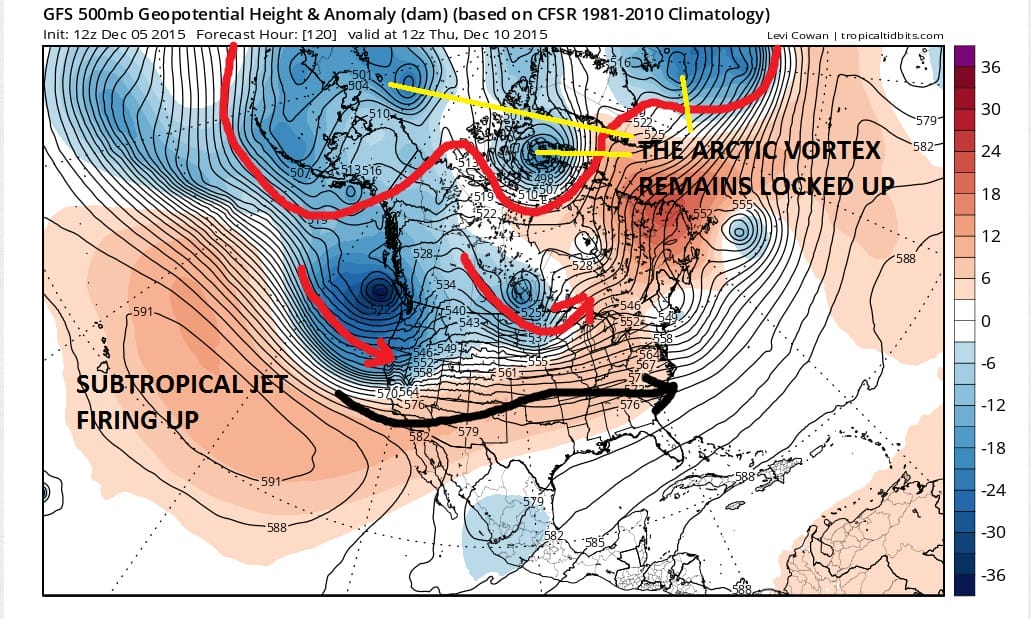
We will begin with today’s day run GFS which is at day 5 which is Thursday Morning 12/10/15. Not too much is different here. We have the vortexes in the Arctic still locked up pretty solidly. The Pacific subtropical jet remains strong and getting stronger. The flow across the United States is pretty much west to east. The ridge in the east at this point is flat. A powerhouse is coming into the west and this will probably cause the ridge in the east to pop again.

Now going into next weekend up comes the ridge which makes sense because the trough coming into the Pacific digs down as they all have. While the polar vortex pattern remains there is some change over Eastern Greenland as a ridge begins to build there. So far we don’t see much which is no surprise since we are only at December 12th. Here is what the surface map is forecast to look like on 12/12/15

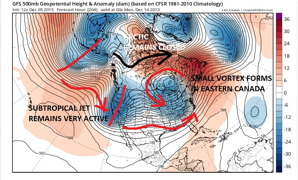
Now let’s continue along. Moving into Monday 12/14/2014 we begin to see a few things happening and it is consistent with the last several runs of the GFS so confidence in this idea grows a bit. While the Arctic remains essentially cut off a small vortex does form in Eastern Canada which is something that has not happened in the last 6 weeks. The subtropical jet continues to work overtime with another deep trough in the west however that trough will not shoot up the ridge in the east like the one before it. The presence of the little vortex will prevent this from happening at least initially. Some cold air will be produced from this but it will be cyclonic in nature and not truly cold air. But it is is a major difference from the past number of weeks.
Here is the corresponding surface map for that look (off by 12 hours). The dash blue lines would symbolize cold air cold enough to snow in. This suggests back to normal temperatures.

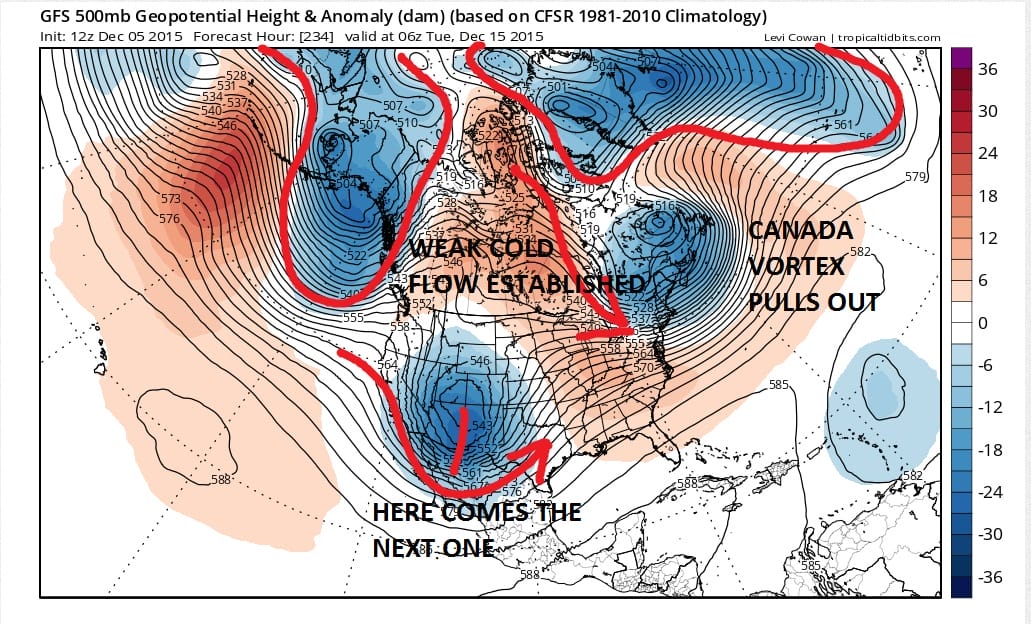
Notice the next storm already pounding the northern Rockies. The big difference with this one is that it has something ahead of it that is going to mean a track further east intially before turning northeast. Again the expectation is that it will cut west as the vortex in Canada starts to pull out to the east. Indeed as we move into day 10 this is what happens.
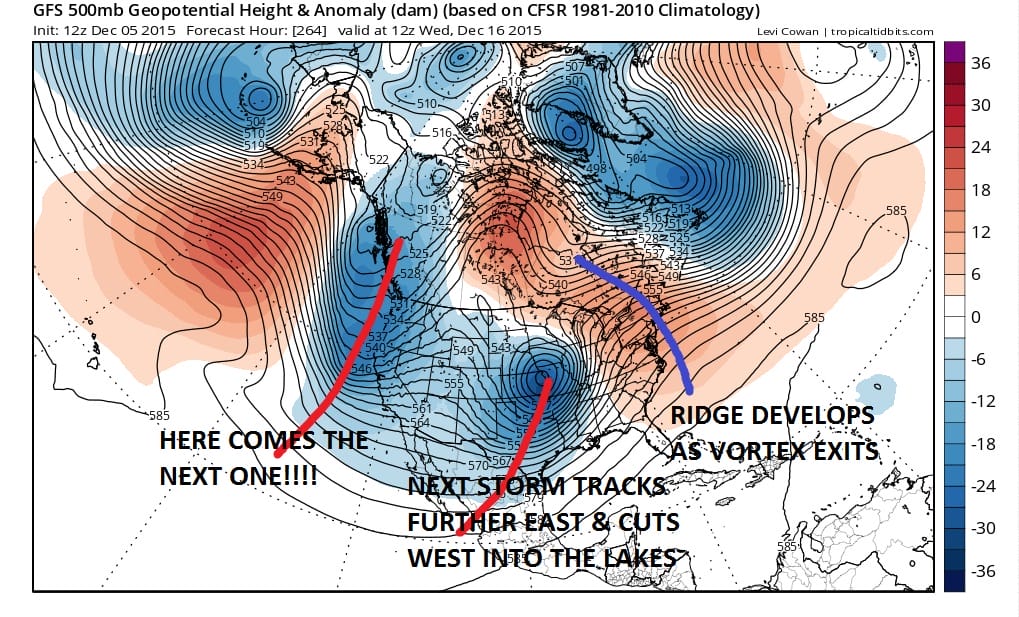
On to day 12 and everything is moving according to plan. The vortex pulls out allowing a ridge to develop in the east but this is not the same kind of ridge like the previous ones in that it is forming further east than the others as the next storm to the west gets ready to intensify and head to the Western Great Lakes.
Now as we keep going we are really past the point where the models are reliable with the specifics so It is hard to really get a grasp on what reality is here. This is likely to be different on the runs that follow. The next Pacific trough comes in and at first glance we seem to have gone back to what we have been in as the ridge flies up in the east. The storm above that cuts to the Great Lakes doesn’t form into a vortex but instead weakens so the ridge pops up right away.
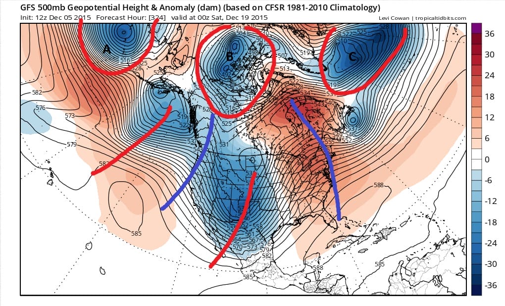
However the model beings to split the vortexes in the Arctic and Northern Canada and that is a big question in the super long term. Is that vortex split correct? Beyond this period at the end of the run we have this.
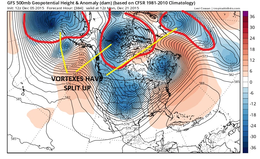
So now we are approaching the week before Christmas. Again beyond the 10 day mode things are very speculative obviously. However I think the general idea is that we are at the beginning of a long process of change that will take a few weeks to play itself through. These models will change on the specifics from run to run. Where we wind up I have no idea. But the adventure getting there will as always be nail biting as it plays itself out. Remember there is no guarantee the pattern we gravitate to is a pattern you will necessarily like. Meanwhile enjoy your afternoon of sunshine and check your local forecast.
JOESTRADAMUS SATURDAY MORNING FORECAST ANALYSIS
SNOW CONTINUES IN THE WEST BUT IS LACKING IN THE EAST OVER THE NEXT 10 DAYS…SKIING OUTLOOK