
Weather Forecasting Models: The JOESTRADAMUS Adventure Continues
Overnight model runs are showing a bit of a shift in the longer term and the question is going to be whether this is something that is transient in nature or is it something that will set up for a short period of time and then revert back to what has been a dominant pattern for much of the last month and a half.

Temporary pattern changes do occur even in the most dominant patterns that establish themselves. In a way the pattern temporarily exhausts itself only to reload and redevelop again after a week or so. You probably have to assume that is the case unless you begin to see evidence that it is going to be something longer term. My video analysis of last night’s weather forecasting models is below comparing the gfs weather model and the european weather model.
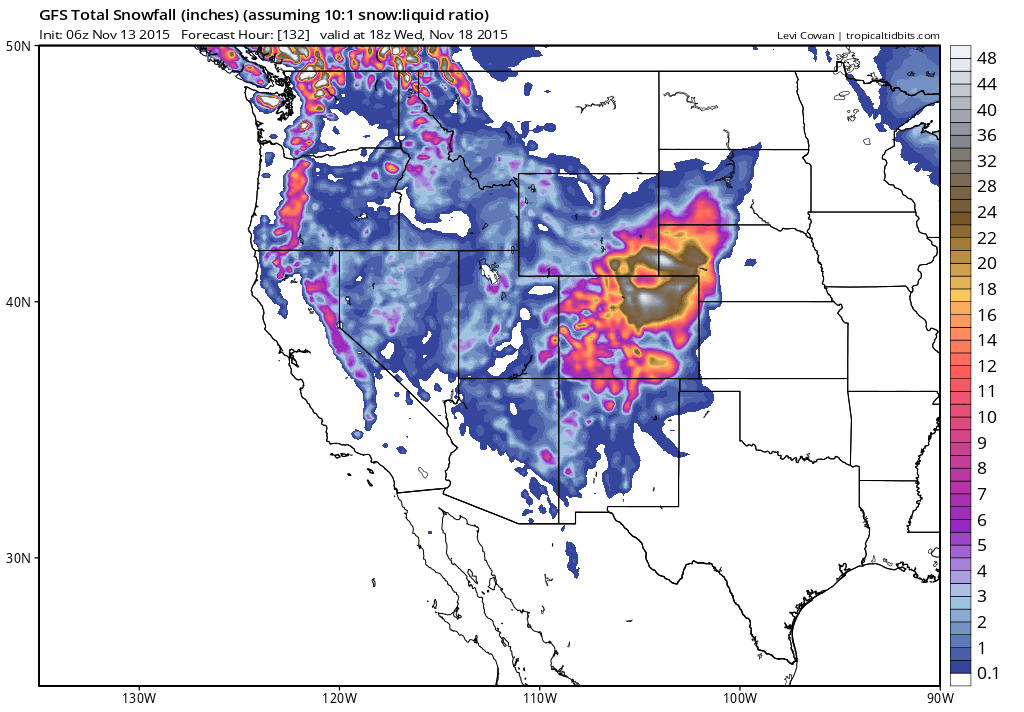
With regards to the snowstorm for the Central Rockies and Central Plains, these storms have been few and far between the last few years and this is looking to be a big one for parts of Colorado and Northwestern Parts of Kansas and Nebraska with 1 to 2 feet of snow likely.
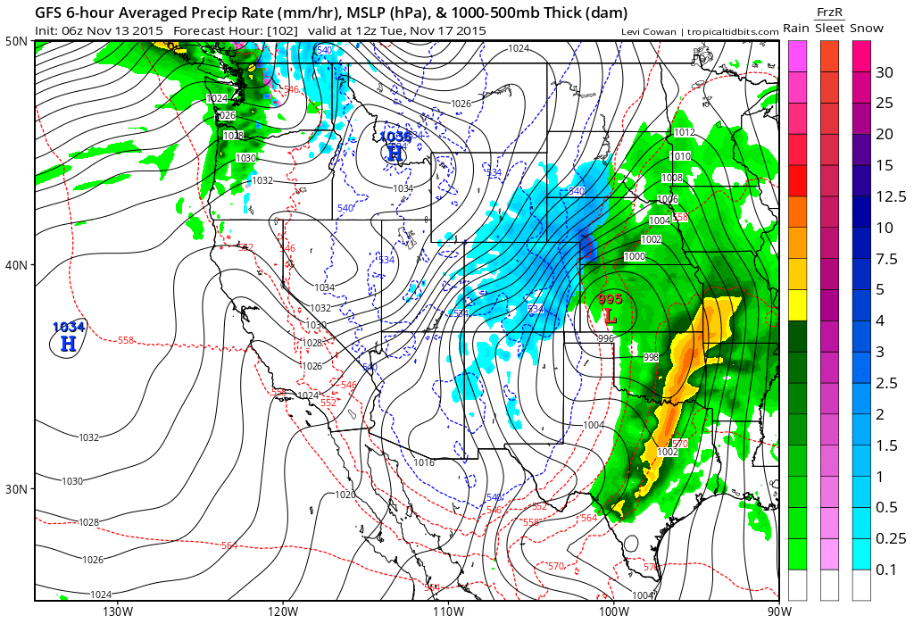
Because of the big ridge located in the Eastern United States the storm will peak out and move north northeast from here so that all that will be left from it for us will be a cold front that approaches late next week with a few showers.
The way I approach the long range is essentially an adventure that you take 4 times a day because as you may have noticed by now there are changes from run to run. You try to look for some sense of consistency between weather models and then try to connect them to past runs and future runs to see if that consistency holds. Not all the weather models went down this road. The Canadian weather model has the ridge in the east back by day 10. It could be just a matter of playing catch up to the others later today or it could be the one that is correct. These are among the many puzzles that forecasters have to work through on a daily basis.
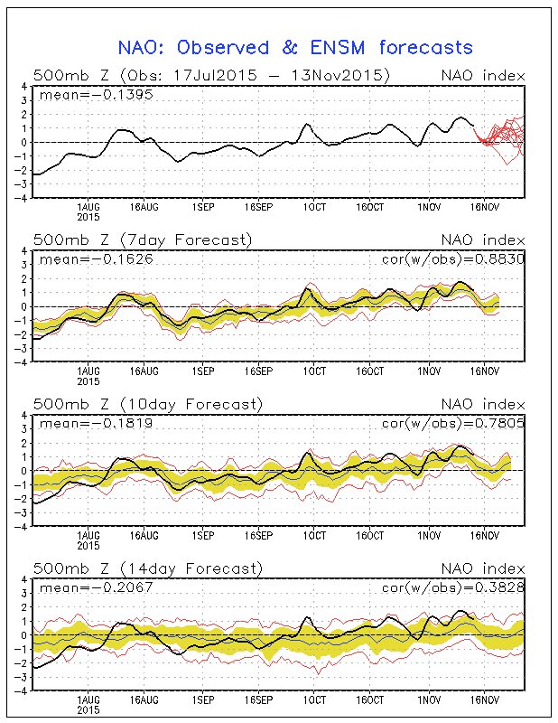

The NAO and AO indictors both bring the index down to the neutral line and then most of the model members bring the indexes positive again. This would lead one to think that the pattern on the weather forecasting models is transient.
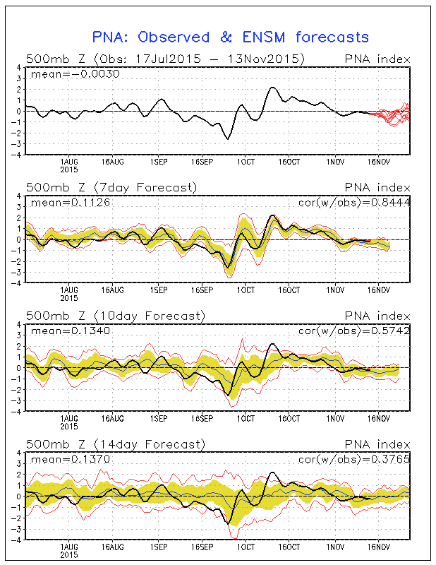
The Pacific North America Pattern indexes straddle the neutral line through the peroid. A positive PNA would favor colder weather in the east. Net Net I would say that perhaps the models suggestion that a gradual move to a more normal pattern is going to happen however it probably also means that storms will continue to track to our west, cutting west of the Appalachians. The positive implications of the NAO/AO would indicating no blocking to speak of. But as I said before we are on an adventure so I will update this later today. Meanwhile we have strong gusty winds and sunshine today as we had back to normal November weather for the next couple of days.
MARINE FORECAST: GALE WARNING IN EFFECT
JETSTREAM VIEW FOR SHORT RANGE (NEXT 6 DAYS)
SHORT TERM FORECAST FOR THURSDAY THROUGH SUNDAY
JOESTRADAMUS LONG TERM FORECAST
JOESTRADAMUS WINTER FORECAST 2015-2016