
Weather Forecast Models Pointing to Temporary Pattern Change
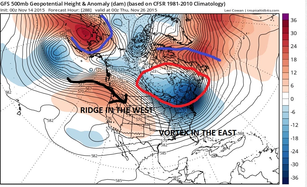
The overnight weather forecast models are coming in and the first in is the GFS model and it remains on course indicating what looks to be a temporary pattern change. For the last several weeks since the cold blast in mid October the east has been dominated by a ridge of high pressure aloft. That ridge has relaxed somewhat this weekend but it plans to flex its muscles again early next week by building up the Eastern seaboard. This is in response to a deep trough in the west which will result in a snowstorm for the Colorado Rockies and parts of the central plains as the snowfall map indicates for the middle of next week.


The ridge in the east is very strong and builds all the way north to far northeastern Canada. To the west of this ridge is the polar vortex which is locked up in Alaska/Siberia and that means cold polar air has no pathway into the Eastern US or even into Central Canada. However once this storm lifts out to the northeast later this week, the first in a series of cold fronts will begin to move through. Each front has progressively colder air. The model tonight strongly indicates a change in the profile across Canada and the far northwest which means that for the first time since mid October, cold air will have a passage way down from the northern latitudes.

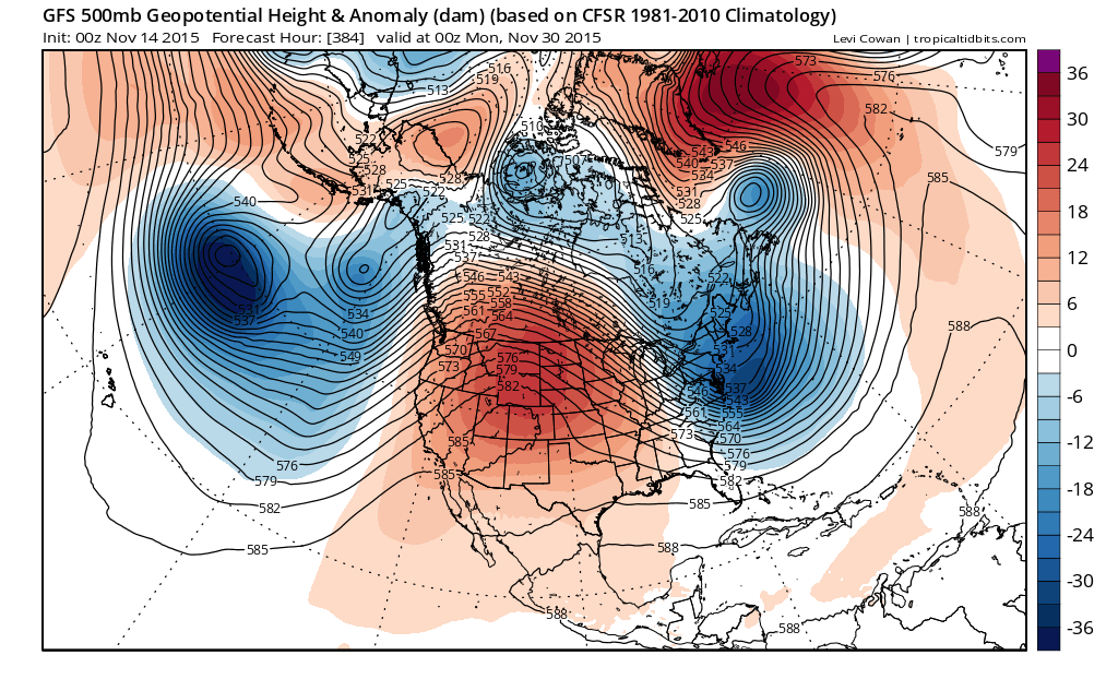
Im jumping now to day 10 which takes us into next Sunday night. The polar vortex has shifted eastward and we now have a strengthening northwest flow out of Canada into the Northern Plains and Western Great Lakes. Ridges are strengthening on either side of this vortex. Cold air will be moving southward into the Continental US during Thanksgiving week. The trough position is initially pretty far west but each disturbance that moves along it will shift the trough and cold air axis further east. This at least implies a return to normal temperatures and also would indicate at least 1 shot of cold air that will bring below normal temperatures into the east over time.
Now lets jump to Thanksgiving eve where the vortex actually drops pretty far south into Southeastern Canada. This would be a very strong shot of cold air for this time of year. Blocking highs are set up over Western Alaska keeping the Pacific jet stream pretty far south in a split flow there while a strong ridge in the Atlantic wraps around the vortex into far Northeastern Canada.
Now this is all fine and dandy for cold weather lovers. Of course we know this is going to change on the next run to some degree if not a large degree however unless something truly radical happens the idea of a colder look seems to be on course. The big question really is whether this is transitory. Does the vortex pull out to the east and lift up and out allowing the ridge in the east to eventually rebuild or is there room for the vortex to reform westward and rotate around again?
The GFS at day 16 which is the last day of the month still looks blocky enough at the high latitudes to suggest that there is room for this cold air to last into early December. However I can also envision how this vortex could lift out enough to allow the ridge to build back in. One good sign for cold air lovers is that there doesn’t seem to be any indication of the dominate vortex reforming in the Alaska/Siberia region by the end of the month. This is key. The model may be indicating a split in the vortex which would be indicative of the North Atlantic Oscillation flexing some muscle here. The ensembles on Friday showed some of the member models going negative on the index and staying there while most of them went positive again at the end of the month signalling a breakdown in blocking. Perhaps the GFS is telling us that the minority models may be winning this argument.
I’m not sold on all of this yet. The change to the colder look into day 10 is consistent with day run models as well as the European Model (which only goes out 10 days). Of course this is just one model. We will have the others later this morning and I will look at those during the morning and see where they take us. I would not draw any final conclusions based on this run by any means but it is an interesting solution going forward.
FRIDAY’S LONG RANGE MODEL DISCUSSION
FRIDAY MORNING’S VIDEO ANALYSIS