DOWNLOAD MY NEW FREE JOESTRADAMUS WEATHER APP FOR ALL DEVICES
Washout Sunday Rain Flood Watch Continues
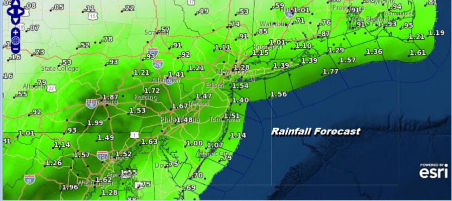
We are socked in with clouds as the satellite picture shows this morning. The entire day is shot as we watch low pressure slowly move through North Carolina and then off the coast later today. It is moving at a snails pace which keeps us in rain all day long. In fact it seems this low is taking longer and longer to get out of the way and we may have to wait until after dark for rains to end from west to east late this evening.
SATELLITE

REGIONAL RADAR

We are seeing solid coverage of rain on the regional and local radars as the area slides to the northeast. There are some areas of moderate rain embedded in the mix but we don’t see any torrential rains or thunderstorms. This is really all about a miserable day of steady rain and raw conditions with temperatures holding in the 50s all day long.
LOCAL RADAR NEW YORK CITY

LOCAL RADAR PHILADELPHIA


We at least have bettern weather to look forward to for Monday into Tuesday of the new week. Sunshine returns Monday and temperatures will respond nicely by reaching the 70s in most areas and even along the coast temperatures will reach the 60s to near 70. Tuesday we will see sun and arriving clouds as a cold front approaches and there could be a late shower or thunderstorm. We will see highs reach the mid 70s to lower 80s on Tuesday before the front passes.

Wednesday begins the next round of an onshore flow and low pressure coming out of the Plains and headed into the Great Lakes. It appears likely that we will be in clouds Wednesday with temperatures back in the 50s to near 60. Then the next warm front cold front combination begins Thursday with showers moving in and the chance for showers and thunderstorms on Friday. Warmer temperatures are likely late in the week with this low headed to the west. If things move along we might see a nice Mother’s Day weekend.
MANY THANKS TO TROPICAL TIDBITS FOR THE USE OF MAPS
Please note that with regards to any tropical storms or hurricanes, should a storm be threatening, please consult your local National Weather Service office or your local government officials about what action you should be taking to protect life and property.


