Warmer Temperatures Start The Week
Cold Front Arrives Wednesday Night Into Thursday
The work week begins with the onshore flow gone. A cold front has passed off shore. What is left is a quiet nearly cloud free satellite loop across much of the Northeast and Middle Atlantic states. The curse of the onshore flow has been broken, at least for awhile. Skies today will be partly to mostly sunny. Since we do not have any real cold air to speak of in the US and especially here in the Eastern US, temperatures this afternoon should rise nicely reaching the upper 60s and even some lower 70s. The only exception will be south and east facing shorelines that will have to deal with a wind off the cold ocean and lower highs this afternoon.
SATELLITE WITH LIGHTNING STRIKES
WEATHER RADAR
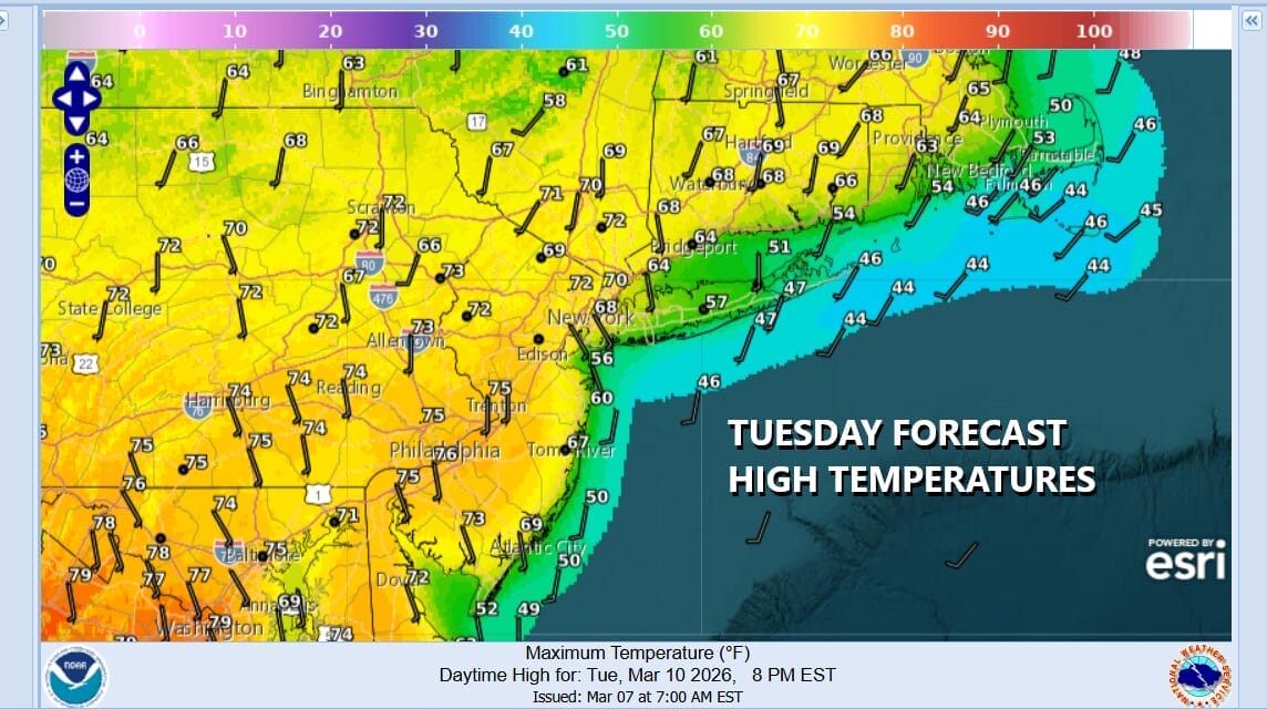
Nights are warming up as well and with nothing more than some passing clouds tonight, and maybe a little localized fog, overnight lows will be mostly in the 40s. This sets up for a warm Tuesday. Away from the coast and with plenty of sunshine, highs will reach the low and middle 70s. However winds will be south southeast Tuesday so coastal counties of New Jersey, to Long Island and South Coastal New England will be dealing with cooler highs in the 60s and 50s.
We are free of weather front issues until late this week as a cold front from a storm system in the Great Lakes begins to push eastward. Like this weekend, the front is likely to produce severe weather over a large portion of the Midwest and Deep South. Also like this weekend, this weather front likely weakens as it approaches the Eastern US come Thursday into Friday.
Wednesday should be no worse than partly sunny and there will be a wide east west spread in temperatures, ranging from the 70s in western areas of New Jersey and Eastern Pennsylvania, to 50s along the immediate coast of New Jersey to Long Island and South Coastal New England with 60s somewhere in between.
There will be some showers and thunderstorms well to our north and west by Wednesday evening but as the front approaches the showers and storms weaken somewhat. We will get into some showers later Wednesday night into Thursday morning but, like the weekend front, I’m not expecting much. Weather conditions will improve and we will see temperatures cool off Thursday and especially Friday when highs will likely be just in the 40s.
BE SURE TO DOWNLOAD THE FREE METEOROLOGIST JOE CIOFFI WEATHER APP &
ANGRY BEN’S FREE WEATHER APP “THE ANGRY WEATHERMAN!
MANY THANKS TO TROPICAL TIDBITS FOR THE USE OF MAPS
Please note that with regards to any severe weather, tropical storms, or hurricanes, should a storm be threatening, please consult your local National Weather Service office or your local government officials about what action you should be taking to protect life and property.