
Warmer More Humid Week Ahead Outlook Watching Southeast US Coast

Weather in 5/Joe & Joe Weather Show Latest Podcast
Warmer More Humid Week Ahead Outlook Watching Southeast US Coast
Warmer and more humid conditions have arrived and we are seeing plenty of sunshine this afternoon. To the north you see a band of east west clouds and that is due to a backdoor cold front that is pushing southward. This sets up severe weather risk in extreme Northern Pennsylvania as well as the Middle and Upper Hudson Valley northward.
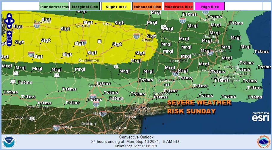
Notice that the general thunderstorm risk cuts off sharply as you head south so there is no thunderstorm risk tonight south and southwest of NYC. The rest of today will be warm and you may have noticed that humidity levels are up today and they will continue to rise for the next few days.
SATELLITE

WEATHER RADAR

The backdoor cold front will make it south to about NYC later Monday or Monday night so you can look forward to a very warm and humid night tonight and a very warm to hot and humid day Monday. Sunshine will take highs to the middle and upper 80s.
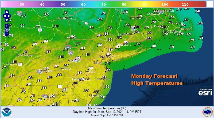
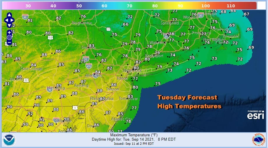
The front won’t be very active so we are not expecting any showers or thunderstorms from it Monday. In fact the front slowly weakens and dissolves though it will mean for slightly lower temperatures Tuesday from NYC north and east, while it will be very warm to hot and humid to the southwest. We should have no worse than partly sunny skies Tuesday.
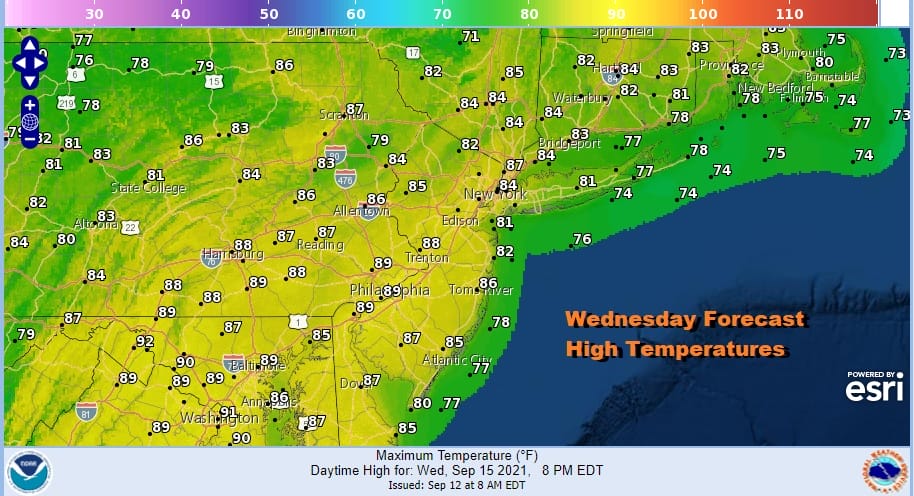
Wednesday sees a slightly stronger cold front approach and with the backdoor front gone, it will be a hot and humid day with sunshine taking highs to the upper 80s and lower 90s with high humidity. Thunderstorms will stay well to the northwest as the front is slowing down and will likely stall out..guess where?
Thursday and Friday outlooks have changed as we have a number of factors in play. It appeared yesterday that a low would form off the Southeast US coast which may or may not become tropical. It seems to be doing it faster on today’s model runs. We also have Tropical Storm Nicholas in the Western Gulf and uncertainty there over track and strength. There are some indications Nicholas could move inland in coastal Texas and that the moisture would spread across the Gulf States and eventually up the East Coast late in the week.
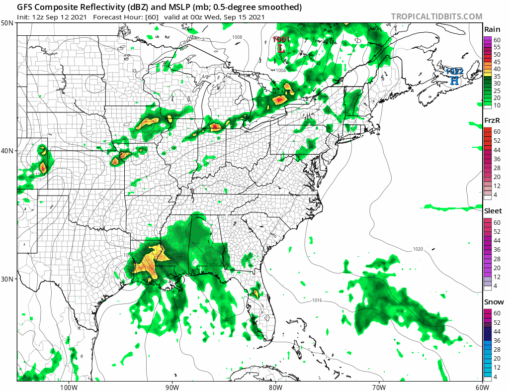
The further east GFS model conflicts with other models which leave the moisture down in the Gulf States. We tend to lean on the idea that stalling front overhead and the low to the south will interact to produce the chance for some showers or downpours Thursday and Friday but we don’t expect widespread rains. It also appears that the likelihood for tropical cyclone development of the low offshore has diminished if it winds up being further north and faster. With regards to the potential for tropical storm development we will continue to take a Switzerland approach and just sit back and wait to see how these chess pieces all play out. Sky conditions Thursday and Friday will be changeable with cloudy to even occasionally partly sunny skies with scattered showers or downpours. It will be very humid with highs in the low to mid 80s both days. We may have to wait until next week (week of Sept 20th) to get some real cold front relief.
BE SURE TO DOWNLOAD THE FREE METEOROLOGIST JOE CIOFFI WEATHER APP &
ANGRY BEN’S FREE WEATHER APP “THE ANGRY WEATHERMAN!

MANY THANKS TO TROPICAL TIDBITS & F5 WEATHER FOR THE USE OF MAPS
Please note that with regards to any severe weather, tropical storms, or hurricanes, should a storm be threatening, please consult your local National Weather Service office or your local government officials about what action you should be taking to protect life and property.


