Warmer Air Tries Pushing East 60s Thursday
Warmer Air Tries Pushing East 60s Thursday
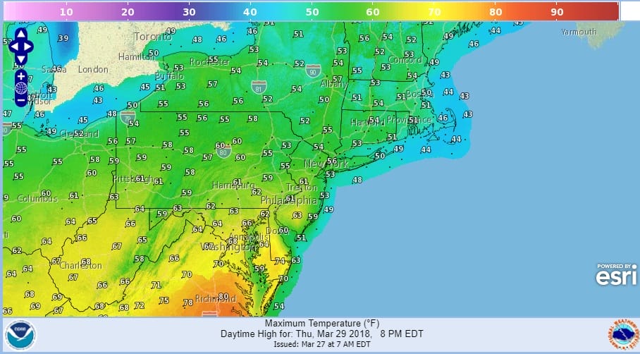
The map above is the forecast high temperature map for Thursday and we can see that the 60s will be trying to move northward. While they make it into Southern New Jersey and Southeastern Pennsylvania they fall short of areas to the north in Northeast Pennsylvania to NYC to Southern New England. The key will be clouds and wind direction. If the sun can manage to break through and the wind direction behaves its self to something more southwest than southeast, then maybe we can push those 60s a bit further to the north.
FRIDAY’S FORECAST HIGH TEMPERATURES
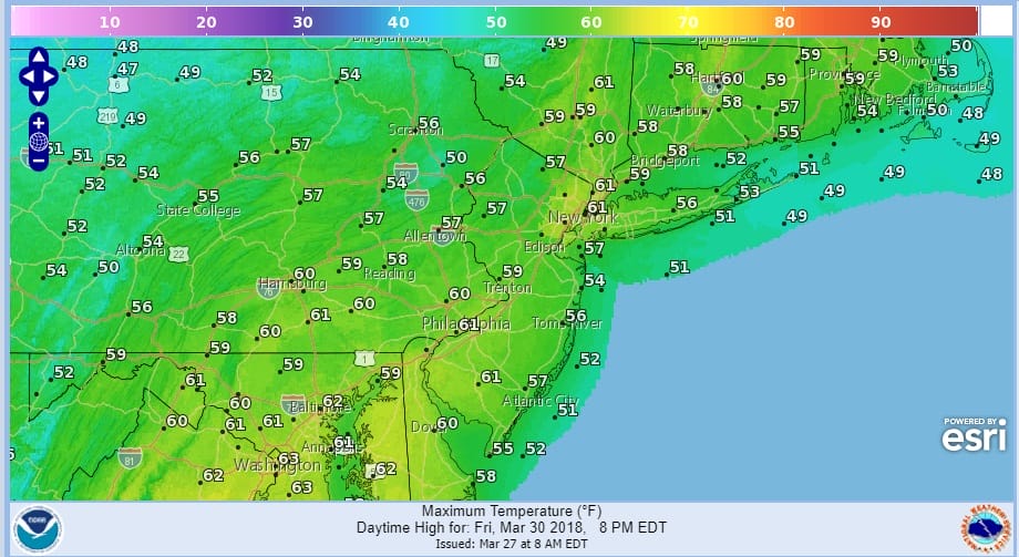
Friday looks to repeat though there might actually be a better chance once the front passes through with some showers into Friday morning and we break out with some sun with a northwest wind. Fingers are crossed for this because we really could use a break in the recent chill.
We are at least starting out with some sunshine today but high clouds are already moving in from the west and they will be increasing and thickening up all day so temperatures will probably be stuck in the 40s and along the coast with an east wind, it may be more like lower 40s.
US SATELLITE

REGIONAL RADAR

Regional radar is showing the leading edge of showers with a warm fron moving into Western Pennsylvania. The bulk of these showers will pass to our north but some could clip us overnight into Wednesday morning. In some of the colder areas north and west of the coast, cold air will become trapped for a short period of time so some pockets of freezing rain/freezing drizzle are possible in Northwest New Jersey, Northeast Pennsylvania into the Hudson Valley but I don’t believe this will reach advisory criteria
LOCAL RADAR NEW YORK CITY

LOCAL RADAR PHILADELPHIA


Wednesday look for lots of clouds and the chance for passing showers as temperatures head up into the 50s especially away from the ocean. Thursday its fingers crossed time for 60s but clouds and then late showers might stall the effort. Showers could last into Friday morning early before we see leftover clouds give way to some sunshine.
The Passover/Easter weekend has some question marks hanging over it as weather models haven’t exactly come to terms with the next cold front. The faster GFS brings another front through here early on Saturday followed by dry air. The European Canadian models stall the front out to some degree leading to complications. I’m not sure what to make of it at this point but for now we will keep the weekend mostly dry with the caveat that this part of the forecast is subject to change.
 GET JOE A CIGAR IF YOU LIKE

FiOS1 News Weather Forecast For Long Island
FiOS1 News Weather Forecast For New Jersey
FiOS1 News Weather Forecast For Hudson Valley


