Warmer Air Into Thursday, Freezing Rain Chance Christmas Eve
Warmer Air Into Thursday, Freezing Rain Chance Christmas Eve
We are beginning to warm up although it might be a little hard to believe. Warm ups come in steps and the first step is tonight. Other than a few clouds this evening skies will clear out tonight and we will see temperatures bottom in the mid teens to mid 20s which is about 10 degrees higher than last nights teens and single digits. Not much happening on the satellite view tonight as we have weak systems moving across the country at the moment. Radars are quiet and should remain so into Thursday morning.


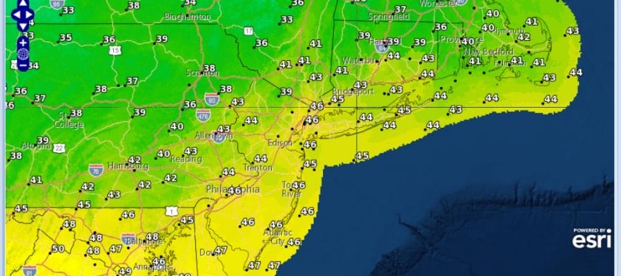
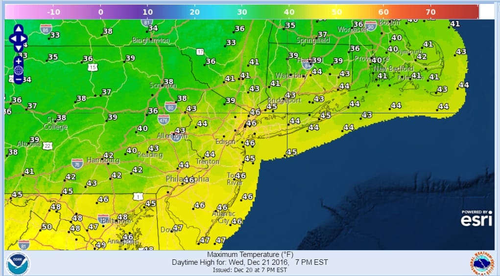
Wednesday looks great with sunshine most of the day and just some high clouds at the end of the day with temperatures warmer, in the low to mid 40s. The next cold front comes through on Thursday with a midday or early afternoon shower or snow shower. Temperatures will be in the 40s. Behind the front is air that slightly cooler but not much cooler so I’m thinking some sunshine and highs in the 40s.
WARMER WEDNESDAY FORECAST HIGHS
Christmas Eve and Chanukah fall on Saturday and we have to watch a weak disturbance coming out of the Ohio Valley. Weather models are weak but the European model brings in a solid quarter to a half inch of rain as colder air bleeds southward from Eastern Canada. This could set up the possibility of some freezing rain or a mix Saturday afternoon and evening away from coastal areas. Other models are less bullish on this idea but I think we have to watch this and see what future runs do with this. Otherwise Christmas Day looks good with clouds and some sun with highs into the 40s.
SNOW REMOVAL COMPANIES FOR YOUR WINTER NEEDS
LONG ISLAND ROCKLAND COUNTY Connecticut

![]()

FiOS1 News Weather Forecast For Long Island
FiOS1 News Weather Forecast For New Jersey
FiOS1 News Weather Forecast For Hudson Valley
NATIONAL WEATHER SERVICE SNOW FORECASTS
LATEST JOESTRADAMUS ON THE LONG RANGE
Weather App

Don’t be without Meteorologist Joe Cioffi’s weather app. It is really a meteorologist app because you get my forecasts and my analysis and not some automated computer generated forecast based on the GFS model. This is why your app forecast changes every 6 hours. It is model driven with no human input at all. It gives you an icon, a temperature and no insight whatsoever.
It is a complete weather app to suit your forecast needs. All the weather information you need is right on your phone. Android or I-phone, use it to keep track of all the latest weather information and forecasts. This weather app is also free of advertising so you don’t have to worry about security issues with your device. An accurate forecast and no worries that your device is being compromised.
Use it in conjunction with my website and my facebook and twitter and you have complete weather coverage of all the latest weather and the long range outlook. The website has been redone and upgraded. Its easy to use and everything is archived so you can see how well Joe does or doesn’t do when it comes to forecasts and outlooks.
Just click on the google play button or the apple store button on the sidebar for my app which is on My Weather Concierge. Download the app for free. Subscribe to my forecasts on an ad free environment for just 99 cents a month.
Get my forecasts in the palm of your hand for less than the cost of a cup of Joe!


