Warm Weekend Showers Late Sunday New Year’s Eve New Year’s Day Outlook
One of the downsides of this time of year is that when we are on the warm side of normal, it usually comes with cloud issues and it does tend to keep things rather gray and dismal looking. We do have clouds around today as we wait for a weak cold front to move through. The front doesn’t have much with it other than some scattered showers that are showing up on the regional radar. Much of that shower activity is likely to weaken as it moves eastward into this afternoon. Temperatures should make it up into the upper 40s and lower 50s in most places since we really don’t have far to go from the lows of this morning.
SATELLITE

REGIONAL RADAR

Once the front weakens enough and moves through winds will pick up from the northwest this afternoon and we should see improving weather conditions with maybe some break in the cloud cover from west to east late today. Skies should clear out tonight with most lows in the 30s.
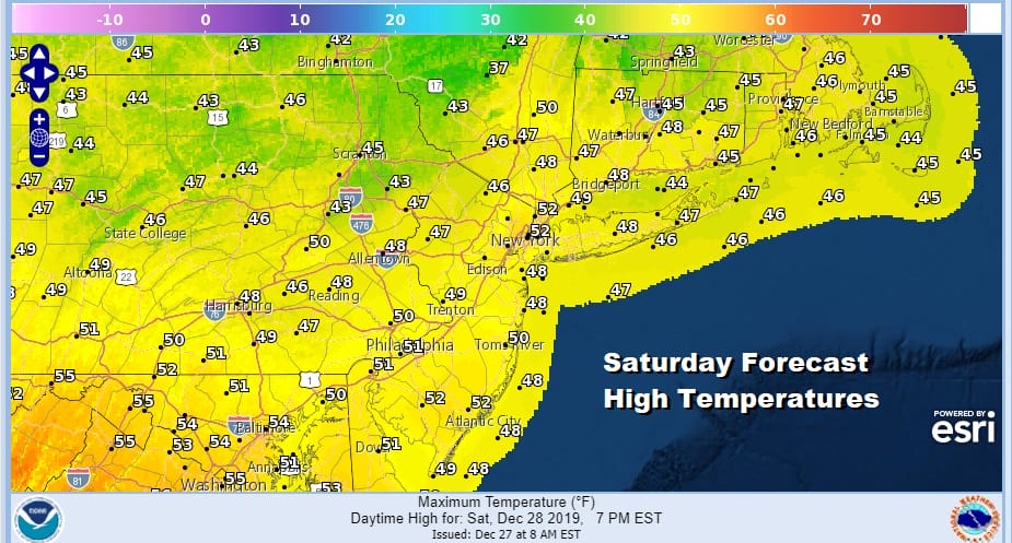
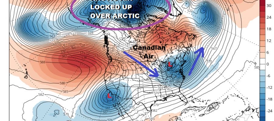
Saturday will be the better of the two weekend days. We should see a good deal of sunshine with highs reaching into the 50s in many areas. Then clouds will arrive late Saturday night as we set up for showers on Sunday. Low pressure in the Southwest US will be heading northeast into the Northern Plains. What cold air there is, it is located in the Western half of the US. Arctic air is mostly cut off from the US at least for now. This sets us up for showers coming in later Sunday night afternoon with some heavier rain Sunday night into Monday morning.
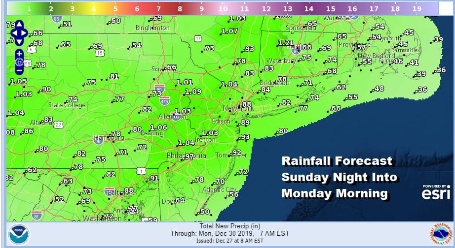
Rainfall amounts of three quarters of an inch to an inch or so seem most likely. This storm will park itelf over the Great Lakes and gradually redevelop to the east Monday and Tuesday. This will likely mean only slow improvement in weather conditions. Showers could linger into Monday afternoon. Drier air is poised to move in for Tuesday and Wednesday though it will be on the breezy side. New Years Eve poses no weather issues with clouds and some sun returning with temperatures in the 40s. New Year’s Day looks dry and breezy as well with sunshine and highs in the upper 30s and lower 40s.
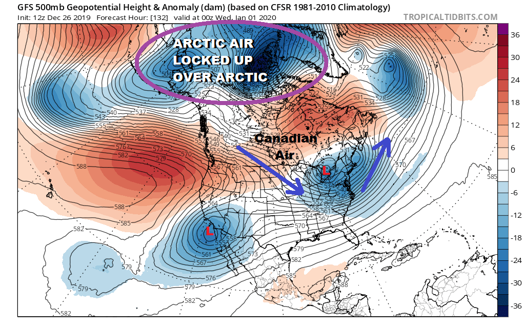
As far as the long range is concerned we are beginning to see some signs of change as we head into January. Arctic air is locked up in Canada due to the position of the Polar Vortex over and north of Alaska. This locks up the cold so that it barely bleeds southward into Canada let alone the US. However overnight weather models show that vortex being dislodged early next week with the jet stream establishing what i call a Canadian connection.
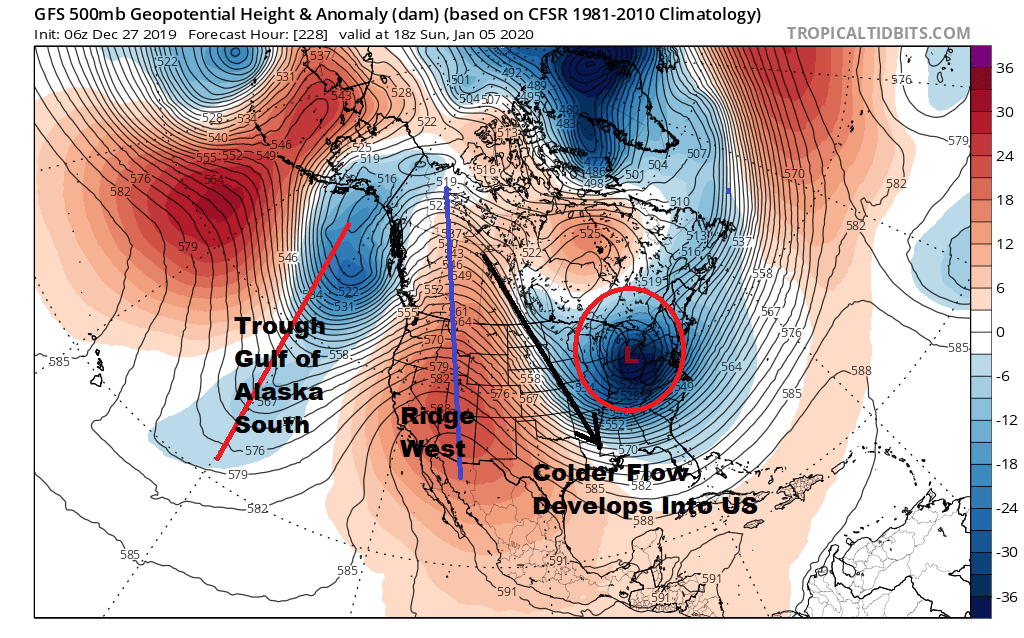
Weather models have been pointing to the January 5-6 time frame for something to happen though what it will be remains to be seen. The colder look does develop but whether it hangs around for more than a few days remains to be seen. This would line up with the 2-3 weeks active cold/week-10 days inactive/mild pattern that we have been in since mid October. We will have more on the long range this evening on the Joe & Joe Weather Show at 7pm on my YOUTUBE channel or you can watch it on the free weather apps.
BE SURE TO DOWNLOAD THE FREE METEOROLOGIST JOE CIOFFI WEATHER APP &
ANGRY BEN’S FREE WEATHER APP “THE ANGRY WEATHERMAN!
MANY THANKS TO TROPICAL TIDBITS FOR THE USE OF MAPS
Please note that with regards to any severe weather, tropical storms, or hurricanes, should a storm be threatening, please consult your local National Weather Service office or your local government officials about what action you should be taking to protect life and property.


