Warm Tuesday Highs in the 80s Slow Cool Down Next Few Days
Showers Thunderstorms Saturday
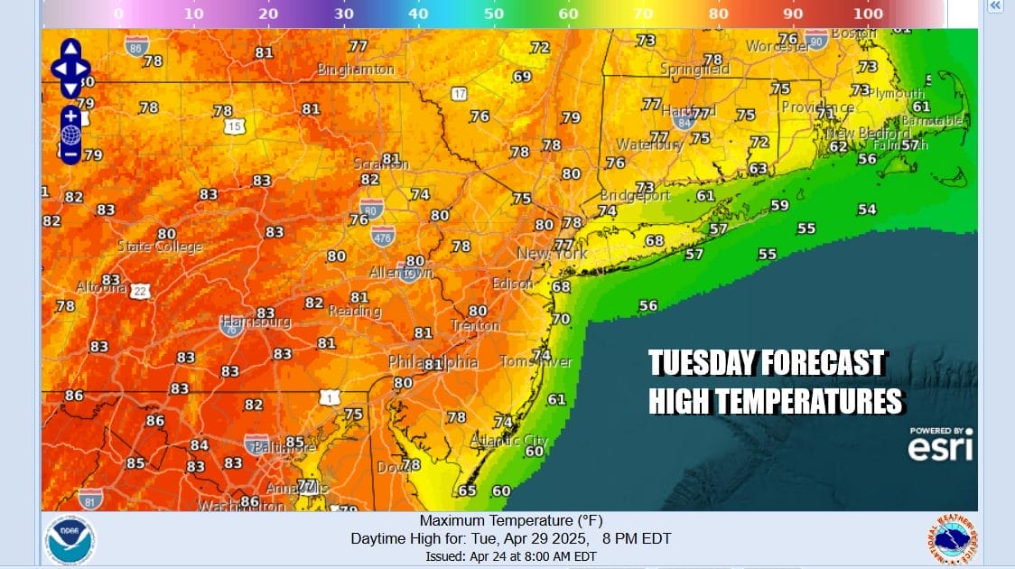
Today looks to be the warmest day of the week across Eastern Pennsylvania to Southern New England including new Jersey and Long Island. We have a cold front well to the northwest today and high pressure to the southeast. This puts us in a zone of west to southwest winds. We will have no worse than partly sunny skies today and temperatures will warm into the 80s inland. Cooling sea breezes will develop along south and east facing shorelines so temperatures in the se coastal areas will be at least 10 to 15 degrees cooler.
SATELLITE WITH LIGHTNING STRIKES
WEATHER RADAR
This cold front will be producing showers, thunderstorms, and severe weather across Western New York and Western Pennsylvania later today and tonight thanks to all the daytime heating and a developing unstable atmosphere. However the cold fromt will weaken as it heads eastward and you can see that the thunderstorm clusters that develop today gradually fall apart overnight as they head eastward.
Most lows tonight will be in the mid 50s to lower 60s with some clouds around. Wednesday will be a slightly cooler day as there will be some leftover warm air around and air behind the front is not especially cool. Look for skies to become partly sunny Wednesday with temperatures that will be topping out in the mid 70s to around 80 degrees in some of the warm spots.
We are going to see slightly cooler temperatures Thursday and Friday but both days should be dry. Skies will be no worse than partly sunny both days with highs in the 70s. Cooler 60s and sea breezes will be an issue along the coast. Then we move to the weekend where low pressure heads from the Great Lakes to New England. The trailing front is likely to set off showers and thunderstorms during Saturday and there could be the risk for some isolated severe thunderstorms. Sunday appears to be a cooler drier day.
BE SURE TO DOWNLOAD THE FREE METEOROLOGIST JOE CIOFFI WEATHER APP &
ANGRY BEN’S FREE WEATHER APP “THE ANGRY WEATHERMAN!
MANY THANKS TO TROPICAL TIDBITS FOR THE USE OF MAPS
Please note that with regards to any severe weather, tropical storms, or hurricanes, should a storm be threatening, please consult your local National Weather Service office or your local government officials about what action you should be taking to protect life and property.