Warm Tuesday Ahead of Severe Weather Risk Wednesday
Watching Developing Atlantic Low

Weather in 5/Joe & Joe Weather Show Latest Podcast
Warm Tuesday Ahead of Severe Weather Risk Wednesday Watching Developing Atlantic Low
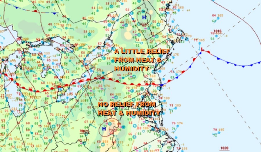
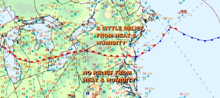
A stalled front lies east west across the middle of New Jersey and Pennsylvania and this means that there will be two worlds of temperature and humidity conditions today. We will settle on the idea that most areas will see partly sunny skies. There isn’t much with the front. Afternoon shower and thunderstorm chances are very low and not worth throwing into the forecast.
Where you are with respect to that east west cold front determines your highs and relative humidity. North of the front and you will see highs today in the upper 70s to around 80 or so. That covers Northern New Jersey to the Hudson Valley and Southern New England. If you are south of the front you will be very warm and humid with highs in the upper 80s to around or just over 90 degrees with high humidity. The satellite pictures and loops this morning don’t really show much going on.
SATELLITE

There are some leftover light showers moving through Southern New England and Long Island but elsewhere the radars are generally quiet and these echoes will disappear as we move through morning hours.
WEATHER RADAR


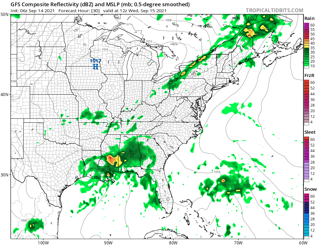
That front backs up northward tonight so it is back to very warm to hot conditions for Wednesday and we have a stronger cold front coming in from the northwest which sets up severe weather risk. The Storm Prediction Center continues to show a slight risk for severe weather mainly inland Southwest Pennsylvania northeast into Northeast New England!
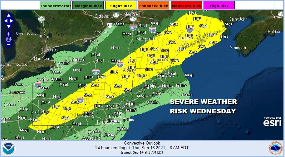
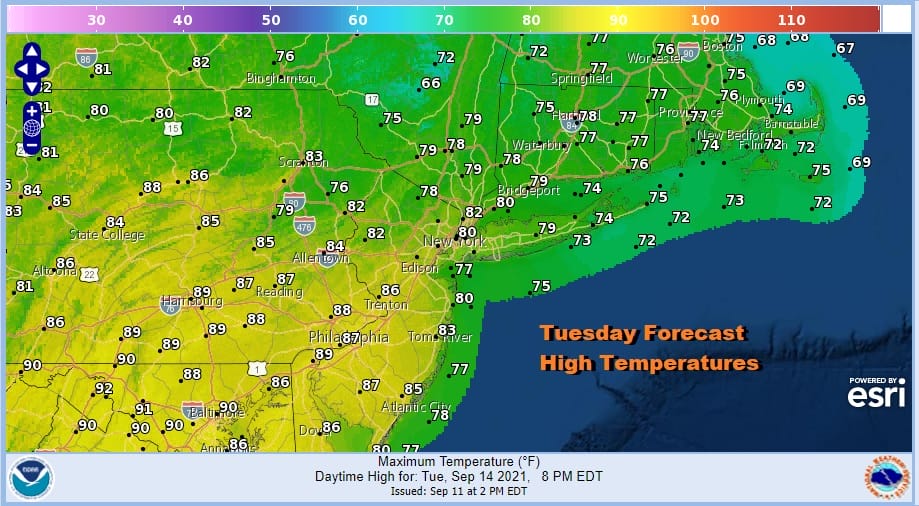
Ahead of Wednesday’s cold front highs will be in the mid 80s to near 90 degrees. It will be very warm and very humid so the atmosphere will be unstable. It appears that the vast majority of these thunderstorms will be inland. As the front moves eastward it will approach the coast, slow down, and as so many fronts have done this summer, stall out nearby.
This leaves us in the land of uncertainty for Thursday and Friday. Then attention will be focused on low pressure that begins to develop off the Southeast US coast and moves northward. We are noticing on the satellite pictures and loops this morning that disturbed weather is showing some signs of organization to the east of the Bahamas. There are a number of questions here. Moisture from the remnants of Hurricane Nicholas seems to get spent out across the south so aren’t really concerend about that. The stalled front along the coast will likely leave us in clouds Thursday and Friday with high humidity and the chance for showers. Does this low develop into something tropical? That certainly could change the dynamic for Thursday and Friday forecast so this is the big unknown at the moment. The National Hurricane Center indicates a 60% chance of a tropical cyclone forming. Most model tracks are offshore which is a plus and some models are more developed than others. For now we will call for clouds and for showers running around Thursday and Friday and look for some improvement over the weekend. Patreon members can look for additional posts regarding this later today.
BE SURE TO DOWNLOAD THE FREE METEOROLOGIST JOE CIOFFI WEATHER APP &
ANGRY BEN’S FREE WEATHER APP “THE ANGRY WEATHERMAN!

MANY THANKS TO TROPICAL TIDBITS & F5 WEATHER FOR THE USE OF MAPS
Please note that with regards to any severe weather, tropical storms, or hurricanes, should a storm be threatening, please consult your local National Weather Service office or your local government officials about what action you should be taking to protect life and property.


