Warm Humid Next Few Days Showers Late Thursday
Warm Humid Next Few Days Showers Late Thursday
The next two days we are going to see warm and somewhat humid conditions overtake us but this is not the dead of summer so it is a bit easier to take It is also not going to 90 degrees which makes a difference as well. The satellite loop this morning still shows the three system triangle with one southeast of Nova Scotia, the remnant low of Irma in the Tennessee Valley and Jose between the Bahamas and Bermuda. We are still in that sweet spot and there isn’t much if any shower activity anywhere close by so it will a day of sunshine and some patchy clouds with temperatures reaching the upper 70s and lower 80s in most places.
SATELLITE LOOP

REGIONAL RADAR

Thursday we will begin to see the moisture from the remnant low of Irma push northeast. This will give us the chance for showers later Thursday and again on Friday but I am not impressed by this. The remnant rains of tropical systems sometimes can be enormous but not this time since most of the moisture has been spent west of the Appalachians and there is nothing aloft to re-energize this. Temperatures the next 2 days will be into the warmer 80s. We are still on course for a nice weekend of sunshine and highs in the upper 70s to around 80 or so with slightly lower humidity.
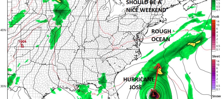
GFS FORECAST FOR SATURDAY MORNING 9/16/2017

Hurricane Jose will be somewhere east of Florida and southeast of the North Carolina coast on Saturday morning. The upper air pattern suggests that it could get somewhat complicated next week and by know you may have heard that there are all sorts of weird scenarios that could play out. There are also all sorts of out to sea scenarios that could play out as well. For now we are just going to watch and see how this all evolves so in the meantime what we can say that the impacts of a rough ocean will continue for the rest of this week and through the weekend with Jose close by. We will address Jose more specifically later today. Right now Hurricane Jose is no threat to land and remains a minimal hurricane at best.
..JOSE MOVING SOUTHEASTWARD OVER THE SOUTHWEST ATLANTIC BETWEEN THE
BAHAMAS AND BERMUDA…
SUMMARY OF 500 AM AST…0900 UTC…INFORMATION
———————————————-
LOCATION…26.1N 66.0W
ABOUT 505 MI…810 KM ENE OF THE SOUTHEASTERN BAHAMAS
ABOUT 435 MI…700 KM S OF BERMUDA
MAXIMUM SUSTAINED WINDS…75 MPH…120 KM/H
PRESENT MOVEMENT…SE OR 135 DEGREES AT 8 MPH…13 KM/H
MINIMUM CENTRAL PRESSURE…985 MB…29.09 INCHES
WATCHES AND WARNINGS
——————–
CHANGES WITH THIS ADVISORY:
None.
SUMMARY OF WATCHES AND WARNINGS IN EFFECT:
There are no coastal watches or warnings in effect.
DISCUSSION AND 48-HOUR OUTLOOK
——————————
At 500 AM AST (0900 UTC), the center of Hurricane Jose was located
near latitude 26.1 North, longitude 66.0 West. Jose is moving toward
the southeast near 8 mph (13 km/h), but it is expected to make a
slow clockwise loop during the next 36 to 48 hours, moving west-
northwestward by late Thursday.
Maximum sustained winds are near 75 mph (120 km/h) with higher
gusts. Little change in strength is forecast during the next
48 hours.
Hurricane-force winds extend outward up to 25 miles (35 km) from the
center and tropical-storm-force winds extend outward up to 140 miles
(220 km).
The estimated minimum central pressure is 985 mb (29.09 inches).
HAZARDS AFFECTING LAND
———————-
None
 GET JOE A CIGAR IF YOU LIKE

FiOS1 News Weather Forecast For Long Island
FiOS1 News Weather Forecast For New Jersey
FiOS1 News Weather Forecast For Hudson Valley


