Warm Front Approaches With Showers Tonight,
Warm More Humid Thunderstorms Severe Weather Risk Saturday
We are going to see nice weather day overall but there are changes looming. We can see them to the west on the satellite loop where clouds, showers & thunderstorms are showing up. Also some high clouds are moving across to the north in Upstate NY and New England. These clouds will gradually shift southward and begin to increase from west to east across Eastern Pennsylvania to Southern New England later today. All of this is ahead of warm front. Skies should be partly sunny or no worse than that though clouds will increase. High temperatures todayh will be mostly in the low to middle 70s except 60s along the coast with local sea breezes.
SATELLITE WITH LIGHTNING STRIKES
WEATHER RADAR
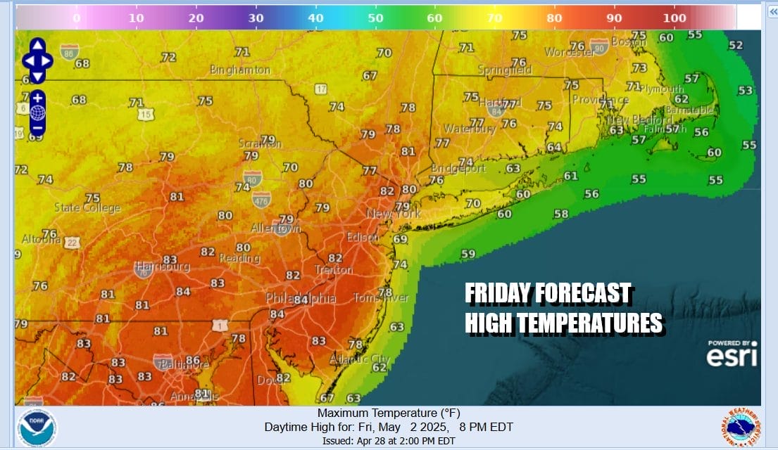
Tonight we see a warm front developing to the south and then it moves northeastward overnight. There could be a downpour or a thunderstorm as the front moves through. Temperatures overnight. will likely hold in the mid 50s to lower 60s. Friday will be a partly sunny very warm and more humid day as a south to southwest wind helps to send temperatures up into the low and middle 80s in many areas away from the coast.
Over the weekend our attention will first turn to another Midwest low pressure area that heads northeastward with a trailing cold front. The low is going to get hung up in the Ohio Valley as a strong upper trough digs southeastward into the Appalachians. The result will be areas of showers and thunderstorms over the weekend but the when and where will be hard to time depending on how the upper trough sets up and where the surface low winds up.
With a low to the west and a frontal boundary that initially sets up across Upstate NY and Central New England, it is possible that some of the thunderstorms that develop later Saturday into Saturday night could be severe. The Storm Prediction Center on its initial forecast for Saturday into Sunday morning is indicating a marginal risk for isolated severe thunderstorms but we think that this could get elevated to a slight risk at some point.
Sunday is a bit of a tough call with low pressure in the Central Appalachians and an onshore flow. This could set up for a gloom & doom type Sunday with showery rains around and perhaps a thunderstorm or two. However at this point it doesn’t appear that this will turn into an all day rain. Highs will be in the cooler 60s to near 70 especially if the onshore flow does indeed materialize. Next week we could see showery rains for the first part of next week as an upper trough and low pressure remain stuck in the Eastern US.
BE SURE TO DOWNLOAD THE FREE METEOROLOGIST JOE CIOFFI WEATHER APP &
ANGRY BEN’S FREE WEATHER APP “THE ANGRY WEATHERMAN!
MANY THANKS TO TROPICAL TIDBITS FOR THE USE OF MAPS
Please note that with regards to any severe weather, tropical storms, or hurricanes, should a storm be threatening, please consult your local National Weather Service office or your local government officials about what action you should be taking to protect life and property.