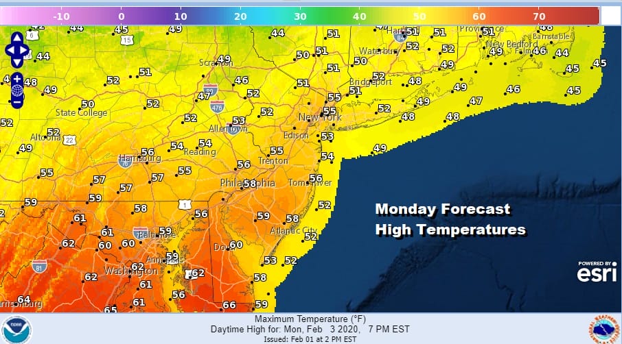
Warm Air Arrives With Snow/Rain Showers Monday Tuesday Warm Days
At least we got some of the clouds out of the way to allow for some sunshine to start the day however there are clouds coming in from the west ahead of a warm front This warm front marks the leading edge of warmer air that will be here for Monday. Tuesday, and at least the first part of Wednesday before colder air returns. This will not be anything record setting but it will send temperatures probably about 10 or so degrees above average for this time of year. Highs today will be in the low to mid 40s as clouds increase this afternoon.
SATELLITE

REGIONAL RADAR

The radar shows a band of snow showers in Western Pennsylvania moving eastward. These snow showers will start to come into the range of the local radars this afternoon. Where temperatures are at the higher end of the days range rain showers are possible while in some colder areas with elevation there may be enough to whiten the coldest surfaces.
LOCAL RADAR NEW YORK CITY

LOCAL RADAR PHILADELPHIA


Once the warm front goes by we get into a west northwest wind, high pressure to the south and that sets us up for some sunshine on Monday. Highs should reach the 50s and we could see 60s from Southern New Jersey to Southern Pennsylvania south into Maryland and Virginia. North of NYC we will see upper 40s and lower 50s.
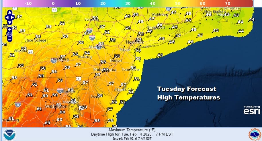
Tuesday brings another day of warmer than normal temperatures and an approaching cold front. With that the chance of scattered showers is forecast with highs in the 50s to near 60.
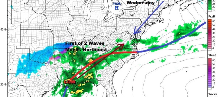
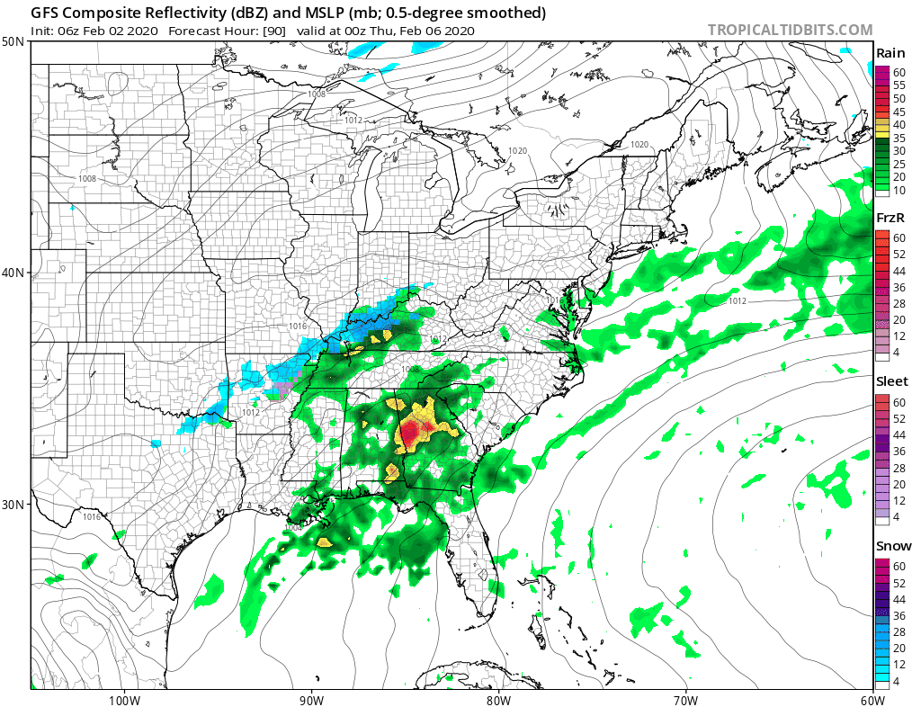
This cold front will move through on Wednesday with the likelihood of some early showers before winds shift to the north and northeast and colder air begins to arrive. To the south the front will stall out and 2 waves of low pressure will be moving northeastward. The first arrives late Wednesday night into Thursday morning and in theory at least it may actually be cold enough for snow or a wintry mix of precipitation at the start.
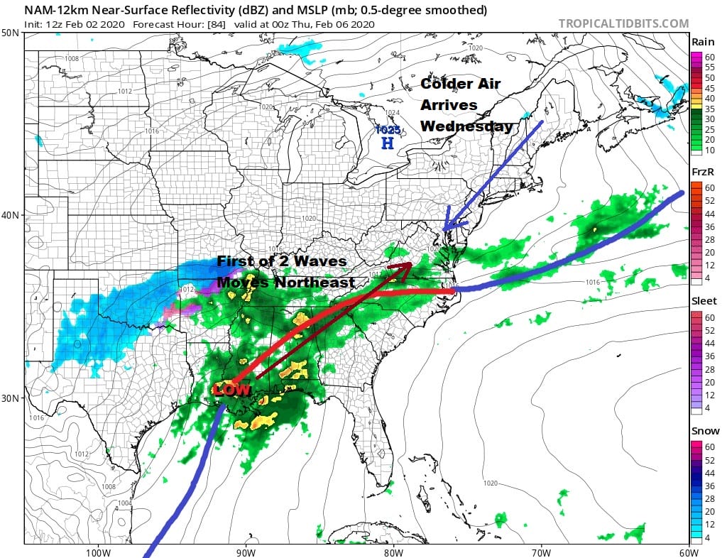
Wave number one arrives late Wednesday night into Thursday morning. It is conceivable that low levels will be cold enough to support snow sleet or freezing rain at least for a time from Eastern Pennsylvania to Southern New England on Thursday. We have noticed that today’s nam model run finishes with a colder look by Wednesday evening. At this point the frontal boundary as the map above shows has pushed down to North Carolina while the mid and low levels of the atmosphere are actually rather cold by Wednesday evening.

The thermal boundary here is very tight from NYC down to Southeast Virginia with a rather large temperature spread. The freezing line which would mark the rough position of the rain snow line runs from Atlantic City to Wilmington Delaware to just north of Baltimore/Washington DC. This would be for Wednesday night. The buckling of that frontal boundary will begin overnight Wednesday into Thursday and we will likely see an area of snow and sleet break out just north of the zero degree line.
Last night’s warmer GFS model run would suggest a quick shot of snow or sleet before a change to rain and then a second wave of low pressure that intensifies as it moves northward. This brings a soaking rain here Thursday night into Friday with snow well north in NY State and interior New England. This winter obviously has been one where snow has been utterly elusive and you have to ask yourself what if anything is different this time around. There is no blocking at all to force a colder solution. In fact quite the opposite is going on with a fast flow with everything moving from west to east and not slowing down. Changes in the Pacific are going to allow for some colder air to try to come into the East but the overall pattern is just terrible right now for any kind of start to finish snow event. We will have more on this situation later today. By the way the Groundhog has spoke and an early spring is forecast by rodent (stroke of genius) but he left us with no Super Bowl pick.
BE SURE TO DOWNLOAD THE FREE METEOROLOGIST JOE CIOFFI WEATHER APP &
ANGRY BEN’S FREE WEATHER APP “THE ANGRY WEATHERMAN!
MANY THANKS TO TROPICAL TIDBITS FOR THE USE OF MAPS
Please note that with regards to any severe weather, tropical storms, or hurricanes, should a storm be threatening, please consult your local National Weather Service office or your local government officials about what action you should be taking to protect life and property.


