Warm 50s Saturday Snow Chance Super Bowl Sunday
Cold Start Before Warm Up Next Week

Warm 50s Saturday Snow Chance Super Bowl Sunday
Cold Start Before Warm Up Next Week
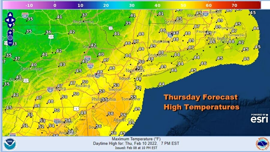
We have a cold front moving through today but it isn’t much of one. Some scattered showers showed up on the radar overnight and we had clouds overnight too and that kept temperatures in check. Now we will move ahead to day with decreasing clouds and some sun breaking through later today. Highs will reach the upper 40s to middle 50s across the area as the high temperature map shows. Whatever patchy fog that is around will dissipate as the day wears on.
SATELLITE

WEATHER RADAR

Our run of above normal temperatures will continue for the next 2 days taking us to Saturday. Skies will be clear tonight for most of the area from Eastern Pennsylvania to Southern New England. Lows will be in the 20s inland and lower 30s at the coast. Friday will be a nice day of sunshine as highs again reach the upper 40s to mid 50s.

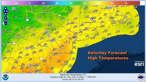
Saturday will be the last “warm” day of the current stretch as an arctic boundary approaches. This cold front will slide through during the afternoon but the colder air behind it will wait until nightfall to move in. Look for sunshine and then perhaps some clouds as the front nears. Highs will reach the low to mid 50s.
The front will stall to our south offshore and cold air from high pressure from the Northern Great Lakes will wedge into New England. That will send temperatures down into the 20s by Sunday morning. At the same time energy in the Western Great Lakes swings around and forces a wave to develop on the arctic boundary and head northeast. Models overnight have tightened up a bit as far as an outcome. This doesn’t appear to be a big deal from what we are seeing. The upper air across most of the models suggests any deepening of the arctic frontal wave would occur well offshore.
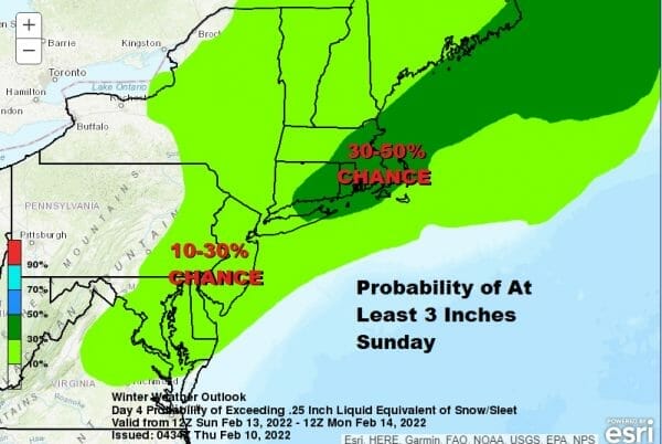
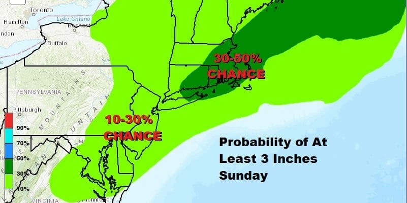
Some snow could develop during Saturday night and last into at least part of Sunday. Right now the Weather Prediction Center has much of the area from Northeast Virginia to Southern New England at a 10 to 30% chance for at least 3 inches and 30 to 50% from Eastern Long Island and Southeast Connecticut to Southeastern New England. A lot will depend on how far south the front gets and when and where the wave develops. Global models favor a track further south while the short range models say further north! That doesn’t make forecasting any easier. I think there is the potential for a few inches out of this. Temperatures Sunday will likely be in the 20s all day. Once the wave goes by it will be very cold Sunday night with Monday morning lows in the teens. Highs Monday will be just in the 20s.
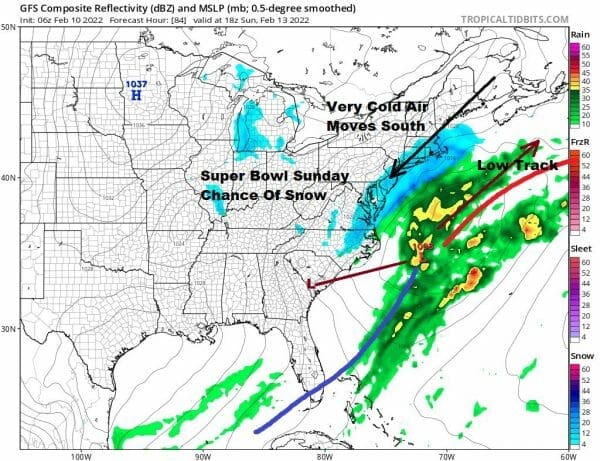
A couple of things that we will be looking for with this system include a faster developing wave and a track that is northwest of what is currently being forecast. There has been a tendency for these systems to come back west or northwestward as we draw closer and that is something that may not show up until tomorrow or Saturday so we will keep an eye on that. The snow we will get is actually being generated by the upper air feature moving through and less about the coastal low itself as its heavier precipitation will remain offshore.
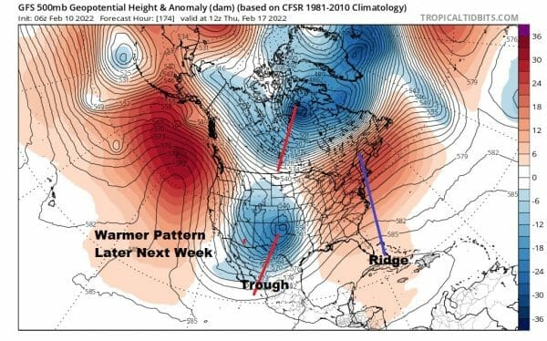
Longer term we will warm up next week as the trough in the east pulls out and we see one drop into the Western US. This will take temperatures higher and it will also take any snow risk away from our daily forecast routine. Cold air will be temporarily cut off from Canada. Rain and wind will come at the end of the week ahead of a cold front. This pattern doesn’t look like a switch but more like a relaxation as the longer range wants to bring the trough back into the Eastern US though how strong it will be is a question. We will let that play itself out and focus on the short term.
BE SURE TO DOWNLOAD THE FREE METEOROLOGIST JOE CIOFFI WEATHER APP &
ANGRY BEN’S FREE WEATHER APP “THE ANGRY WEATHERMAN!
MANY THANKS TO TROPICAL TIDBITS & F5 WEATHER FOR THE USE OF MAPS
Please note that with regards to any severe weather, tropical storms, or hurricanes, should a storm be threatening, please consult your local National Weather Service office or your local government officials about what action you should be taking to protect life and property.


