Very Warm Thunderstorm Risk Later Today
Onshore Flow Curse Returns Thursday
When you start the day with temperatures in the 60s on April 1st, you know it is going to be a very warm day. We are going to have cloud issues today along with some scattered showers this morning into this afternoon so this might impact temperatures. We still however expect temperatures to reach the middle to upper 70s away from the ocean from New York City south and upper 60s to lower 70s from New York City north.
An active cold front is approaching as evident on the satellite and radar loops. Showers and some thunderstorms will likely be in play later this afternoon and evening as the front struggles to move from north to south. This opens the door to the possibility of severe weather risk and the Storm Prediction Center is indicating a marginal risk for isolated severe thunderstorms mainly for Southern New Jersey, Southern Pennsylvania and points southward into Maryland Delaware and Virginia. General thunderstorm activity is flanked around the risk zone and that reaches north into the Hudson Valley and Southern New England.
SATELLITE WITH LIGHTNING STRIKES
WEATHER RADAR
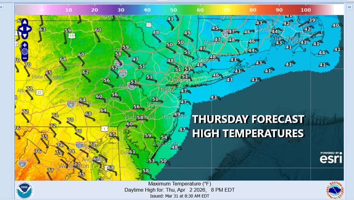
There will be some shower activity overnight lasting until about daybreak in some areas but there will also be a wind shift to the northeast and east and that brings the “Curse of the Onshore Flow” into play for Thursday. It is going to be a raw day with overcast skies and the risk for some patchy light rain or drizzle. In other words, a miserable spring day with highs just in the 40s except lower 50 from South Jersey southward.
Low pressure will be coming out of the Plains and into the Great Lakes Friday which is going to force the high pressure area offshore to exit. Winds Friday will turn south and southwest and this will break the onshore flow curse (except for coastal areas) and we will see some sun breaking through the clouds along with higher temperatures especially Saturday which will be very warm. Friday highs will be back in the 70s away from the ocean. Saturday highs inland will be in the upper 70s to lower 80s.
The next cold front, and it is a strong one will approach Eastern Sunday but we expect the dayside to be dry and showers and thunderstorms won’t threaten until late in the afternoon and evening. Once that front passes, a colder weather pattern starts off the first half of next week with three days of below average temperatures likely but it will also be dry through the middle part of next week.
BE SURE TO DOWNLOAD THE FREE METEOROLOGIST JOE CIOFFI WEATHER APP &
ANGRY BEN’S FREE WEATHER APP “THE ANGRY WEATHERMAN!
MANY THANKS TO TROPICAL TIDBITS FOR THE USE OF MAPS
Please note that with regards to any severe weather, tropical storms, or hurricanes, should a storm be threatening, please consult your local National Weather Service office or your local government officials about what action you should be taking to protect life and property.