Very Warm Saturday Cooler Cloudy Sunday Monday Passing Showers
Very Warm Saturday Cooler Cloudy Sunday Monday
Passing Showers
It is certainly a warm Saturday and a very warm start to the Memorial Day weekend. We are seeing a fari amount of sunshine. To the north on the satellite loop you can see clouds that are associated with the next cold front. That front will be approaching us this evening. It could trigger off a couple of widely scattered showers or a thunderstorm but right now the bet is that most areas will get away with not seeing much of anything this evening. Best chances for a shower or thundertorm look to be in South Jersey & Southeast Pennsylvania. Temperatures are moving through the 80s and some highs near 90 degrees are possible this afternoon away from the ocean.
EASTERN SATELLITE
REGIONAL RADAR
Regional & local radars are quiet for the time being and I don’t expect much to pop up until after 3 or 4 pm. I don’t expect any severe weather issues either so stick with outdoor plans for the remainder of the day and keep an eye on the sky this evening in case a shower or thunderstorm pops up in your neighborhood.
LOCAL RADAR NEW YORK CITY
LOCAL RADAR PHILADELPHIA

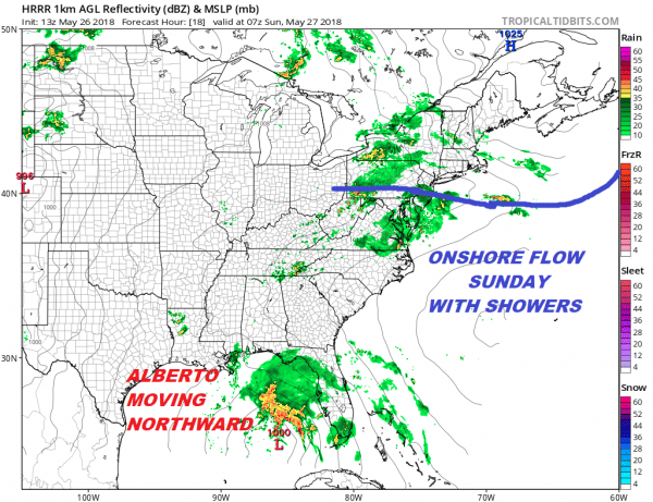
The front will stall to our south and overnight some downpous will develop along and just north of the frontal boundary. We may see these showers pass through Sunday morning arriving before daybreak and done I think in most areas by mid morning.
The rest of Sunday will be in clouds and passing showers with temperatures in the 60s to near 70 but some areas in South Jersey & Southeastern Pennsylvania could be in the warmer 70s to low 80s depending on exactly where the frontal boundary sets up. Monday Memorial Day look for lots of clouds with the chance for a passing shower but I think for most Monday is rain free. Highs on average Monday will be in the upper 60s to middle 70s.
LATEST VIDEO ON SUBTROPICAL STORM ALBERTO
...ALBERTO FORECAST TO STRENGTHEN WHILE MOVING NORTHWARD OVER THE
GULF OF MEXICO...
...HEAVY RAINFALL EXPECTED TO AFFECT WESTERN CUBA...FLORIDA...AND
THE NORTHEASTERN GULF COAST THROUGH THE WEEKEND...


SUMMARY OF 1100 AM EDT...1500 UTC...INFORMATION
-----------------------------------------------
LOCATION...21.6N 84.9W
ABOUT 20 MI...35 KM S OF THE WESTERN TIP OF CUBA
ABOUT 250 MI...400 KM SSW OF THE DRY TORTUGAS
MAXIMUM SUSTAINED WINDS...40 MPH...65 KM/H
PRESENT MOVEMENT...N OR 10 DEGREES AT 10 MPH...17 KM/H
MINIMUM CENTRAL PRESSURE...1005 MB...29.68 INCHES


WATCHES AND WARNINGS
--------------------
CHANGES WITH THIS ADVISORY:

The government of Cuba has issued a Tropical Storm Warning for the
Cuban province of Pinar del Rio.

A Tropical Storm Warning has been issued for the Dry Tortugas in the
Florida Keys.

A Tropical Storm Watch has been issued for the west coast of the
Florida peninsula from Boca Grande to Anclote River.  The Tropical
Storm Watch along the coast of the Florida panhandle has been
extended eastward to the Aucilla River.

The Storm Surge Watch has been extended eastward to Crystal River,
Florida.

SUMMARY OF WATCHES AND WARNINGS IN EFFECT:

A Storm Surge Watch is in effect for...
* Crystal River to the Mouth of the Mississippi River

A Tropical Storm Warning is in effect for...
* Cuban province of Pinar del Rio
* Dry Tortugas

A Tropical Storm Watch is in effect for...
* Boca Grande to Anclote River
* Aucilla River to Grand Isle
* Lake Pontchartrain and Lake Maurepas

A Storm Surge Watch means there is a possibility of life-
threatening inundation, from rising water moving inland from the
coastline, in the indicated locations during the next 48 hours.
For a depiction of areas at risk, please see the National Weather
Service Storm Surge Watch/Warning Graphic, available at
hurricanes.gov.

A Tropical Storm Warning means that tropical storm conditions are
expected somewhere within the warning area, in this case within
the next 24 hours.

A Tropical Storm Watch means that tropical storm conditions are
possible in the United States portion of that watch area within
48 hours.

For storm information specific to your area in the United
States, including possible inland watches and warnings, please
monitor products issued by your local National Weather Service
forecast office. For storm information specific to your area outside
the United States, please monitor products issued by your national
meteorological service.


DISCUSSION AND OUTLOOK
----------------------
At 1100 AM EDT (1500 UTC), the center of Subtropical Storm Alberto
was located near latitude 21.6 North, longitude 84.9 West. The storm
is moving toward the north near 10 mph (17 km/h).  A northward or
north-northeastward motion is expected today, followed by a turn to
the northwest on Sunday.  On the forecast track, the center of
Alberto is expected to move near the western tip of Cuba this
afternoon, track across the eastern Gulf of Mexico tonight through
Monday, and approach the northern Gulf Coast in the watch area
Monday night.

Maximum sustained winds are near 40 mph (65 km/h) with higher gusts.
Gradual strengthening is forecast until the system reaches the
northern Gulf Coast by Monday night.

Winds of 40 mph extend outward up to 140 miles (220 km) mainly to
the east of the center.

The estimated minimum central pressure is 1005 mb (29.68 inches).
 GET JOE A CIGAR IF YOU LIKE
FiOS1 News Weather Forecast For Long Island
FiOS1 News Weather Forecast For New Jersey
FiOS1 News Weather Forecast For Hudson Valley
NATIONAL WEATHER SERVICE SNOW FORECASTS
LATEST JOESTRADAMUS ON THE LONG RANGE


