Very Cold Windy Night However Very Warm Springlike Temperatures This Weekend
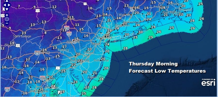
It was a day of clouds, various snow showers, a few heavier snow squalls, gusty winds and temperatures in the 30s. Now we head into a very cold windy night with skies clearing out during the overnight. This is going to be one of those quick shots of cold air that is coming in now and will start to go out 24 hours from now. Most lows will be in the teens to near 20 degrees by morning and you can subtract 10 degrees or so off the air temperature to give you the wind chill.
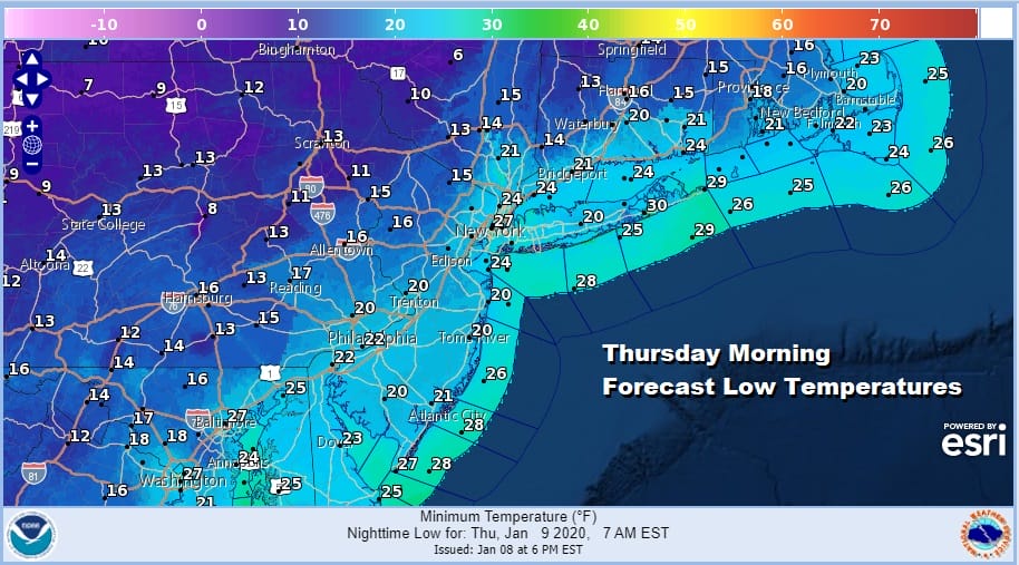
Yesterday’s coastal storm is well offshore to the northeast and passing southeast of Nova Scotia. The upper trough over the Great Lakes is now moving into Eastern Canada and so for a short time we have a Canadian connection to some colder air that is driving southeastward into the Northeast & Northern Mid Atlantic states. It will not last as the cold air will start to move out at this time tomorrow night.
SATELLITE

REGIONAL RADAR

Regional and local radars are showing what is left of snow shower and snow squall activity today which was particularly active for much of the day. The upper trough responsible for this is passing through so you can look for these snow showers to diminish and disappear from view overnight.
LOCAL RADAR NEW YORK CITY

LOCAL RADAR PHILADELPHIA


Thursday looks like a sunny day and the gusty winds should begin to ease during the afternoon. Highs Thursday wlll be in the cold 30s but temperatures tomorrow night will likely hold in the mid 20s to lower 30s as winds go to the west and then to the southwest.
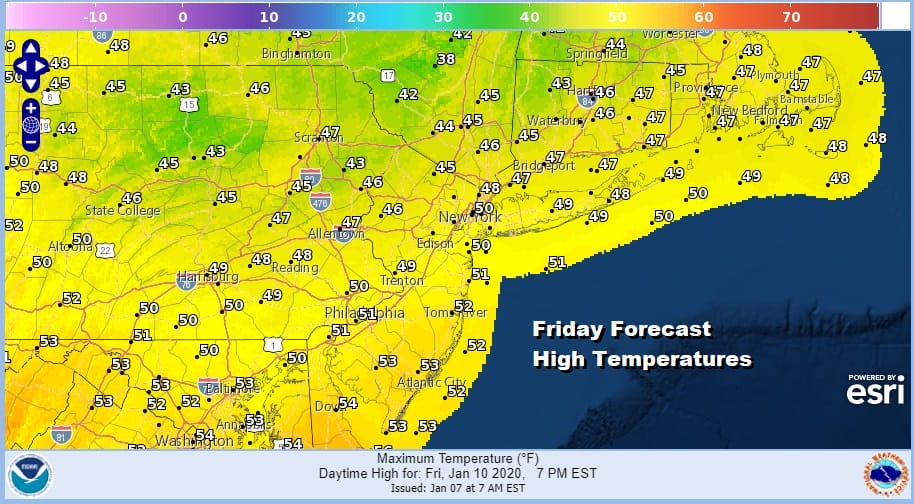
There is no change to the outlook for Friday and Saturday as warm air surges up the East Coast. Friday we should have some sunshine taking highs into the 50s. Saturday is going to be very warm with some sun and clouds though clouds might dominate later in the day. Highs Saturday will reach into the 60s in many areas and record highs are possible.
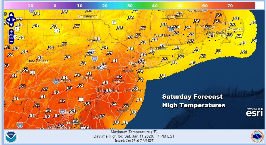
Low pressure will be headed up the Ohio Valley and up the west side of the Appalachians Saturday night and Sunday and this brings a chance for showers and possibly even a thunderstorm as the cold front swings eastward. It isn’t something you see to often this time of year but it does happen from time to time.
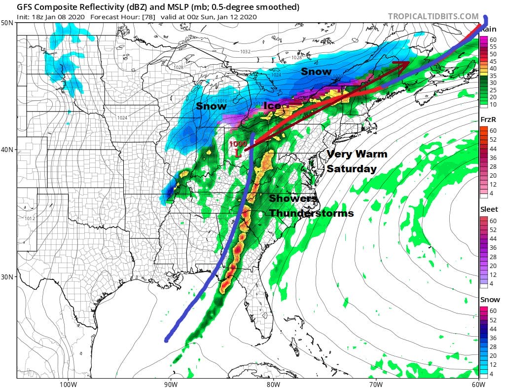
If everything times perfectly we can get the front through here Sunday morning and confine any rain to the Saturday night Sunday morning time frame, and then weather conditions could improve after that with leftover clouds and highs still in the 50s to near 60. While it may be a little cooler early next week temperatures will remain above average as all the cold air remains locked up in the Western US and well to the north in the Arctic region.
BE SURE TO DOWNLOAD THE FREE METEOROLOGIST JOE CIOFFI WEATHER APP &
ANGRY BEN’S FREE WEATHER APP “THE ANGRY WEATHERMAN!
MANY THANKS TO TROPICAL TIDBITS FOR THE USE OF MAPS
Please note that with regards to any severe weather, tropical storms, or hurricanes, should a storm be threatening, please consult your local National Weather Service office or your local government officials about what action you should be taking to protect life and property.


