Tropical Storm Watch Carolinas Disturbance Stationary For Now
Tropical Storm Watch Carolinas Disturbance Stationary For Now
There has not been much change in the disturbance off the Southeast Coast of the US and it has not reached tropical storm strenght as of yet. Due to the outflow from Harvey there is some northerly shear going on which is why you do not see much happening on the west side of the surface low. In the last few hours there appears to be some convection firing up near the center and if this continues we could see Tropical Storm Irma later today.

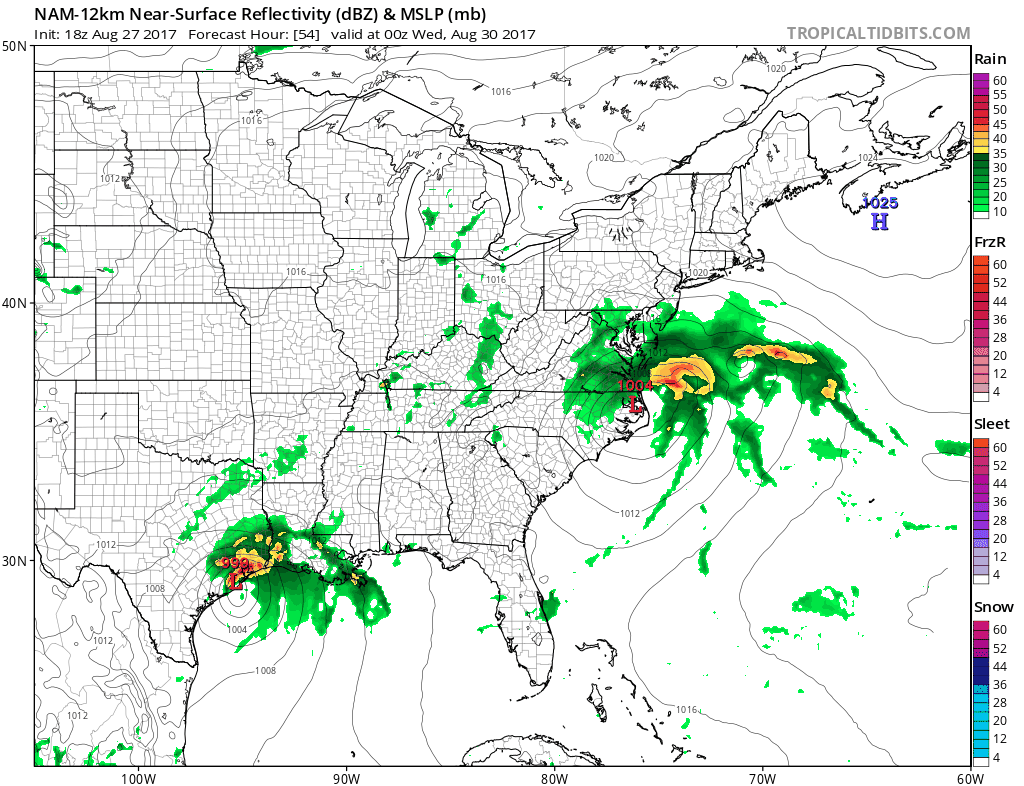
The center of circulation of the low is seen on the Jacksonville radar. Thunderstorms are all offshore at the moment and there is not much going on along the coast other than some clouds.

..DISTURBANCE CONTINUES NEARLY STATIONARY AND POORLY ORGANIZED FOR
NOW…
SUMMARY OF 800 AM EDT…1200 UTC…INFORMATION
———————————————-
LOCATION…31.0N 80.7W
ABOUT 135 MI…215 KM SSW OF CHARLESTON SOUTH CAROLINA
ABOUT 280 MI…450 KM SW OF WILMINGTON NORTH CAROLINA
MAXIMUM SUSTAINED WINDS…35 MPH…55 KM/H
PRESENT MOVEMENT…STATIONARY
MINIMUM CENTRAL PRESSURE…1007 MB…29.74 INCHES
WATCHES AND WARNINGS
——————–
CHANGES WITH THIS ADVISORY:
None.
SUMMARY OF WATCHES AND WARNINGS IN EFFECT:
A Tropical Storm Watch is in effect for…
* South Santee River to Duck
* Albemarle Sound
* Pamlico Sound
A Tropical Storm Watch means that tropical storm conditions are
possible within the watch area, in this case within the next 24 to
36 hours.
For storm information specific to your area, including possible
inland watches and warnings, please monitor products issued by your
local National Weather Service forecast office.
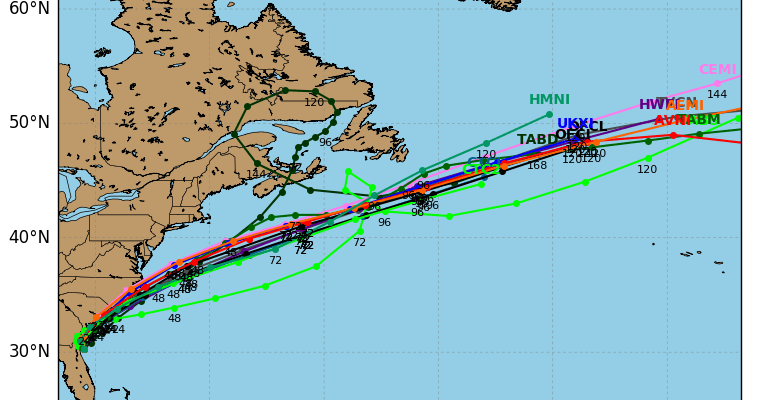
DISCUSSION AND 48-HOUR OUTLOOK
——————————
At 800 AM EDT (1200 UTC), the poorly defined circulation associated
with the disturbance was estimated near latitude 31.0 North,
longitude 80.7 West. The system has been moving little, and a
slow and erratic motion is forecast through this afternoon, followed
by a faster northeastward motion tonight and Tuesday. On the
forecast track, the system will move near the Georgia and South
Carolina coasts later today and move along the North Carolina
coast on Tuesday.
Maximum sustained winds remain near 35 mph (55 km/h) with higher
gusts. Some strengthening is possible during the next 48 hours, and
the system is expected to become a tropical storm by Tuesday morning
and then become post-tropical by Tuesday night.
Although satellite and radar data indicate that the associated
showers and thunderstorms show some signs of organization, the
center of circulation is not yet well defined. Only a slight
increase in the definition of the circulation would lead to the
formation of a tropical cyclone.
* Formation chance through 48 hours…high…90 percent
* Formation chance through 5 days…high…90 percent
The estimated minimum central pressure is 1007 mb (29.74 inches).
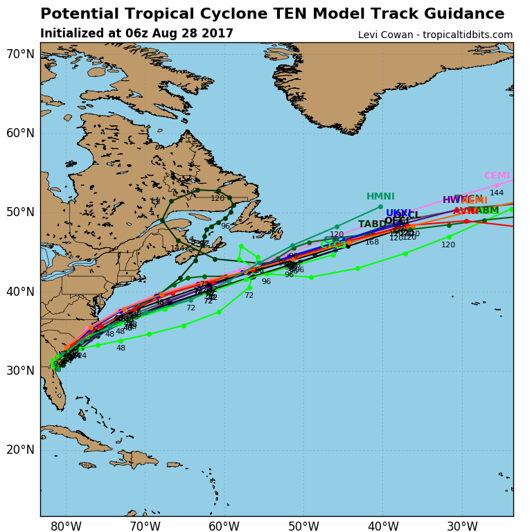
There is no change in my outlook for this system. Whether it does or doesn’t develop, weather models are all consistent with an offshore track. As far as out weather is concerned I still think the northern fringe of the rain gets to about Southern New Jersey for a short time and out over the coastal waters. There will be gales offshore along with rough ocean conditions for several days. But as far as tropical storm conditions they will be confined to the coastal Carolinas.
MANY THANKS TO TROPICAL TIDBITS FOR THE WONDERFUL USE OF THE MAPS
Weather App

Don’t be without Meteorologist Joe Cioffi’s weather app. It is really a meteorologist app because you get my forecasts and my analysis and not some automated computer generated forecast based on the GFS model. This is why your app forecast changes every 6 hours. It is model driven with no human input at all. It gives you an icon, a temperature and no insight whatsoever.
It is a complete weather app to suit your forecast needs. All the weather information you need is right on your phone. Android or I-phone, use it to keep track of all the latest weather information and forecasts. This weather app is also free of advertising so you don’t have to worry about security issues with your device. An accurate forecast and no worries that your device is being compromised.
Use it in conjunction with my website and my facebook and twitter and you have complete weather coverage of all the latest weather and the long range outlook. The website has been redone and upgraded. Its easy to use and everything is archived so you can see how well Joe does or doesn’t do when it comes to forecasts and outlooks.
Just click on the google play button or the apple store button on the sidebar for my app which is on My Weather Concierge. Download the app for free. Subscribe to my forecasts on an ad free environment for just 99 cents a month.
Get my forecasts in the palm of your hand for less than the cost of a cup of Joe!