Tropical Storm Warnings Tornado Watch Strong Winds Long Island This Afternoon

Tropical Storm Warnings continue into this evening and now front and center for Long Island are the strong winds that will be overspreading the Island this afternoon and lasting into this evening before subsiding. Winds will gust to 60 or even 70 mph along the immediate coast. Rain is not going to be a big issue here as rainfall amounts should be mostly around an inch or even less as you go east. The one caveat there will be the thunderstorms on the east side that may be severe and the Storm Prediction Center has us not only under a Tornado Watch but they have the risk for tornadoes at 10% which is as high as I have ever seen it here.
SATELLITE

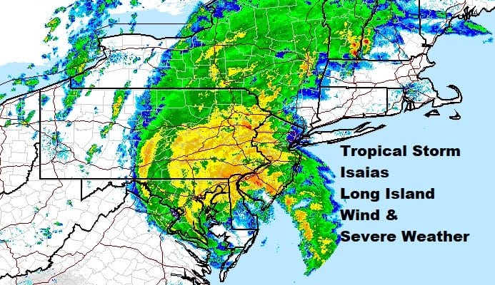
REGIONAL RADAR

Both the satellite and the regional radar show the well defined satellite and radar signatures of Isaias as it continues to move north northeastward. The heavy rains are falling along and west of the storm track as advertised for the last few days with less rain and more wind to the east of the track. Watch that arm of thunderstorms on the radar to the south because that is out of the core of the storm and we have already seen numerous tornadoes in Delaware and on the Delmarva Peninusla. That area will be moving in shortly.
LOCAL RADAR NEW YORK CITY

LOCAL RADAR PHILADELPHIA 

As far as the winds are concerned they will start picking up after noon time first in Western Long Island and then to the east around 1 or 2pm


The strongest winds will occur between 2pm and 6pm with peak winds probably between 3pm and 5pm. Once the storm passes to the northwest of us we should see winds start to drop off rather quickly later this evening.

Isaias will race up into New England tonight and drier air will come in later tonight. This should set us up for a nice Wednesday of some sunshine and slightly lower humidity with highs in the 80s.
MANY THANKS TO TROPICAL TIDBITS FOR THE USE OF MAPS
Please note that with regards to any tropical storms or hurricanes, should a storm be threatening, please consult your local National Weather Service office or your local government officials about what action you should be taking to protect life and property.