Tropical Storm Warnings Southern Windward Islands

Tropical Storm Warnings Southern Windward Islands
As part of a new policy the National Hurricane Center will be issuing advisories on tropical disturbances that threaten to imminently become tropical depressions or tropical storms when conditions warrent.
“The National Hurricane Center now has the option to issue advisories
on disturbances that are not yet tropical cyclones, but which pose
the threat of bringing tropical storm or hurricane conditions to
land areas within 48 hours. Under previous policy this was not
possible. These systems are known as Potential Tropical Cyclones in
advisory products and are numbered from the same list as
depressions.”

The latest satellite loop of the the tropical disturbance shows that while small, the convection is increasing around a developing circulation center. In all likelihood this will be upgraded to a tropical depression or a tropical storm overnight or on Monday.
BULLETIN
Potential Tropical Cyclone Two Advisory Number 2
NWS National Hurricane Center Miami FL AL022017
1100 PM AST Sun Jun 18 2017
…TROPICAL STORM CONDITIONS EXPECTED TO REACH THE SOUTHERN WINDWARD
ISLANDS BY MONDAY NIGHT…
SUMMARY OF 1100 PM AST…0300 UTC…INFORMATION
———————————————–
LOCATION…7.9N 52.4W
ABOUT 630 MI…1015 KM ESE OF TRINIDAD
ABOUT 695 MI…1120 KM ESE OF GRENADA
MAXIMUM SUSTAINED WINDS…40 MPH…65 KM/H
PRESENT MOVEMENT…W OR 280 DEGREES AT 23 MPH…37 KM/H
MINIMUM CENTRAL PRESSURE…1005 MB…29.68 INCHES
WATCHES AND WARNINGS
——————–
CHANGES WITH THIS ADVISORY:
None.
SUMMARY OF WATCHES AND WARNINGS IN EFFECT:
A Tropical Storm Warning is in effect for…
* Barbados
* St. Vincent and the Grenadines
* Trinidad
* Tobago
* Grenada
A Tropical Storm Warning means that tropical storm conditions are
expected somewhere within the warning area within 36 hours.
For storm information specific to your area, please monitor
products issued by your national meteorological service.
DISCUSSION AND 48-HOUR OUTLOOK
——————————
At 1100 PM AST (0300 UTC), the disturbance was centered near
latitude 7.9 North, longitude 52.4 West. A fast motion toward the
west-northwest is expected for the next 48 hours. On the forecast
track, the disturbance is expected to move through the Windward
Islands Monday night and Tuesday.
Maximum sustained winds have increased to near 40 mph (65 km/h) with
higher gusts. Some additional strengthening is expected during the
next 48 hours, and the disturbance is forecast to be a tropical
storm when it moves through the Windward Islands Monday night and
Tuesday.
Thunderstorm activity associated with the disturbance continues to
become better organized, and additional development is likely during
the next day or two.
* Formation chance through 48 hours…high…90 percent
* Formation chance through 5 days…high…90 percent
Tropical-storm-force winds extend outward up to 60 miles (95 km),
mainly northwest through northeast of the center.
The estimated minimum central pressure is 1005 mb (29.68 inches).
This system is probably one of the earliest tropical systems detected in the Tropical Atlantic. Normally you don’t see systems come out of the deep tropics in mid June. Weather models continue to move this on a west to west northwest course putting it in the Southeastern Caribbean in about 2 days.

You can see the system on the wider satellite loop and its perspective when compared to the broad low pressure system in the Northwest Caribbean. Satellite loops this evening show convection in that system increasing on the western side of the low center which is sitting just offshore the Yucatan Peninsula


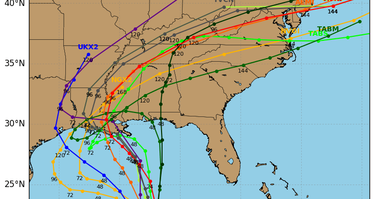
Weather models continue to show various tracks with this system once it gets into the Gulf of Mexico. The European and NAM models take it more to the west toward the South Texas coast over the next several days while the GFS and Canadian want to move it northward toward the Louisiana coast by midweek.
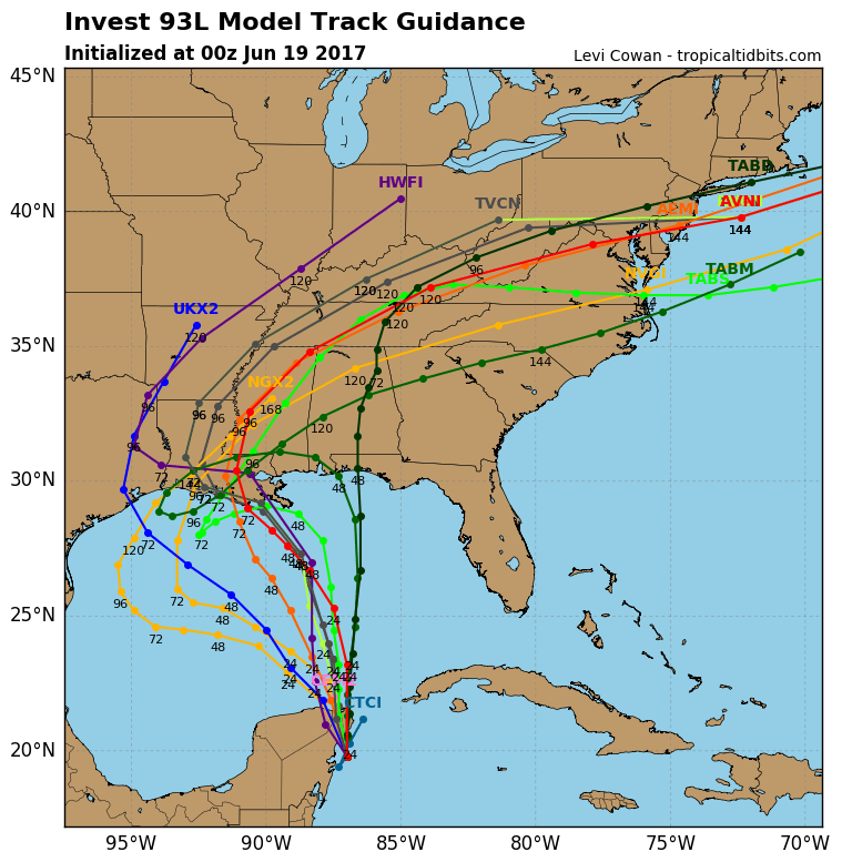
Some models including today’s late afternoon GFS model run want to bring that moisture up here by next weekend but it is way too early to speculate on that outcome. The European and NAM model with a more westerly course would mean this is not an issue for us in any fashion. As for the system approaching the Windwards, once it moves into the Southeast Caribbean it would be facing a rather hostile upper air environment.
JOESTRADAMUS HURRICANE SEASON GUEST FORECAST
FiOS1 News Weather Forecast For Long Island
FiOS1 News Weather Forecast For New Jersey
FiOS1 News Weather Forecast For Hudson Valley
NATIONAL WEATHER SERVICE SNOW FORECASTS
LATEST JOESTRADAMUS ON THE LONG RANGE
Weather App

Don’t be without Meteorologist Joe Cioffi’s weather app. It is really a meteorologist app because you get my forecasts and my analysis and not some automated computer generated forecast based on the GFS model. This is why your app forecast changes every 6 hours. It is model driven with no human input at all. It gives you an icon, a temperature and no insight whatsoever.
It is a complete weather app to suit your forecast needs. All the weather information you need is right on your phone. Android or I-phone, use it to keep track of all the latest weather information and forecasts. This weather app is also free of advertising so you don’t have to worry about security issues with your device. An accurate forecast and no worries that your device is being compromised.
Use it in conjunction with my website and my facebook and twitter and you have complete weather coverage of all the latest weather and the long range outlook. The website has been redone and upgraded. Its easy to use and everything is archived so you can see how well Joe does or doesn’t do when it comes to forecasts and outlooks.
Just click on the google play button or the apple store button on the sidebar for my app which is on My Weather Concierge. Download the app for free. Subscribe to my forecasts on an ad free environment for just 99 cents a month.
Get my forecasts in the palm of your hand for less than the cost of a cup of Joe!
![]()
![]()

MENTION JOE CIOFFI AND GET A 5% DISCOUNT