
Tropical Storm Warnings Flash Flood Watch Tuesday Isaias Heads Up The Coast
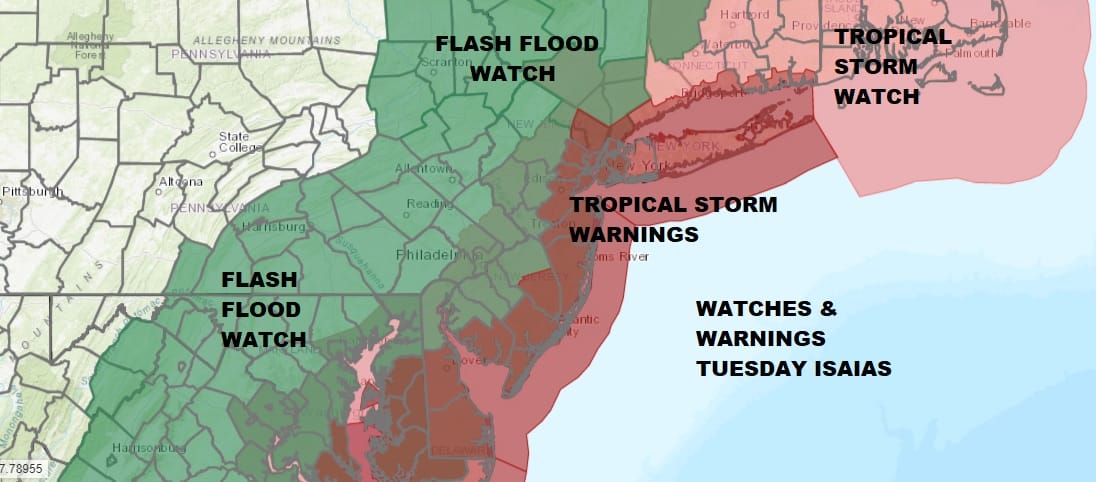
Tropical Storm Warnings are up for Tuesday from Eastern Connecticut and Eastern Long Island southward through the Carolinas. Flash Flood Watches are posted from Northwest Connecticut to the Hudson Valley to NYC west and south into Pennsylvania, New Jersey, Delaware Maryland and Virginia. At least we can see there are no weather issues today other than the fact that it will be very warm to hot and very humid and the odd shower or thunderstorm that could develop late this afternoon and evening. Highs in the 80s to near 90. It will be cooler along south facing shorelines thanks to a south wind off the ocean.
SATELLITE

5AM LOCATION…29.7N 79.9W
ABOUT 115 MI…185 KM ESE OF JACKSONVILLE FLORIDA
ABOUT 280 MI…455 KM SSW OF MYRTLE BEACH SOUTH CAROLINA
MAXIMUM SUSTAINED WINDS…70 MPH…110 KM/H
PRESENT MOVEMENT…N OR 355 DEGREES AT 9 MPH…15 KM/H
MINIMUM CENTRAL PRESSURE…994 MB…29.36 INCHES
REGIONAL RADAR

The satellite pictures and loops this morning show Isaias off the north coast of Eastern Florida and it is a strong tropical storm borderline hurricane. It keeps trying to strengthen however it is also fighting 25 knots of southwest winds aloft that give the system a bit of a tilt. There isn’t much going on along the coast. That will change it it approaches the Carolinas. Below are the radars from Morehead City North Carolina and Wilmington North Carolina so you can monitor the progress of Isaias. Rain is beginning to move onshore well north and northeast of the storm center.
LOCAL RADAR MOREHEAD CITY NC

LOCAL RADAR WILMINGTON NC


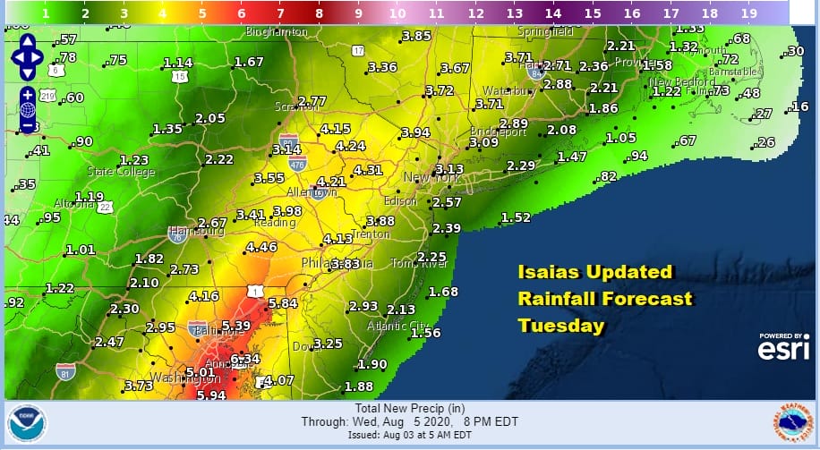
Other than some patchy showery rains that will develop overnight in areas mainly to the west of the coast we will likely just be quiet overnight with most lows in the low to mid 70s. Rain will gradually overspread the area from south to north on Tuesday. Remember the heaviest rain will be west and northwest of the track and the strongest wind gusts with less rain to the east. Rainfall totals of 4 inches or more are possible especially in and around any thunderstorms.
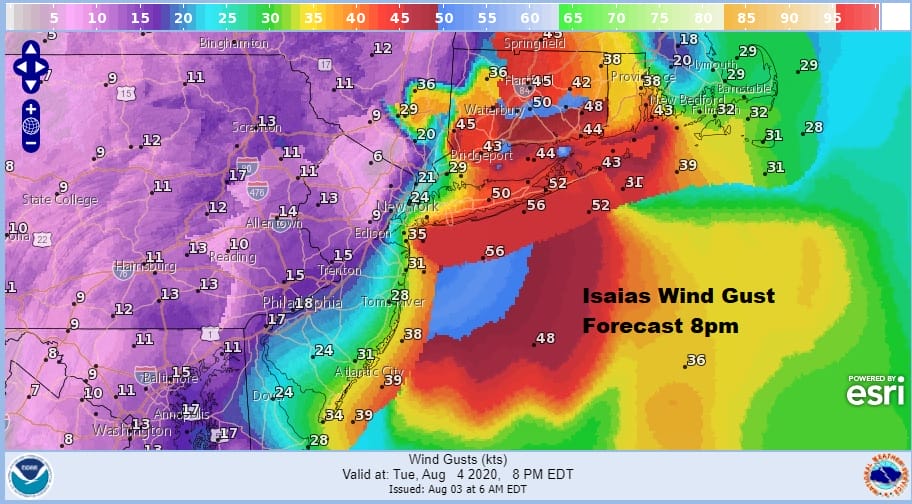
As far as the wind is concerned we are going to show you time frames so you can follow the area of maximum wind gusts. Remember this is going to last about 6 to at most 8 hours from start to finish.
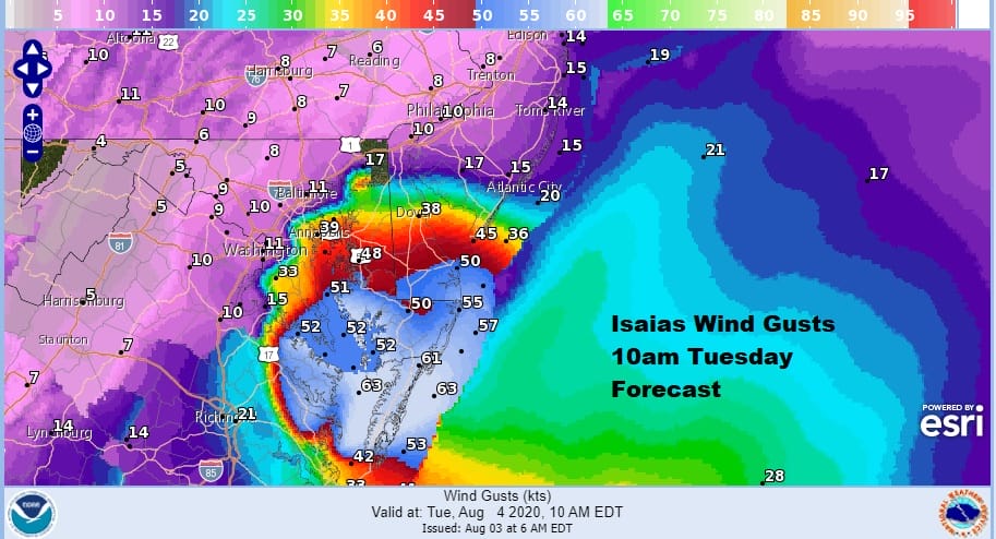
Starting at 10am gales will be moving into Southern New Jersey and will be well underway in Eastern Maryland and Delaware. By 2pm the area shifts northward but so does the back edge of the gales.

The slightly faster forward motion is being baked into the forecast today so it looks like the strongest winds arrive a bit soon by a few hours and those strong winds will be well underway around the NYC metro area at 5pm.
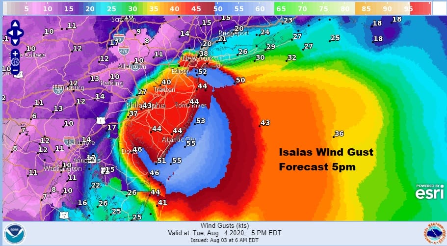
By 8pm winds will begin to subside to the west of NYC and southwest with some leftover gusts along the New Jersey shore. South facing shorelines of Southern New England and Long Islandw will still be dealing with gusts over 50 mph and that will coincide with the high tide Tuesday evening. This could mean at the very least some moderate coastal flooding at high tide for these areas.
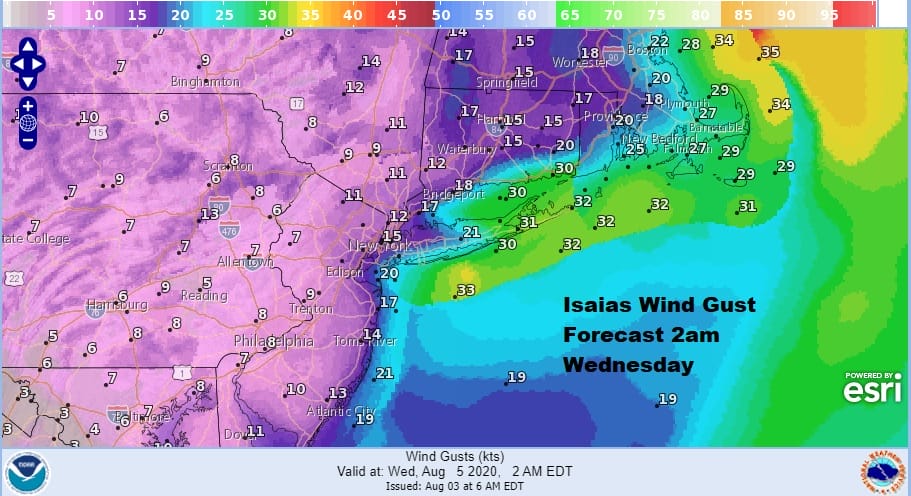
Winds will continue to ease as we move past midnight and into the early morning hours. By this time Isias will be well up into Northern New England.
As far as the weather models are concerned, all the tracks are pretty much the same. The only difference is the timing with the GFS still about 6 hours faster than the others and 6 hours faster than what we have indicated above. The National Hurricane Center’s forecast is leaning toward the slower models and we go along with that idea.

Once this is gone weather conditions will improve on Wednesday with some sunshine returning and highs in the 80s. Humidity levels north of NYC will drop though they will remain high to the south and southwest. Showers could be back on Thursday.
BE SURE TO DOWNLOAD THE FREE METEOROLOGIST JOE CIOFFI WEATHER APP &
ANGRY BEN’S FREE WEATHER APP “THE ANGRY WEATHERMAN!
MANY THANKS TO TROPICAL TIDBITS FOR THE USE OF MAPS
Please note that with regards to any severe weather, tropical storms, or hurricanes, should a storm be threatening, please consult your local National Weather Service office or your local government officials about what action you should be taking to protect life and property.


