Tropical Storm Outlook Week Ahead

Tropical Storm Outlook Week Ahead
No Development Forecast
Models Show Area of Interest Next Weekend
Gulf Of Mexico Satellite View

Western Atlantic Satellite View

Tropical Atlantic Satellite View

Looking across the tropics at the moment the satellite loops of all regions pretty much tell the same story. June is usually a month where developing is infrequent but not impossible. Of course we are already through the “C” storm as we saw Colin last week and Bonnie in Late May. It would seem that since we have seen early activity the odds of another tropical storm would be higher than in most years. For now however the tropics remain quiet.
Tropical Storm Outlook Week Ahead
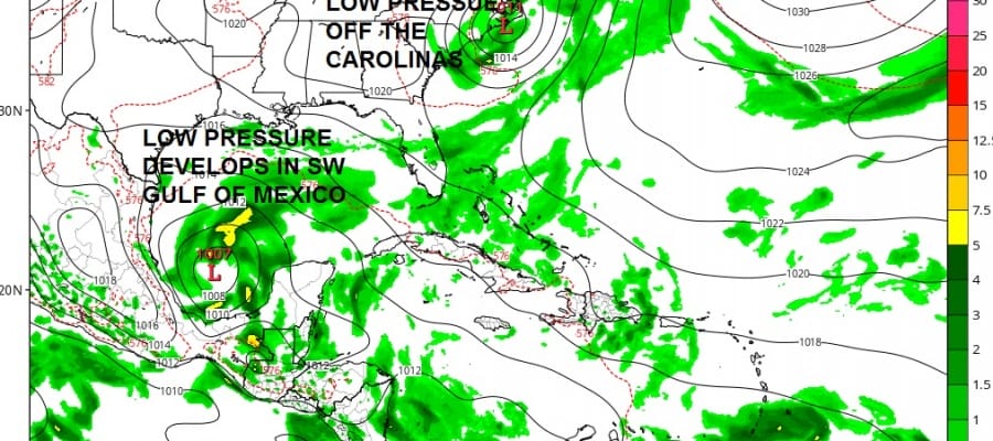
GFS Next Monday
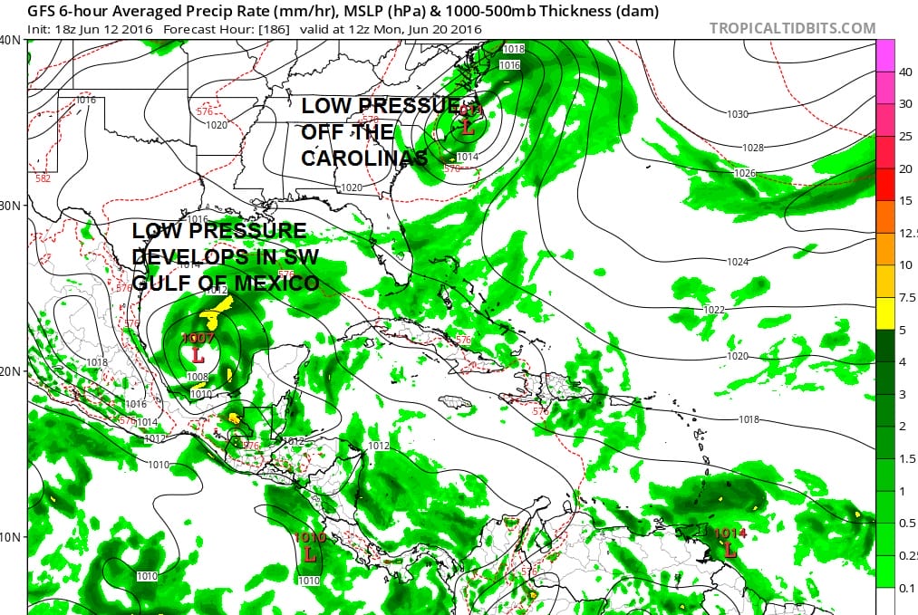
Two areas of interest appear on weather models next weekend. One is along and off the Carolinas and the other is in the Southwest Gulf of Mexico. With regards to the low off the Carolinas it begins as a non tropical low that moves off the southeast coast and sits offshore for a few days. The issue here is time. When non tropical lows move offshore they need to sit off the east coast for at least several days to transition to a tropical system. This even assumes that conditions would be favorable for development aloft. In the Southwest Gulf we have a system that probably has a better chance of development again depending on the upper winds.
Tropical Storm Outlook Week Ahead
Upper Air Shearing Profile Next Monday

The gulf low (assuming the models are correct on this) sits in a low shear environment though the outflow here is far from ideal. The Carolina low seems to be in a low shear in environment to the east but higher shear to the west which creates issues as does proximity to land and time over the warm water. These are two systems to watch though for now we are purely in speculative range. Of the two I think the low in the Southwest Gulf probably has the better shot and the Carolina low would likely remain non tropical in nature. At least that is the picture at the moment.
JOESTRADAMUS HURRICANE SEASON GUEST FORECAST
FiOS1 News Weather Forecast For Long Island
FiOS1 News Weather Forecast For New Jersey
FiOS1 News Weather Forecast For Hudson Valley
NATIONAL WEATHER SERVICE SNOW FORECASTS
LATEST JOESTRADAMUS ON THE LONG RANGE
Weather App

Don’t be without Meteorologist Joe Cioffi’s weather app. It is really a meteorologist app because you get my forecasts and my analysis and not some automated computer generated forecast based on the GFS model. This is why your app forecast changes every 6 hours. It is model driven with no human input at all. It gives you an icon, a temperature and no insight whatsoever.
It is a complete weather app to suit your forecast needs. All the weather information you need is right on your phone. Android or I-phone, use it to keep track of all the latest weather information and forecasts. This weather app is also free of advertising so you don’t have to worry about security issues with your device. An accurate forecast and no worries that your device is being compromised.
Use it in conjunction with my website and my facebook and twitter and you have complete weather coverage of all the latest weather and the long range outlook. The website has been redone and upgraded. Its easy to use and everything is archived so you can see how well Joe does or doesn’t do when it comes to forecasts and outlooks.
Just click on the google play button or the apple store button on the sidebar for my app which is on My Weather Concierge. Download the app for free. Subscribe to my forecasts on an ad free environment for just 99 cents a month.
Get my forecasts in the palm of your hand for less than the cost of a cup of Joe!
![]()
![]()

MENTION JOE CIOFFI AND GET A 5% DISCOUNT