
Tropical Storm Nate SW Caribbean 40 mph Winds Moving Northward
SHOP THE JOESTRADAMUS STORE
Tropical Storm Nate SW Caribbean 40 mph Winds
Moving Northward
…TROPICAL DEPRESSION BECOMES TROPICAL STORM NATE NEAR THE
COAST OF NICARAGUA…
…FLOODING RAINS EXPECTED OVER PORTIONS OF CENTRAL AMERICA…
SUMMARY OF 800 AM EDT…1200 UTC…INFORMATION
———————————————-
LOCATION…13.9N 83.4W
ABOUT 10 MI…15 KM S OF PUERTO CABEZAS NICARAGUA
MAXIMUM SUSTAINED WINDS…40 MPH…65 KM/H
PRESENT MOVEMENT…NW OR 325 DEGREES AT 8 MPH…13 KM/H
MINIMUM CENTRAL PRESSURE…999 MB…29.50 INCHES
WATCHES AND WARNINGS
——————–
CHANGES WITH THIS ADVISORY:
None.
SUMMARY OF WATCHES AND WARNINGS IN EFFECT:
A Tropical Storm Warning is in effect for…
* Sandy Bay Sirpi Nicaragua to Punta Castilla Honduras
A Hurricane Watch is in effect for…
* Punta Herrero to Rio Lagartos Mexico

Satellite loops and surface observations this morning show that Tropical Depression 16 has strengthened to Tropical Storm Nate. There are some bands of convection and there appears to be a small but solid core developing this morning. The center of Tropical Storm Nate appears to be right along the immediate coast of Nicaragua and it will skim the northeast coast of Honduras tonight before emerging into the open waters of the NW Caribbean to the east of the Yucatan Peninsula. This is where there should be some strengthening.

Weather models overnight have shifted to the left or to the west including the European model which I believed yesterday was more correct with the eastward track. This shifts the threat area westward to the Central Gulf Coast. We pointed out yesterday that the strength of the ridge in the Southwest Atlantic would be key and the GFS has indicated a stronger ridge here all along. It appears all the models are going in this direction.
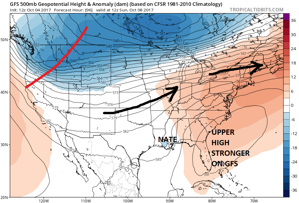
it should be noted that the GFS is not doing much with this regarding intensity while other models are more robust with developing Nate into a category 1 or 2 hurricane. The GFS model seems to show some issues regarding the trough that is sitting across Florida and the Bahamas and that it somehow gets involved here with Nate. Some of the more reliable intensity models however are pushing Nate at least to a high end tropical storm or a low end hurricane. What it does when it gets into the Northwest Caribbean with the very warm water temperatures and the very low wind shear will set the table as far as strength goes.
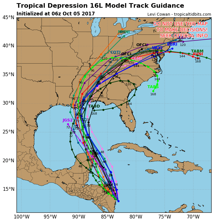
The overnight hurricane tracking models seem to be tightly clustered over Southeast Louisiana and New Orleans. When the models tightly cluster like this it lends a higher degree of confidence in the forecast. As far as we are concerned some of that rain may eventually make it our way Monday and Tuesday but how much remains to be seen. Tracks west of the Appalachians normally are not big rain producers for us unless there is some sort of potent upper air system to support a post tropical system moving through. There is some suggestion of this but I am not completely sold yet given the very dry nature of our weather pattern at the moment.
MANY THANKS TO TROPICAL TIDBITS FOR THE WONDERFUL USE OF THE MAPS
 GET JOE A CIGAR IF YOU LIKE

SHOP THE JOESTRADAMUS STORE
Weather App

Don’t be without Meteorologist Joe Cioffi’s weather app. It is really a meteorologist app because you get my forecasts and my analysis and not some automated computer generated forecast based on the GFS model. This is why your app forecast changes every 6 hours. It is model driven with no human input at all. It gives you an icon, a temperature and no insight whatsoever.
It is a complete weather app to suit your forecast needs. All the weather information you need is right on your phone. Android or I-phone, use it to keep track of all the latest weather information and forecasts. This weather app is also free of advertising so you don’t have to worry about security issues with your device. An accurate forecast and no worries that your device is being compromised.
Use it in conjunction with my website and my facebook and twitter and you have complete weather coverage of all the latest weather and the long range outlook. The website has been redone and upgraded. Its easy to use and everything is archived so you can see how well Joe does or doesn’t do when it comes to forecasts and outlooks.
Just click on the google play button or the apple store button on the sidebar for my app which is on My Weather Concierge. Download the app for free. Subscribe to my forecasts on an ad free environment for just 99 cents a month.
Get my forecasts in the palm of your hand for less than the cost of a cup of Joe!