Tropical Storm Maria Likely To Form Later Today Watches Posted
Tropical Storm Maria Likely To Form Later Today
Tropical Storm Watches Posted
A Tropical Storm Watch is in effect for…
* St. Lucia
* Martinique
* Guadeloupe
* Dominica
SATELLITE LOOP

Disturbed weather just to the east of the Lesser Antillies is rapidly organizing this afternoon as a tight circulation center appears to be developing. It is very likely that this system will be upgraded to Tropical Storm Maria later today. Watches are up for some the islands.
…TROPICAL STORM WATCHES ISSUED FOR A PORTION OF THE LESSER
ANTILLES…
SUMMARY OF 1100 AM AST…1500 UTC…INFORMATION
———————————————–
LOCATION…12.2N 50.5W
ABOUT 755 MI…1220 KM ESE OF THE LESSER ANTILLES
MAXIMUM SUSTAINED WINDS…35 MPH…55 KM/H
PRESENT MOVEMENT…W OR 280 DEGREES AT 22 MPH…35 KM/H
MINIMUM CENTRAL PRESSURE…1008 MB…29.77 INCHES
WATCHES AND WARNINGS
——————–
CHANGES WITH THIS ADVISORY:
The government of St. Lucia has issued a Tropical Storm Watch for
St. Lucia.
The government of France has issued a Tropical Storm Watch for
Martinique and Guadeloupe.
The government of Barbados has issued a Tropical Storm Watch for
Dominica.
SUMMARY OF WATCHES AND WARNINGS IN EFFECT:
A Tropical Storm Watch is in effect for…
* St. Lucia
* Martinique
* Guadeloupe
* Dominica
A Tropical Storm Watch means that tropical storm conditions are
possible within the watch area, generally within 48 hours.
Interests elsewhere in the Lesser Antilles should monitor the
progress of this system. Additional Tropical Storm or Hurricane
Watches will likely be issued later today.
For storm information specific to your area, please monitor products
issued by your national meteorological service.
DISCUSSION AND 48-HOUR OUTLOOK
——————————
At 1100 AM AST (1500 UTC), the disturbance was centered near
latitude 12.2 North, longitude 50.5 West. The system is moving
toward the west near 22 mph (35 km/h). A slower west-northwest
motion is expected during the next couple of days. On the forecast
track, the system is expected to approach the Leeward Islands on
Monday.
Maximum sustained winds are near 35 mph (55 km/h) with higher gusts.
Strengthening is expected during the next 48 hours. The
disturbance is forecast to become a tropical storm later today and
could be near hurricane strength when it approaches the Leeward
Islands.
Satellite images indicate that the disturbance has become better
organized, and it is expected to become a tropical cyclone later
today or tonight.
* Formation chance through 48 hours…high…near 100 percent
* Formation chance through 5 days…high…near 100 percent
The estimated minimum central pressure is 1008 mb (29.77 inches).
HAZARDS AFFECTING LAND
———————-
WIND: Hurricane conditions are possible within portions of Leeward
Islands by Monday night or Tuesday, with tropical storm conditions
possible on Monday.
RAINFALL: The system is expected to produce total rain
accumulations of 5 to 10 inches with isolated maximum amounts of 15
inches across portions of the central and southern Leeward Islands
through Tuesday night. These rains could cause life-threatening
flash floods and mudslides.
SURF: Swells generated by the system are expected to begin
affecting the Lesser Antilles by Sunday night. These swells are
likely to cause life-threatening surf and rip current conditions.
Please consult products from your local weather office.
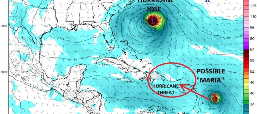
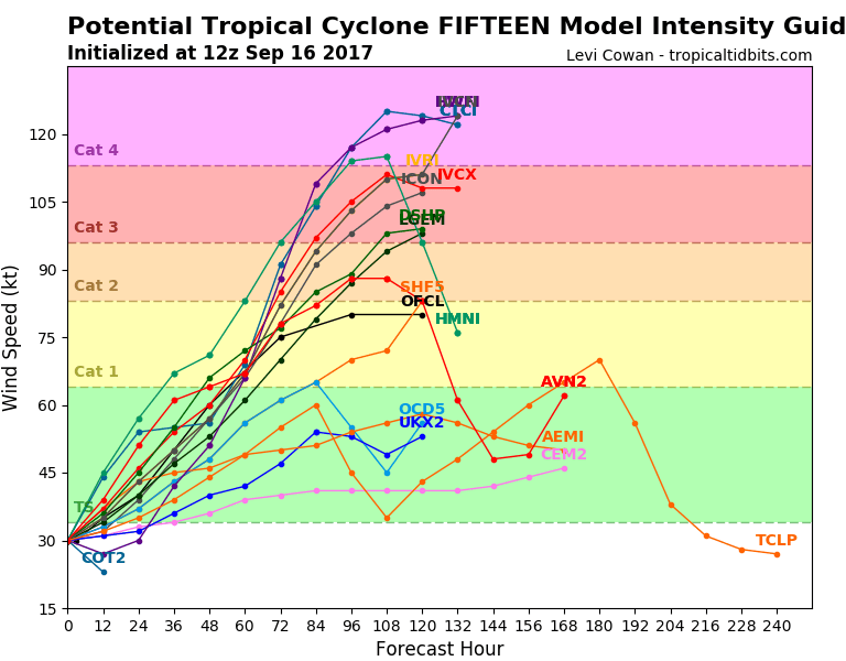
Weather models are very aggressive with developing this into a hurricane once it moves into the Northeast Caribbean and hurricane conditions are possible for the Northern Leeward Islands. There could also be risk to Puerto Rico and the Dominican Republic in the longer term later next week.
GFS MODEL SUNDAY 2PM
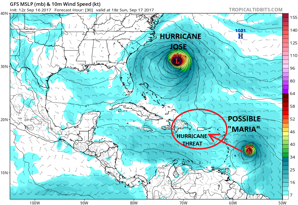
The GFS model suggests this system will strengthen rapidly through at least tomorrow and possibly beyond tomorrow. Conditions are quite favorable for strengthening to a hurricane in a hurry so this will be watched very closely. You can expect Maria to burst on the scene later today. Longer term a west northwest track is favored possibly toward the Bahamas late next week. Intensity models are also very aggressive and more models than not, make Maria a major hurricane. This one will need to be watched.
LOCAL RADAR MIAMI FLORIDA
 GET JOE A CIGAR IF YOU LIKE

FiOS1 News Weather Forecast For Long Island
FiOS1 News Weather Forecast For New Jersey
FiOS1 News Weather Forecast For Hudson Valley