
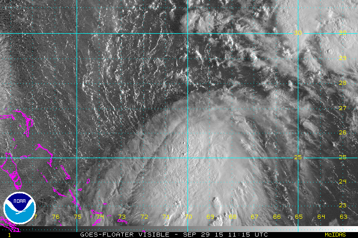
Satellite pictures during the night show little chance in strength of Tropical Storm Joaquin. The storm has been on a slow westward drift and you can see all the action going on around it. First off on the mainland the approaching cold front and the moisture from the Eastern Gulf and Southeastern states continues to lift nortward ahead of it. This is the tropical feed that should enhance our rain later tonight and on Wednesday. Meanwhile there is an upper low northeast of Tropical Storm Joaquin which should eventually leave the tropical storm in a more relaxed shearing environment. You can plainly see the puzzle that is developing and the scenario is quite complex. It is hard to pick out the center of circulation given this is the first visible satellite picture of the morning so we will wait a few hours when there is enough for a loop. It appears to me most of the convection is east and south of the center due to northerly shear around the upper low to the northeast.
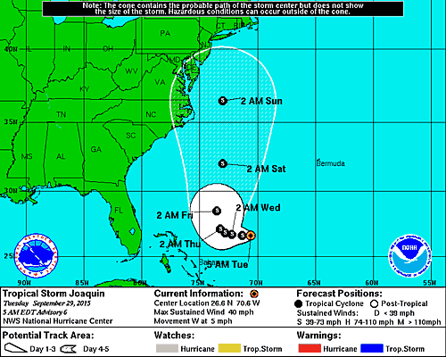
..TROPICAL STORM JOAQUIN MOVING WESTWARD WITH NO CHANGE IN STRENGTH...


SUMMARY OF 500 AM EDT...0900 UTC...INFORMATION
----------------------------------------------
LOCATION...26.6N 70.6W
ABOUT 385 MI...620 KM NE OF THE CENTRAL BAHAMAS
MAXIMUM SUSTAINED WINDS...40 MPH...65 KM/H
PRESENT MOVEMENT...W OR 270 DEGREES AT 5 MPH...7 KM/H
MINIMUM CENTRAL PRESSURE...1002 MB...29.59 INCHES


WATCHES AND WARNINGS
--------------------
There are no coastal watches or warnings in effect.


There are all sorts of developments regarding some overnight models and what they do with this storm. Here is the bottom line…whether Joaquin moves up the coast or not, we will be impacted by a strong onshore flow, gales, coastal flooding, and heavy rains much like you would any noreaster. If Joaquin comes into play it could complicate matters further depending on what exactly we are dealing with.
The National Hurricane Center forecast is simply an update of the previous one with a little slower movement. Please be advised that you are going to be hearing all sorts of things and seeing all sorts of maps being displayed all over creation. I am trying to keep this as straight forward as I can as the forecast journey continues.
Be sure to download my weather app and subscribe to my forecasts. The app is free and the subscription is just 99 cents a month. The app is free of advertisement and there are no tracking or security issues.