If Henri is a tropical storm it barely is one as the circulation center sits at the edge of the main convection to the east. You can see that it is well east of Bermuda by a couple of hundred miles and currently not moving much. However t looks like some convective bursting is going on and it will be under a low shearing environment today into Friday so it has time and space to strengthen some.

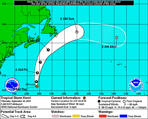
...TROPICAL STORM HENRI MOVING SLOWLY NORTHWARD


SUMMARY OF 500 AM AST...0900 UTC...INFORMATION
----------------------------------------------
LOCATION...31.4N 61.0W
ABOUT 230 MI...370 KM ESE OF BERMUDA
MAXIMUM SUSTAINED WINDS...40 MPH...65 KM/H
PRESENT MOVEMENT...N OR 350 DEGREES AT 3 MPH...6 KM/H
MINIMUM CENTRAL PRESSURE...1008 MB...29.77 INCHES

With regards to the future of Tropical Storm Henri there is no change at all in the forecast logic. A deep trough will be in the east and that will take Tropical Storm Henri to the northeast and east and it eventually gets absorbed by the large ocean storm that sits in the North Atlantic.

Once this goes out the tropics on the Atlantic side look to be quiet as the shearing pattern across the Atlantic looks for lack of a better word ridiculous with strong winds everywhere. The only place where there might be some action is perhaps in the Western Gulf of Mexico where some models, specifically the European want to develop something that actually originates from the Tropical Pacific and moves northward across southern Mexico and into the Southwest Gulf of Mexico. This sort of thing happens every once in awhile so we will see whether it happens or not. Not all the models are showing this and at this point I would rate it as something of a long shot. Storms that form in the Southwest Gulf can have a tough time dealing with proximity to land issues among other things even though the water is super warm. Otherwise the rest of the Atlantic tropics looks to be as dead as you can get.