
Tropical Storm Formation Southeast Coast Possible Monday
Tropical Storm Formation Southeast Coast Possible Monday

While all the attention has been on Harvey as it continues to release unrelenting heavy rain in Texas, there is disturbed weather from the Eastern Gulf of Mexico, across Florida, and off the Southeast coast of the US. Part of this is from an old cold front that stalled out a few days ago and part of it is from Tropical Wave 92L. Virtually all the weather models develop low pressure over Florida that moves off the coast and gradually develops as it moves north northeastward straddling the Carolinas until it gets northeast of Hatteras.

As of now the weather remains very disorganized. The outflow from Harvey is having some impact with strong northerly winds aloft. However as the low moves away from Florida it will be outside the outflow from Harvey which should allow strengthening to occur beginning on Monday.

Weather models seem to agree on two things. First is that a tropical depression or tropical storm will develop as the low moves north northeastward up the coast from Florida to North Carolina. The strong high to the north will create a rather tight pressure gradient and there will be inrcreasing winds from Coastal Virginia southward to Georgia with rain along and just inland of the coast.
TROPICAL STORM FORMATION POSSIBLE SOUTHEAST US COAST EARLY NEXT WEEK CLICK TO ANIMATE
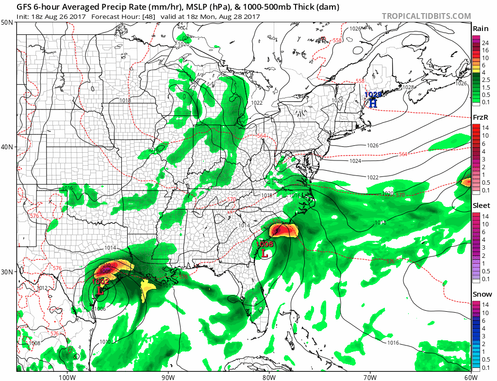
Weather models also agree that once the system reaches Northeast North Carolina it will be kicked out to the east northeast due to a flattening jet stream pattern. Just like a system in the winter time, high pressure to the north will suppress this southward. Unless the upper trough to the west is stronger and creates a more southerly flow along the Eastern Seaboard this should not be a big deal for us. Rain could reach Southern New Jersey at its furthest northern point before pulling away to the east Tuesday night.
TROPICAL STORM FORMATION POSSIBLE HURRICANE MODEL GUIDANCE
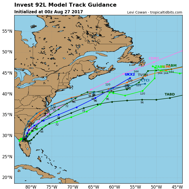
The latest hurricane model track guidance is in linewith the global models on this at least for now. We will of course monitor weather models overnight and on Sunday in case there are any important changes. For now Sunday looks like another day of sunshine and highs in the 70s. Monday we will see sunshine giving way to arriving clouds with the developing onshore flow. Tuesday we will see lots of clouds with rain just to the south as this system makes its closest approach. Eventually this could be come an Atlantic hurricane and head close to the Canadian Maritime Provinces later this week
MANY THANKS TO TROPICAL TIDBITS FOR THE WONDERFUL USE OF THE MAPS
Weather App

Don’t be without Meteorologist Joe Cioffi’s weather app. It is really a meteorologist app because you get my forecasts and my analysis and not some automated computer generated forecast based on the GFS model. This is why your app forecast changes every 6 hours. It is model driven with no human input at all. It gives you an icon, a temperature and no insight whatsoever.
It is a complete weather app to suit your forecast needs. All the weather information you need is right on your phone. Android or I-phone, use it to keep track of all the latest weather information and forecasts. This weather app is also free of advertising so you don’t have to worry about security issues with your device. An accurate forecast and no worries that your device is being compromised.
Use it in conjunction with my website and my facebook and twitter and you have complete weather coverage of all the latest weather and the long range outlook. The website has been redone and upgraded. Its easy to use and everything is archived so you can see how well Joe does or doesn’t do when it comes to forecasts and outlooks.
Just click on the google play button or the apple store button on the sidebar for my app which is on My Weather Concierge. Download the app for free. Subscribe to my forecasts on an ad free environment for just 99 cents a month.
Get my forecasts in the palm of your hand for less than the cost of a cup of Joe!