The track of Erika continues to be SOUTH of all the previous forecasts as the main center seems to be where the heaviest convection is. The shear environment continues to cause havoc with several centers coming and going. While the system is producing gales it is in an area northeast of the center. The pressure on the last recon fix was 1011mb which is pretty high for a tropical storm.
SUMMARY OF 200 PM AST…1800 UTC…INFORMATION
———————————————-
LOCATION…17.7N 70.2W
ABOUT 60 MI…95 KM SW OF SANTO DOMINGO DOMINICAN REPUBLIC
ABOUT 305 MI…490 KM SE OF GREAT INAGUA ISLAND
MAXIMUM SUSTAINED WINDS…50 MPH…85 KM/H
PRESENT MOVEMENT…W OR 280 DEGREES AT 18 MPH…30 KM/H
MINIMUM CENTRAL PRESSURE…1009 MB…29.80 INCHES
WATCHES AND WARNINGS
——————–
CHANGES WITH THIS ADVISORY:
The Tropical Storm Warning has been discontinued for Puerto Rico,
Vieques, and Culebra.
SUMMARY OF WATCHES AND WARNINGS IN EFFECT:
A Tropical Storm Warning is in effect for…
* Dominican Republic
* Haiti
* Southeastern Bahamas
* Turks and Caicos Islands
* Central Bahamas
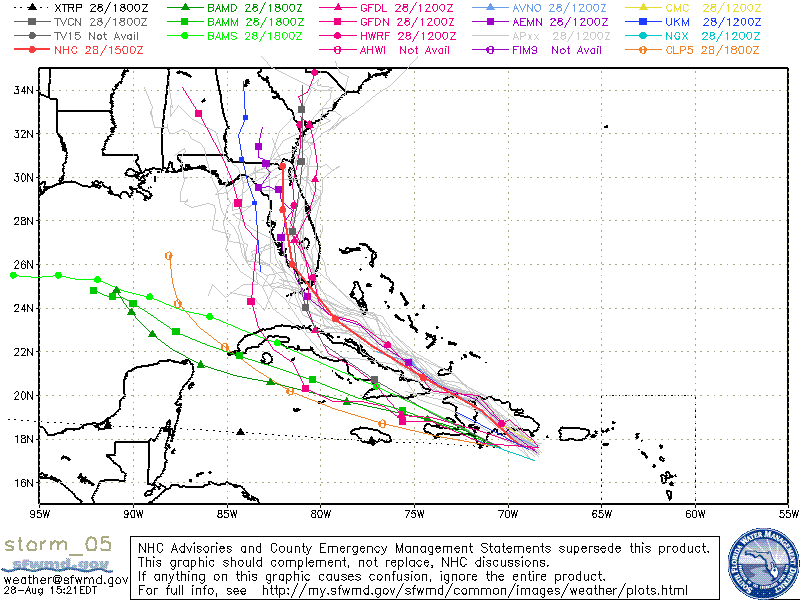
The main center is tracking south of Hispaniola and if the westward course continues Jamaica could be next in line. If the southern center is the main deal and it doesn’t reform north of the islands, then the threat to Florida lessens over time and the threat to the US SE Coast drops to almost zero. We aren’t ready to go that route yet and will wait for more information at 5pm. It should be noted that on the GFS you can’t even find it. The European takes it into the NE Gulf of Mexico as a weak system. The spaghetti plots have now all shifted into the Gulf of Mexico (gee what at surprise).