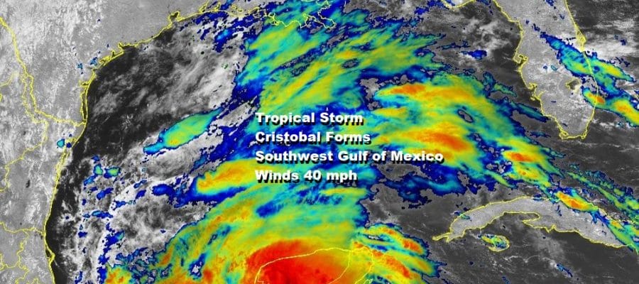
Tropical Storm Cristobal Forms Earliest 3rd Storm Of Hurricane Season
LOCATION…19.3N 92.7W
ABOUT 150 MI…245 KM WSW OF CAMPECHE MEXICO
ABOUT 135 MI…215 KM NE OF COATZACOALCOS MEXICO
MAXIMUM SUSTAINED WINDS…40 MPH…65 KM/H
PRESENT MOVEMENT…SW OR 230 DEGREES AT 3 MPH…6 KM/H
MINIMUM CENTRAL PRESSURE…1004 MB…29.65 INCHES
Hurricane Season 2020 is barely 2 days old and we have already seen the 3rd name storm of the season. This is the earliest we have ever seen the “C” storm eclipsing 2016 when Colin formed on June 5th. This morning the depression in the Southwest Gulf of Mexico got better organized and the latest NOAA aircraft reported two belts of 45 to 50 knot winds south and north of the center. That pius a pressure down to 1004 mb was enough for the National Hurricane Center to upgrade this to a tropical Storm.
SATELLITE

Cristobal is not moving very much today nor will it for the next day or two. Upper level winds are favorable for some strengthening but it will probably occur slowly until the depression starts a northward drift and heads out into the south central Gulf of Mexico late this week.

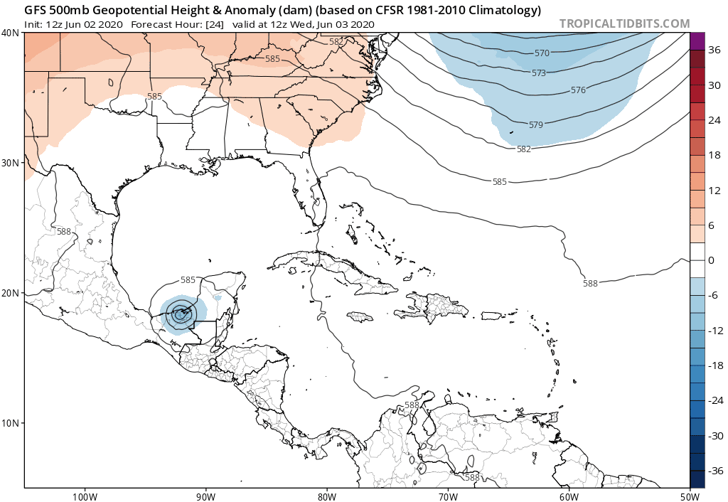
We see the National Hurricane Center’s forecast above which follows the model logic. Below is the upper air of the GFS. In the Gulf of Mexico Cristobal is sandwiched between 2 upper highs. One is to the northwest and the other to the east. This is going to eventually create a southerly flow to carry the storm northward. Yesterday we talked of the possibility of Cristobal moving inland only to have another tropical storm form inside the large moist upper air circulation that exists over Central America. This seems less likely as long as Cristobal remains over the open waters and doesn’t drift southwest and inland over Mexico.
Once we see whether Cristobal stays over the open waters then we can determine the extent of any threat to the Central Gulf Coast. We should know that in a day or so. Timing would look to be perhaps sometime Sunday for this system to head for the coast. Heavy rain looks to be the primary issue here. The broad nature of this system probably means it doesn’t strengthen to a hurricane before landfall however I would not discount that possibility completely. Upper air winds would suggest slow strengthening along the way and not a rapid deepening. However we have seen stranger things happen when it comes to tropical systems in the Gulf of Mexico.
BE SURE TO DOWNLOAD THE FREE METEOROLOGIST JOE CIOFFI WEATHER APP &
ANGRY BEN’S FREE WEATHER APP “THE ANGRY WEATHERMAN!
MANY THANKS TO TROPICAL TIDBITS FOR THE USE OF MAPS
Please note that with regards to any severe weather, tropical storms, or hurricanes, should a storm be threatening, please consult your local National Weather Service office or your local government officials about what action you should be taking to protect life and property.


