Tropical Storm Cindy Flash Floods Heavy Rains Continue
Tropical Storm Cindy Flash Floods Heavy Rains Continue
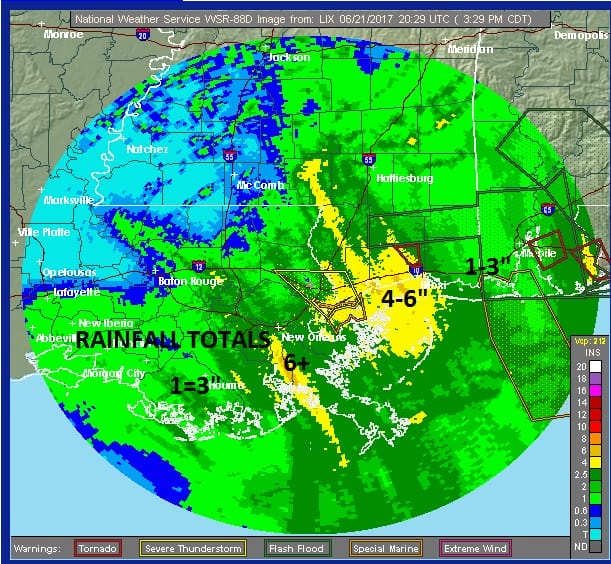
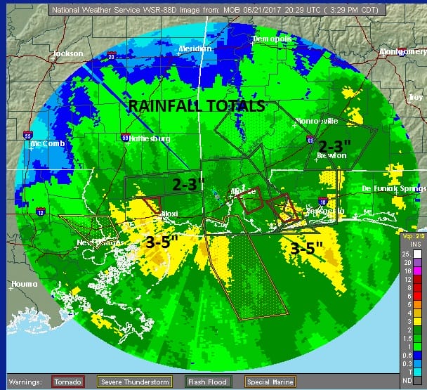
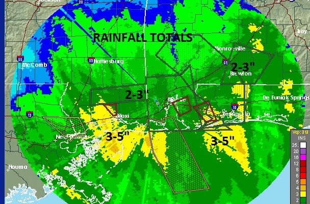
The maps above show radar estimates of rainfall so far and these are estimates. It is entirely possible that some local areas could have higher amounts. So far the heaviest rains have been from the Florida Panhandle west to Southeast Louisiana where some 6 inch plus areas are beginning to show up. Tropical Storm Cindy is building on its reputation for being a heavy rain and flash flood producer and the rains as shown on the real time radar loops below will continue overnight.
TROPICAL STORM CINDY SATELLITE LOOP

The satellite loop shows the circulation moving northward toward the coast right near the border of Texas and Louisiana. There has been some increase in convection this afternoon on the northwest side of the broad circulation. Not much change in strength is expected between now and landfall during the early morning hours on Thursday.
BULLETIN
Tropical Storm Cindy Advisory Number 9
NWS National Hurricane Center Miami FL AL032017
400 PM CDT Wed Jun 21 2017
…HEAVY RAINFALL FROM CINDY AFFECTING THE NORTHERN GULF COAST…
…THESE RAINS COULD PRODUCE LIFE-THREATENING FLASH FLOODING…
SUMMARY OF 400 PM CDT…2100 UTC…INFORMATION
———————————————-
LOCATION…28.2N 93.2W
ABOUT 135 MI…215 KM S OF LAKE CHARLES LOUISIANA
ABOUT 125 MI…200 KM SE OF GALVESTON TEXAS
MAXIMUM SUSTAINED WINDS…50 MPH…85 KM/H
PRESENT MOVEMENT…NW OR 315 DEGREES AT 9 MPH…15 KM/H
MINIMUM CENTRAL PRESSURE…994 MB…29.36 INCHES
WATCHES AND WARNINGS
——————–
CHANGES WITH THIS ADVISORY:
None.
SUMMARY OF WATCHES AND WARNINGS IN EFFECT:
A Tropical Storm Warning is in effect for…
* San Luis Pass Texas to the mouth of the Mississippi River
A Tropical Storm Warning means that tropical storm conditions are
expected somewhere within the warning area, in this case within the
next 12 to 24 hours.
Interests elsewhere along the U.S. Gulf Coast from the central Texas
coast to the western Florida Panhandle should monitor the progress
of this system.
For storm information specific to your area, including possible
inland watches and warnings, please monitor products issued by your
local National Weather Service forecast office.
DISCUSSION AND 48-HOUR OUTLOOK
——————————
At 400 PM CDT (2100 UTC), the center of Tropical Storm Cindy was
located near latitude 28.2 North, longitude 93.2 West. Cindy is
moving toward the northwest near 9 mph (15 km/h). A turn toward the
north-northwest is expected tonight and Thursday, with a turn toward
the northeast expected on Friday. On the forecast track, the center
of Cindy will move inland over southeastern Texas or southwestern
Louisiana late tonight or early Thursday, then move near or over
extreme eastern Texas, western and northern Louisiana, and
southeastern Arkansas Thursday and Thursday night.
Maximum sustained winds are near 50 mph (85 km/h) with higher gusts.
Little change in strength is expected before landfall, with
weakening expected thereafter.
Tropical-storm-force winds extend outward up to 115 miles (185 km)
from the center.
The estimated minimum central pressure based on observations from
oil rigs near the center is 994 mb (29.36 inches).
HAZARDS AFFECTING LAND
———————-
RAINFALL: Cindy is expected to produce total rain accumulations of
6 to 9 inches with isolated maximum amounts up to 15 inches over
southeastern Louisiana, southern Mississippi, southern Alabama, and
western portions of the Florida Panhandle through Thursday night.
This rainfall could cause life-threatening flash flooding in these
areas.
Rainfall amounts of 3 to 5 inches with isolated maximum amounts of
7 inches can be expected farther west across western Louisiana and
eastern Texas through Thursday night. Rainfall should spread
northeastward across Arkansas and into portions of the Tennessee
and Ohio Valleys through Friday, with total rain accumulations of
3 to 5 inches with locally higher amounts possible.


JOESTRADAMUS HURRICANE SEASON GUEST FORECAST
FiOS1 News Weather Forecast For Long Island
FiOS1 News Weather Forecast For New Jersey
FiOS1 News Weather Forecast For Hudson Valley
NATIONAL WEATHER SERVICE SNOW FORECASTS
LATEST JOESTRADAMUS ON THE LONG RANGE
Weather App

Don’t be without Meteorologist Joe Cioffi’s weather app. It is really a meteorologist app because you get my forecasts and my analysis and not some automated computer generated forecast based on the GFS model. This is why your app forecast changes every 6 hours. It is model driven with no human input at all. It gives you an icon, a temperature and no insight whatsoever.
It is a complete weather app to suit your forecast needs. All the weather information you need is right on your phone. Android or I-phone, use it to keep track of all the latest weather information and forecasts. This weather app is also free of advertising so you don’t have to worry about security issues with your device. An accurate forecast and no worries that your device is being compromised.
Use it in conjunction with my website and my facebook and twitter and you have complete weather coverage of all the latest weather and the long range outlook. The website has been redone and upgraded. Its easy to use and everything is archived so you can see how well Joe does or doesn’t do when it comes to forecasts and outlooks.
Just click on the google play button or the apple store button on the sidebar for my app which is on My Weather Concierge. Download the app for free. Subscribe to my forecasts on an ad free environment for just 99 cents a month.
Get my forecasts in the palm of your hand for less than the cost of a cup of Joe!
![]()
![]()