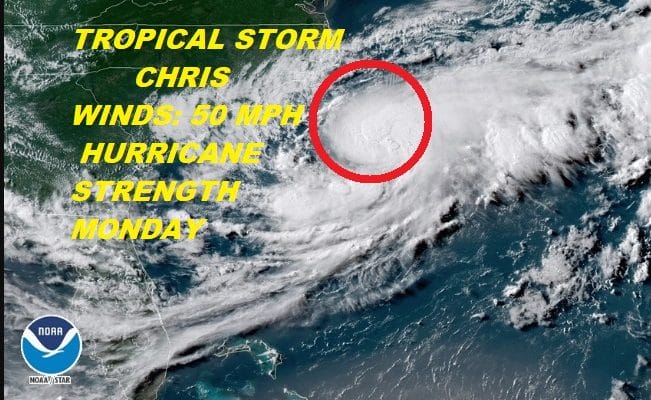
Tropical Storm Chris Better Organized Hurricane Strength Monday
Tropical Storm Chris Better Organized
Hurricane Strength Monday
Beryl Weakens To An Open Wave
Satellite loops this afternoon continue to show that Tropical Storm Chris is getting better organized as it sits off the North Carolina Coast. Steering currents have collapsed right on schedule and Chris will continue to meander over a very small area just offshore, but far enough offshore so that there are no impacts to the coastline other than the building surf. The core of Tropical Storm Chris remains well offshore and will remain offshore as it strengthens to a hurricane sometime on Monday.
WESTERN ATLANTIC TROPICAL SATELLITE

There are not changes in the outlook for Chris as it waits for a deeper trough in the upper flow to move across the Great Lakes and Northeast on Tuesday. This will open up a passage way for Chris to begin a move to the northeast and out to sea with the only impacts being to marine interests.
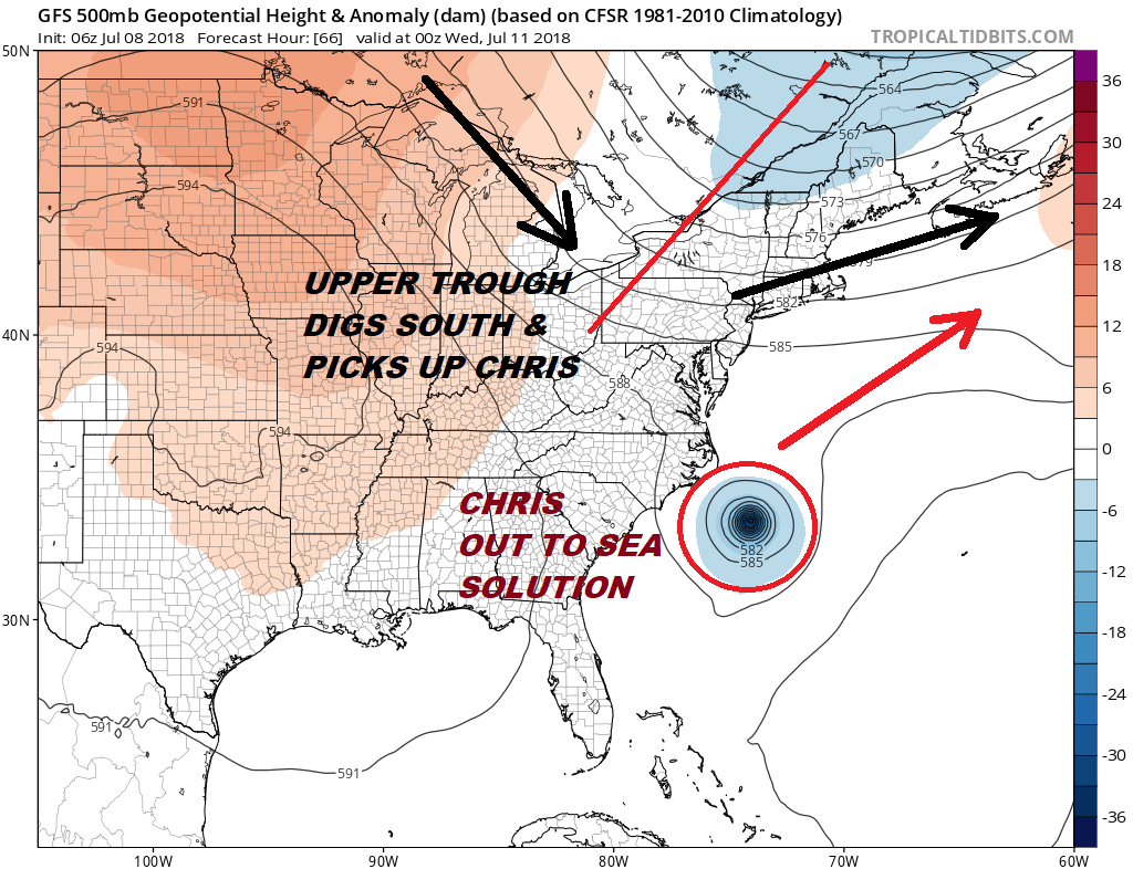
...CHRIS FORECAST TO STRENGTHEN AND REMAIN WELL OFFSHORE OF THE
U.S. COAST...


SUMMARY OF 500 PM EDT...2100 UTC...INFORMATION
----------------------------------------------
LOCATION...32.7N 74.6W
ABOUT 180 MI...290 KM SSE OF CAPE HATTERAS NORTH CAROLINA
MAXIMUM SUSTAINED WINDS...50 MPH...85 KM/H
PRESENT MOVEMENT...STATIONARY
MINIMUM CENTRAL PRESSURE...1008 MB...29.77 INCHES


WATCHES AND WARNINGS
--------------------
There are no coastal watches or warnings in effect.

Interests along the coast of North Carolina should monitor the
progress of this system.


DISCUSSION AND OUTLOOK
----------------------
At 500 PM EDT (2100 UTC), the center of Tropical Storm Chris was
located near latitude 32.7 North, longitude 74.6 West. Chris has
barely moved since yesterday, and no significant motion is expected
during the next 2 to 3 days.

Data from an Air Force reconnaissance plane indicate that the
maximum sustained winds have increased to near 50 mph (85 km/h) with
higher gusts. Chris is forecast to become a hurricane on Monday
and additional strengthening thereafter.

Tropical-storm-force winds extend outward up to 60 miles (95 km)
from the center.

The estimated minimum central pressure from a reconnaissance
aircraft is 1008 mb (29.77 inches).


HAZARDS AFFECTING LAND
----------------------
SURF:  Swells generated by Chris are expected to increase and affect
portions of the coasts of North Carolina and the mid-Atlantic states
into early next week.  These swells could cause life-threatening
surf and rip current conditions.  Please consult products from your
local weather office.
As far as Beryl is concerned it has degenerated into an open wave and it is no longer a tropical storm. There is a chance that Beryl could organize again as it moves towards the Bahamas later this week.
...REMNANTS OF BERYL RACING TOWARD THE LEEWARD ISLANDS...


SUMMARY OF 500 PM AST...2100 UTC...INFORMATION
----------------------------------------------
LOCATION...15.2N 60.3W
ABOUT 60 MI...95 KM NE OF MARTINIQUE
ABOUT 70 MI...110 KM ESE OF DOMINICA
MAXIMUM SUSTAINED WINDS...45 MPH...75 KM/H
PRESENT MOVEMENT...WNW OR 290 DEGREES AT 26 MPH...43 KM/H
MINIMUM CENTRAL PRESSURE...1007 MB...29.74 INCHES


WATCHES AND WARNINGS
--------------------
CHANGES WITH THIS ADVISORY:

The Government of Barbados has replaced the Tropical Storm Warning
for Dominica with a Tropical Storm Watch.

The other respective governments of the Caribbean area have
discontinued the Tropical Storm Warning for Guadeloupe, and have
discontinued the Tropical Storm Watch for Martinique, St. Martin,
St. Barthelemy, Saba, St. Maarten, and St. Eustatius.

SUMMARY OF WATCHES AND WARNINGS IN EFFECT:

A Tropical Storm Watch is in effect for...
* Dominica

A Tropical Storm Watch means that tropical storm conditions are
possible within the watch area, in this case, within the next 12
hours.

Interests elsewhere in the Leeward Islands, the Virgin Islands,
Puerto Rico, and the Dominican Republic should monitor the progress
of the remnants of Beryl.

For storm information specific to your area, please monitor
products issued by your national meteorological service.


DISCUSSION AND OUTLOOK
----------------------
At 500 PM AST (2100 UTC), the remnants of Beryl were located near
latitude 15.2 North, longitude 60.3 West. The remnants are moving
toward the west-northwest near 26 mph (42 km/h), and this general
motion is expected to continue into Monday. On the forecast track,
the remnants of Beryl will move across the Leeward Islands, and move
near or south of the Virgin Islands and Puerto Rico on Monday.

Maximum sustained winds are near 45 mph (75 km/h) with higher gusts.
Slight weakening is anticipated during the next 24 hours.

However, environmental conditions are expected to become somewhat
conducive for regeneration of a tropical cyclone in a few days
when the remnants of Beryl are forecast to move across the Bahamas
and the western Atlantic.
* Formation chance through 48 hours...low...near 0 percent
* Formation chance through 5 days...low...30 percent

Tropical-storm-force winds extend outward up to 45 miles (75 km),
mainly to the north and northeast of the center.

The estimated minimum central pressure is 1007 mb (29.74 inches).
FiOS1 News Weather Forecast For Long Island
FiOS1 News Weather Forecast For New Jersey
FiOS1 News Weather Forecast For Hudson Valley