
Tropical Storm Chris 40 Mph Forecast Hurricane Tuesday
Tropical Storm Chris 40 Mph Forecast Hurricane Tuesday
Overnight Tropical Depression 3 less than 200 miles off the North Carolina coast has strengthened to Tropical Storm Chris. On the wide satellite loop you can see Tropical Storm Chris in the upper left as convection increases overnight off the North Carolina coast. Well to the Southeast is Tropical Storm Beryl which continues to weaken as it heads toward the Leeward Islands.We will address Tropical Storm Beryl in a separate post.
WIDE ATLANTIC TROPICAL SATELLITE

On closer view on the satellite loop below much of the cloud cover with Tropical Storm Chris remains offshore and at the moment even though the Tropical Storm is close to the coast it is having no real impact other than some occasional gusty winds that aren’t really out of the ordinary and some high surf beach issues that could develop from Coastal Virginia southward to the South Carolina coast.
WESTERN ATLANTIC TROPICAL SATELLITE

...DEPRESSION BECOMES TROPICAL STORM CHRIS...
...FURTHER STRENGTHENING IS LIKELY WHILE IT MEANDERS OFF THE
CAROLINA COAST...


SUMMARY OF 500 AM EDT...0900 UTC...INFORMATION
----------------------------------------------
LOCATION...33.0N 75.5W
ABOUT 150 MI...245 KM S OF CAPE HATTERAS NORTH CAROLINA
MAXIMUM SUSTAINED WINDS...40 MPH...65 KM/H
PRESENT MOVEMENT...STATIONARY
MINIMUM CENTRAL PRESSURE...1010 MB...29.83 INCHES


WATCHES AND WARNINGS
--------------------
There are no coastal watches or warnings in effect.

Interests along the coast of North Carolina should monitor the
progress of this system.


DISCUSSION AND OUTLOOK
----------------------
At 500 AM EDT (0900 UTC), the center of Tropical Storm Chris was
located by an Air Force Reserve hurricane hunter aircraft near
latitude 33.0 North, longitude 75.5 West. Chris is forecast to
meander off the coast of the Carolinas for the next several days.
An acceleration toward the northeast is expected to begin on
Tuesday.

Data from an Air Force Reserve reconnaissance aircraft indicate that
the maximum sustained winds have increased to near 40 mph (65 km/h)
with higher gusts.  Additional strengthening is forecast, and Chris
is expected to become a hurricane by mid-week.

Tropical-storm-force winds extend outward up to 60 miles (95 km)
from the center.

The estimated minimum central pressure from reconnaissance data is
1010 mb (29.83 inches).


HAZARDS AFFECTING LAND
----------------------
SURF:  Swells generated by Chris are expected to increase and affect
portions of the coasts of North Carolina and the mid-Atlantic states
into early next week.  These swells could cause life-threatening
surf and rip current conditions.  Please consult products from your
local weather office.

WIND:  Winds to gale force not directly associated with Chris are
expected along the North Carolina coast and over Pamlico and
Albemarle Sounds during the next day or so.
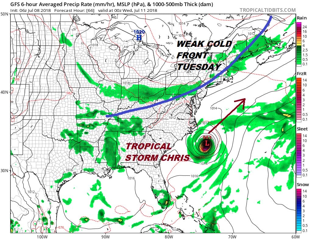
Weather models are all fairly consistent with the idea that Tropical Storm Chris is going to drift Southward or even a little bit to the southwest. Also strengthening is likely as conditions are favorable with the tropical storm sitting right over the gulf stream and low wind shear aloft. Tropical Storm Chris is likely to become a hurricane in the next two days. With the cold front to the north and the northern part of the jet stream dropping southward to the Middle Atlantic coast a northeast motion and a move out to sea is the most likely outcome.
UPPER AIR JET STREAM FORECAST TUESDAY JULY 10TH
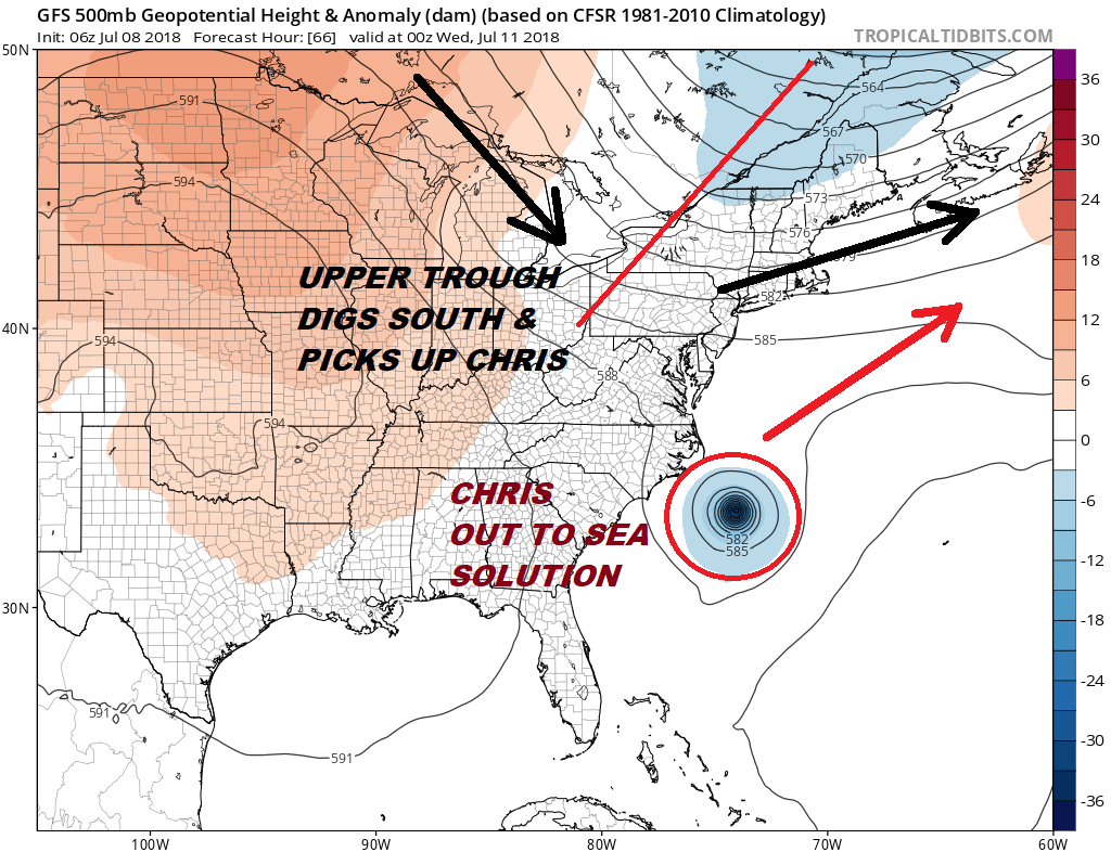
The GFS upper air jet stream shows the flow across the Northeast down to the Carolinas becomes westerly as the next trough in the flow comes along. This is the cold front that passes through our area Tuesday and it also is going to be strong enough and far enough south to give Tropical Storm Chris a swift kick to the northeast. At this stage Chris is likely to be a hurricane. Despite its close proximity to the Carolinas no land impacts are forecast and no watches or warnings are up at this time. The track to the northeast suggests impacts only for offshore marine interests though beaches could see some rough surf for a few days.
As far as local weather is concerned our beautiful weekend continues and here is the latest post.
Here is the latest on Tropical Storm Beryl as it nears the Leeward Islands.
FiOS1 News Weather Forecast For Long Island
FiOS1 News Weather Forecast For New Jersey
FiOS1 News Weather Forecast For Hudson Valley