Tropical Storm Barry Heading for Louisiana Coast Heavy Rain Threat Continues
Tropical Storm Barry continues to remain just that, a tropical storm with an elongated east west structure. While conditions remain favorable for strengthening time is beginning to work against this as the west northwest drift brings Barry closer to the coast. Gulf water temperatures are in the mid 80s and certainly supportive for strengthening as are favorable outflow conditions aloft. However we are talking about another 24 hours or so before landfall takes place somewhere in Southwest Louisiana. Top winds are 50 mph. The main issue here is going to be heavy rains that could last for several days or longer once the storm is inland due to weak upper air steering conditions.
SATELLITE

REGIONAL RADAR

On the regional and local radars this morning there isn’t much going on rain wise other than some bands of rain coming into rain soaked Southeast Louisiana but not much happening further west toward Lake Charles. That east west structure is keeping most of the heavy rain offshore for the time being.
LOCAL RADAR LAKE CHARLES

LOCAL RADAR NEW ORLEANS


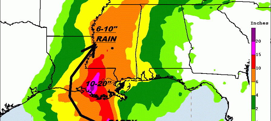
With landfall coming over the weekend and the very slow steering currents aloft we are going to see soe rather extreme rainfall amounts of 10 to 20 inches in some places and as we mentioned some areas in Southeast Louisiana have already gotten several to many inches already from the wet pattern across the Gulf States all week long.

The upper air pattern does not favor any of Barry’s moisture heading our way as the upper air jet stream pattern is not conducive to a flow from the southwest nor is there anything upstream in the overall pattern to bring the rain to the northeast. Barry will likely just rain itself out over the lower Mississippi Valley over the weekend and early next week.

Tropical Storm Barry Intermediate Advisory Number 8A
NWS National Hurricane Center Miami FL AL022019
700 AM CDT Fri Jul 12 2019
…BARRY MOVING SLOWLY WEST-NORTHWESTWARD TO THE SOUTH OF THE
COAST OF SOUTHEASTERN LOUISIANA…
…DANGEROUS STORM SURGE, HEAVY RAINS, AND WIND CONDITIONS
EXPECTED ACROSS THE NORTH-CENTRAL GULF COAST…
SUMMARY OF 700 AM CDT…1200 UTC…INFORMATION
———————————————-
LOCATION…28.2N 90.3W
ABOUT 95 MI…155 KM SW OF THE MOUTH OF THE MISSISSIPPI RIVER
ABOUT 120 MI…195 KM SSE OF MORGAN CITY LOUISIANA
MAXIMUM SUSTAINED WINDS…50 MPH…85 KM/H
PRESENT MOVEMENT…WNW OR 295 DEGREES AT 5 MPH…7 KM/H
MINIMUM CENTRAL PRESSURE…998 MB…29.47 INCHES
WATCHES AND WARNINGS
——————–
CHANGES WITH THIS ADVISORY…
None.
SUMMARY OF WATCHES AND WARNINGS IN EFFECT…
A Hurricane Warning is in effect for…
* Intracoastal City to Grand Isle
A Tropical Storm Warning is in effect for…
* Mouth of the Pearl River to Grand Isle
* Lake Pontchartrain and Lake Maurepas including metropolitan New
Orleans
* Intracoastal City to Cameron
A Storm Surge Warning is in effect for…
* Intracoastal City to Shell Beach
A Storm Surge Watch is in effect for…
* Shell Beach to the Mississippi/Alabama border
* Lake Pontchartrain
A Hurricane Watch is in effect for…
* Mouth of the Mississippi River to Grand Isle
* Intracoastal City to Cameron
A Tropical Storm Watch is in effect for…
* East of the Mouth of the Pearl River to the Mississippi/Alabama
border
MANY THANKS TO TROPICAL TIDBITS FOR THE USE OF MAPS
Please note that with regards to any tropical storms or hurricanes, should a storm be threatening, please consult your local National Weather Service office or your local government officials about what action you should be taking to protect life and property.